 Sometimes I’m busy, and sometimes I let things slip, but I usually come back to them with terrier-like tenacity.
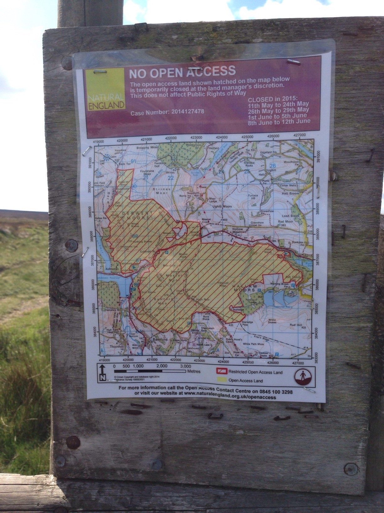
Using the hopeless GOV.UK site I found it impossible to understand how I could discover whether open access land, such as that depicted on this sign in the Peak District, would be closed or open a few weeks ahead – to plan my walks and holidays properly.
I ‘phoned the NE Open Access Contact Centre on the number given at the bottom of the sign illustrated here and spoke to a couple of helpful staff who couldn’t tell me whether the land in question would be closed for grouse shooting at any time during the grouse shooting season. Nor could they tell me whether or not it was possible that it might be closed, although they sort of suggested that maybe it could be and I should keep checking the website right up until the few days before I wanted to set foot on this open access land.
In response to my blog on the subject of a week ago, two NE staff posted comments. Neither answered the question about possible closures during the grouse shooting season though maybe I am supposed to infer that the land might be closed for safety reasons if people are killing wildlife in this part of the National Park on any particular day. One of them emailed me and copied in someone from the Peak District National Park who might be able to help me. They haven’t helped me yet – they haven’t been in touch yet.
So it seems that the way that a member of the public finds out about access to open access land in a National Park is to see a sign, then phone Natural England (twice), then write a blog, then read the comments from NE staff (which don’t answer the specific questions) then hope that someone else in the PDNP might get in touch, then write another blog and then email the PDNP directly to ask the same questions over again – and after you have done all that, you still haven’t got an answer.
I suspect that as a taxpayer and member of the public I am not the type of stakeholder that NE is now set up to deal with.
Is NE fit for purpose?
And I’m still not sure whether all or some of the land in question on that noticeboard is NT land or not. Perhaps they would like to tell me how I open a dialogue with them over my access, as a NT member, to their land in a National Park, which is used for grouse shooting.
[registration_form]
This was only 3-4 clicks away on the public website – accessible even to non-members
http://www.nationaltrust.org.uk/article-1356401398109/
Is this National Trust land then Mr Cobb? I thought in MA’s previous blog he had made it clear that it actually wasn’t.
“Perhaps they would like to tell me how I open a dialogue with them”
That, Mark, is of course the whole point – George Osborne would be proud of you – degrade then destroy – cut and cut and cut until the service provided is virtually non-existent then propose abolition or, more likely, amalgamation, and that’s dealt with the pesky wildlife getting in the way of house building, fracking, wind farms and whatever else is ‘economic development’.
It might just explain, too, why so many people didn’t buy the ‘access will be preserved’ story around the forest sales fiasco – there are enough people out there who realise what is going on to value that miniscule 2% of England’s land surface where public access really does come first and closures are managed to minimise, not as in this case, maximise, the uncertainty of visiting the countryside. There is access and access and the access to the national forest estate is of a very different character to almost any other major owner.
And surely that other great owner of land on behalf of the public, the National Trust, might like to tell us all whether or not this actually is all or part NT land ? And if so how it sees the closure regime and exactly who is responsible for making the closure ?
Ha ha!That just about covers the Tory anti-wildlife policy!
Your question. “Is NE fit for purpose?” NO. Not for a long time!
This is a truly appalling state of affairs, up here in the Dales we have had to put up with this since the inception of “Open Access” on some estates notably the notorious. The “information” maps at access points here only include single land holdings so if estate X are using their 28 days to keep us off in May and early June as usual that map ONLY contains information about that estate. Here if estates use all of their 28 days in the breeding season then they are NOT shut on shoot days but they use “Shoot security” to discourage you from “getting in the way”. Although of course you can walk through the middle of a drive, they’ll not shoot you!
Why not ask the man in charge…. is it David Cameron or something like that?
If you want to see what Land is National Trust owned, then use this web-site
http://www.ntlandmap.org.uk/
It seems to be that NT own a very small parcel of land (5 ha?) at Whinstone Lee Tor, but the main block of NT land is all to the west & north-west. [Derwent estate/Hope Woodlands]
Or look at the NBN Gateway, as the NT sites are listed & mapped there too (as are RSPB Reserves). https://data.nbn.org.uk/
Click on Browse Sites.