John Page was born in the West Riding, a proud Yorkshireman and was taught to play cricket left-handed “’cos it flummoxes t’ bowler, and buggers up t’ field”. He went to university in London and Leeds, and enjoyed (most of the time) attempting to teach young people that there’s a big wide world beyond the Colne and Worth Valleys. He also taught future captains of industry and government at the United World College of SE Asia in Singapore for four years. Except Antarctica, John has travelled and climbed extensively on all the world’s continents independently, with friends and with Hil, his wife of 44 years. Still very active in his 70s, retirement from paid employment was the best career move that he ever made.
Motto: “How can there be peace in the world if we don’t understand each other; and how can we understand each other if we don’t know one another?”.
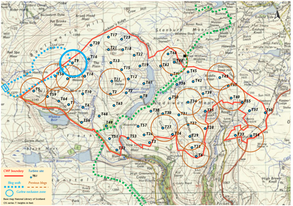
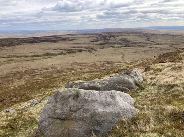
Turbine 9: Peacock Hill SD 93765 35063 ///chainsaw.electric.overcomes
It’s the weekend of the London Marathon. 26 miles and umpteen yards around the streets of London. Tens of thousands running. I did it once; when I could run, but urban running ain’t for me any more. Never mind 26 miles in around 3 hours. It’ll take me that time now to walk half a dozen miles over the pathless moors above Widdop. If the Calderdale Wind Farm is ever built there’ll be 26 miles of “floating roadways” linking the turbines together. Imagine it. I kept thinking about those floating roads as I sank into the peat bogs on my walk; desecration of this ethereal landscape .
Before I’d left home I’d watched a bit of Cecil Hepworth’s 1920 film: Helen of Four Gates. The scenery; the buildings. Take away the Saturday traffic and Widdop’s not really changed much in over 100 years . Should it in the future? I hope not but I’m nobbut a local lad. Well, a 72-year-old man from Slack.
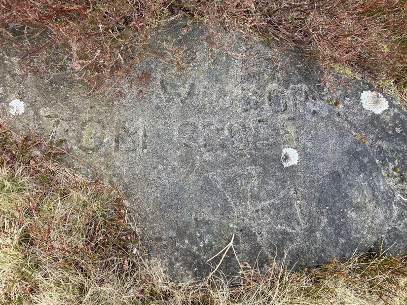
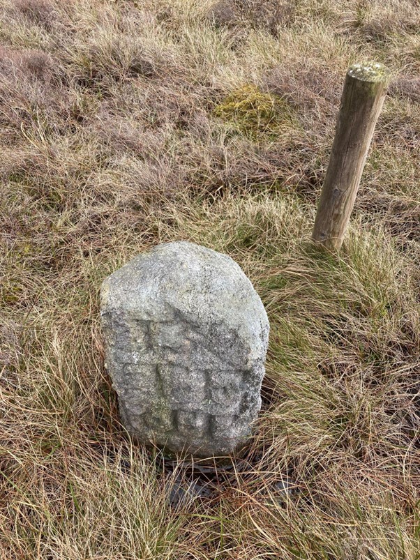
I’d left my car in a little pull-in off the road, just over the crest on the Thursden side, then walked on the road a few hundred yards to where a vague path leaves the Widdop Road at the Rigging Stones. There’s a couple of early boundary stones which my old OS map shows as marking the straight line of the “Euro Const & Co Const Bdy” . Now that we’re outwith the EU will that change on newer maps? Odd though, you’d expect the boundary to run along the watershed about half a mile to the north-west; geographical, but not socio-political logic. Still, after a few minutes at my slow pace uphill there’s the first of today’s “Interesting Old Stones”. “Widdop Tom Cross” is etched into rock, slowly being covered by a creeping moss. I’ve been up here dozens of times but I still have no idea who Tom was. I imagine him lost on the moor somewhere. Perhaps a farmer from one of the now long-gone farms across the valley; perhaps caught in a snowstorm while staggering home from a night with the boys in the Travellers’ Rest pub. That’s also long gone now, though its footings still are there, back down the road above the reservoir. Fanciful; but these moors, on a fine day, at a pedestrian pace, let the mind wander. I do a lot of pondering .
These moors have provided me with solace for over half a century now. While I grow older they remain ageless. They’ve always been there for me after a hard day at the chalk face or when a domestic issue needed to be thought through! “Just off for a run on t’moor. Clear me ‘ed . Back in a bit.” They’ve kept me sane….. I think; before “ mindfulness’ ‘ was thought important. Hopefully, when I’m gone they’ll still be here, intact, for others to appreciate and they’ll not be covered with floating roads and industrial infrastructure.
And after I’d left “Tom “ and struck out across the pathless, treeless waterlogged ground I could see the Dovestones in the distance. A longer line of “stones” among a landscape of small rock outcrops; almost a scar, an edge. And “edge” is really an appropriate name for today’s walk . This is a walk along the edge of the proposed industrial estate; along the edge of West Yorkshire. So by the time the “ constituency boundary” cuts through the northern end of the Dovestones I’d passed several boundary stones and the sites of a couple of possible turbines. Nominally I’m heading for T9, as the focus of this written piece, but really it could have been any of them, excepting those which Nick and Chris have already superbly written about.
I love the names on the map. They feed the imagination. I’ve passed Tom Groove Head (same Tom?), Crown Point Flat and Hey Slack…..and five miles distant my house is in Slack Top, and just past Slack Bottom is another Crown Point, synonymous with Ted Hughes! But the Dovestones?
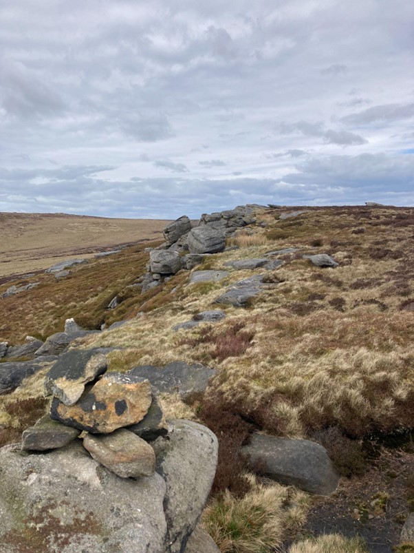
Much has been written of their spiritual significance; there’s evidence of more possible ancient etchings among the rocks but as I sit on the highest point I’m tempted to knock down the recently constructed small cairn that’s been put up there. I don’t but, really, there’s no need (at least in my mind) to build one here.
I used to run over these moors on warm summer evenings, and often I’d come here with my rock-climbing shoes. It’s not a fashionable bouldering place; not popular as the Bridestones are. But I used to love coming here. Short hard problems; excellent friction. Just me, the rock, and my own thoughts. Happy Days!
And the proposed T58 will dominate. And the early morning flickering shadows of T47 would be cast across the peace of the Dovestones as the turbine blades whirred round. I’m so sad for our next generation of young people if this monstrous scheme is given the go ahead.
I headed for the eastern side of Warcock Hill. I sunk deeply into carbon capturing gloop as I crossed the rightly named Foul Sike, my gardening trousers soaked up to my knees. Still, I was thankful it wasn’t raining, or snowing, or misty, or windy. Visibility was good and I could pick out a squat boundary stone in the distance. And this is the proposed site of T9 I reckoned. It’s right on the edge of the proposal and it would be “protected” by the moats of Foul Sike and Greave Clough.The “floating roads” will need quite substantial bridges to get them across the deep groughs. And then I thought of what that would involve , not only for the roads, but for the massive, deep concrete base as well that would be needed to support a 200 metre tall wind turbine. The logistics required to destroy a very fragile and unique ecosystem are complex. I replicated that vision 65 times. Inwardly I groaned.
I’m not against wind farms as such although I do have reservations about them. But there are far more suitable sites to place them. In this period of national energy transition traditional thermal power stations are being decommissioned, knocked down. We have vast areas of brownfield sites throughout the country since we’ve lost so much of our heavy and extractive industrial base. Why choose an area such as this, where from ground level at T9 there’s not another building in sight, nor even another person? Obviously it’s personal and corporate greed.
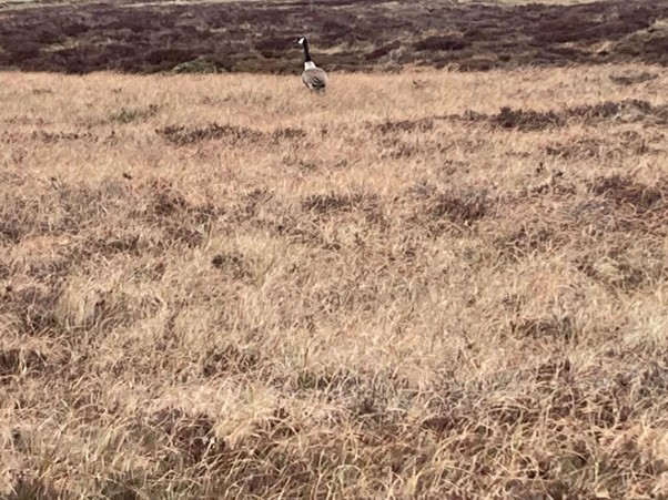
Anyway, despite a feeling of melancholy I heard the occasional lapwing, the peewit singing to me. It’s uplifting. I hadn’t seen a curlew so far despite “National Curlew Day” being the next day, but I began to sing to myself nevertheless and think of some old climbing and running friends I’d had; sadly, no longer with us. They’d penned: “The Fell Runners’ Song”:
The hare is in the heather, the birds up in the sky,
And the curlew sings his song to me,
As I go running by.
Heigh ho. Very happy days.
I pushed on, slowly. It’s at this point that I decided to leave the imagined boundary of the estate and head across the boggy head waters of Hole Syke Head. Not a misspelling on my part but a different way the original cartographers of the OS spelt “sike”, only half a mile from the Foul one.
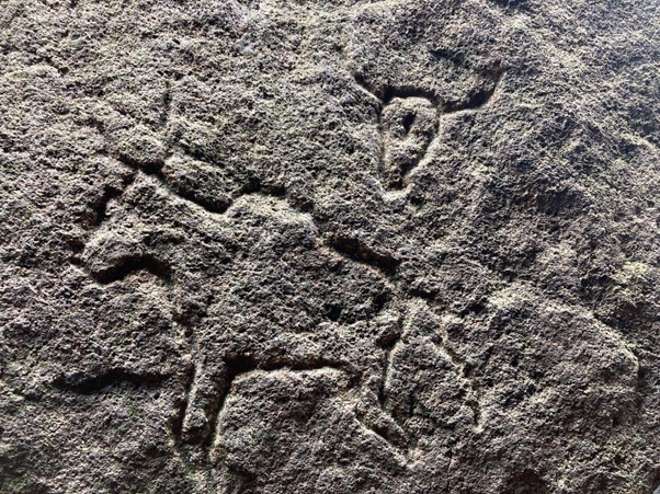
I wanted to go in search of more “ancient” etchings. During Lockdown I was told of the “neolithic” image of a bison, crudely cut into a hidden rock among the Saucer Stones. It was four years since I’d searched it out so it was a good opportunity to see if I could still find it. Fortunately, while my memory isn’t quite as good as it once was, the exact spot is still etched on my mind, a bit like the bison’s head. It’s well hidden, requiring a minor scramble and a drop into a hole between perched rocks. But it’s still there, although “neolithic” is stretching the imagination. A prank by some folk last century more like. Still, I like to think of ancient folk inspiring newer versions of age-old myths.
And it’s now significant that this “edge” of Saucer, Chair and Weather stones is the true watershed. Eastwards through the Sikes , Dikes, and Cloughs the catchment feeds into the mighty Calder and eventually it flows out to the North Sea. I took a leak and pondered on my water’s journey! And westwards; the Waters , Becks, and Brooks flow through Lancashire , joining the Brun and the inferior River Calder to then, finally , enter the Irish Sea. Sadly though, I’d no wee left for my neighbours. But still, this drainage divide is yet another significant geographical feature.
Lad Law (Boulsworth) is the only trig point on this walk. At this point I could wax lyrical about the history of triangulation pillars, Brigadier Martin Hotine and of their importance in the history of our landscape, but I won’t. Nonetheless, it’s a worthy spot to look out as far as Pendle Hill and the Dales and , on a very clear day, it’s acknowledged that you can see as far as the southern Lake District. It’s even possible to see out to the west coast, and in exceptional conditions, you can see Blackpool Tower; which raises the question: if those places can be seen from here, then surely lots of bright 200-metre-tall white wind turbines can also be seen from there as well, with a vast array of solar panels glistening in the bright Pennine sunshine. The Druids, who reputedly slaughtered folk on the nearby rocks would have presumably been thinking of more esoteric mysteries than the banality of industrial wind farms.
Still, as I stood next to the trig point I’d looked out over the nearby East Lancashire conurbation, and Burnley were beating Sheffield United at Bramall Lane! Lancashire v Yorkshire. A 90-minute game. Forgotten next season. And on Sunday the London Marathon was won in just over 2 hours and 3 minutes. But while the industrial mills that have shaped our northern urban geography have come and gone over the last 200 years or so, my traverse of the moors to this point has probably not changed much throughout that time, bar the occasional boundary marker and the many grouse feeding troughs which have now been added to the landscape. Walshaw Moor and this adjacent moorland is indeed a special place. I do feel privileged to have been able to get to know it better over the last 50 years or so. My hope is that this misguided proposal will eventually be turned down, and that future generations will still be able to enjoy the peace and solitude of this unique environment.
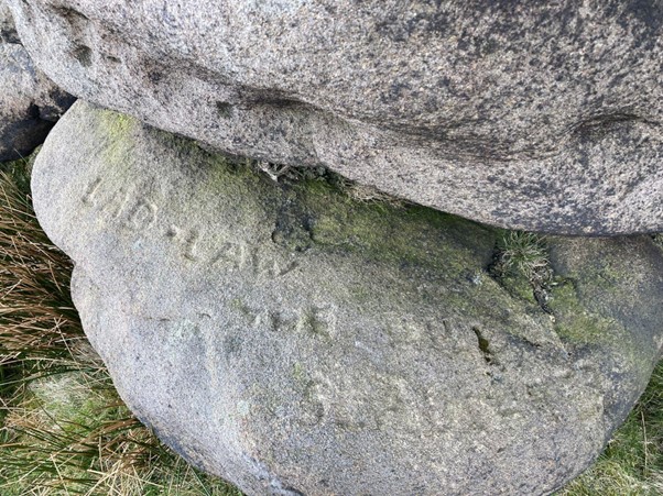
And wonderful. At the Slaughter Stone there are expansive views looking westwards as well. In the far distance there are already some small clusters of turbines but none contain more than ten. They are far away on the horizon. But, oh dear, the “empty” space in the foreground of my vision would be rammed full of 65 monsters if this proposal were to go ahead. Ts 5, 58 , 9, 20 and 17 would guard and dominate the north western edge of the Saudi Estate. The visible spaces in between would be filled in by those standing behind. A vision from Boulsworth Hill of a three-mile wall of 200-metre-tall swirling turbines. Aagh! The noise, at least, would terrify the Druids.
I set off down the path to the big motorable track that starts next to Hey Slacks Clough. The track’s about ¾ mile long. It’s easy but uninteresting and uninspiring walking, but it does its job of relaying me back to my car. But think of Walshaw Moor, congested, with another 26 miles of road like this dug into it.
And one final thought I’d had as I was driving back home. 65 seems to be a significant number. During Lockdown I had decided to challenge myself by visiting all the 65 trig points that are on the South Pennines 1:25,000 map, and then to write, with a bit of background research, about what I found out along the way. What a joy for an older, retired person to do. I collated all my written pieces and then put them together in book format, to subsequently bore my friends and family with. Still, the idea grew wings and it became a fund-raising “challenge” for Upper Valley folk, collecting money for Medecins Sans Frontieres along the way. Its success led to a Derelict Old Farms “challenge” and then two more “challenges”, searching out Interesting Old Stones, latterly raising money for the local Search and Rescue Team. Each challenge involved 65 trig points, 65 DOFs and 65 IOSs. Except for the paucity of trig points on proposed wind farm land, many of the other places in the challenges are located within its nine square miles.
So my hope is that they’ll all still be accessible if the wind farm is ever built; and that the next generation of Walshaw Moor-lovers don’t have to resort to visiting 65 wind turbines, via 26 miles of floating roads, as some sort of urban challenge. But if any money were to be raised it should certainly not go into a Bannister Legacy Fund. They’d have made enough millions out of this outrageous scheme already.
++++++++++++++++++++++++++++++++++++++++++++++++++++++
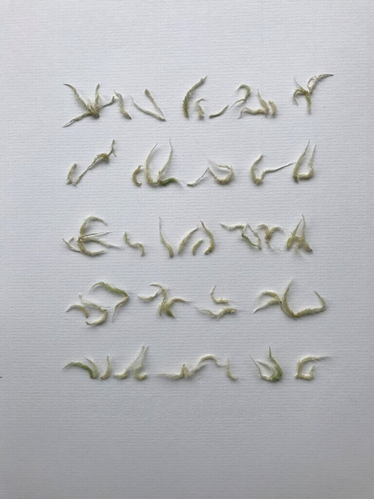
Sheila Tilmouth is a nature artist well-known to readers of this blog. She works out of a studio in Hebden Bridge. Asemic Writing is made from moss clipped on the walk to T5 Grey Stone Hill.
This is the 15th in a series of 65 guest blogs on each of the wind turbines which Richard Bannister plans to have erected on Walshaw Moor. Turbines 5, 6, 11, 27, 32, 34, 35, 40, 43, 44, 47, 54, 58 and 64 have already been described. To see all the blogs – click here.
[registration_form]
“I’m tempted to knock down the recently constructed small cairn that’s been put up there. I don’t but, really, there’s no need (at least in my mind) to build one here.”
You’re not the only one to think that. Someone I used to walk with was prosaically known as “the cairn-kicker”. And others didn’t disagree with his harmless hobby.
I fully understand the feelings of someone who draws great spiritual strength from such a location.
I’m not sure about these “suitable brownfield sites” – if you know them, name them.
All I know is that Scotland has completed a HUGE number of onshore windfarms – drive up the M74 and witness it for yourself.
In England, it’s too difficult or unpopular – (BTW, I’m English, residing in SW Scotland.)
The important thing is the functionality of the site; otherwise it’s a pointless development.
A regrettable, but probably inevitable, fact is that many of these sites have been developed by landed estates.
Up here, this is also true of the plantations which dominate many landscapes up here – incessantly being grown, cut down and replanted, all in the name of carbon reduction and all funded from the public purse.