After years of pressure from this blog and RaptorpersecutionUK Natural England has released a complicated Excel table of Hen Harriers’ last satellite fixes, in the middle of the night and with no media release or mention anywhere. This coincided with the presentation of … something … we don’t quite know what, and NE don’t want us to tell you even if we do know … at a scientific conference 4666 miles away from here.
When we eventually see the analysis and the results, which at best will be a couple of months away but could be much longer, I expect them to be dynamite which will blow the future of driven grouse shooting out of the water. But we’ll see.
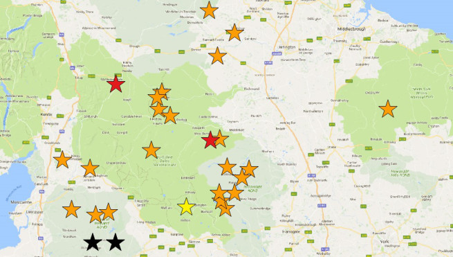
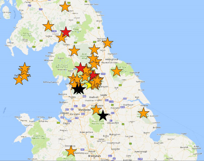
RPUK have done some through-the-night quick analysis of the locations which have now been revealed through their 6-figure grid references whereas they were only given as counties or general areas (eg Bowland) in the previous version of these data that NE were eventually shamed into releasing in September 2017. Read the RPUK blog for more info and follow them and this blog for more comment.
Do any of the tags show up on the Snilesworth Estate?
Miles – no last fixes anywhere in the North York Moors.
Yes there were Mark, sorry to disagree
Satellite 90691 F Bowland n/a 22-Jun-09 16-Feb-10 North York Moors SD612494 Missing Fate Unknown^ although the grid reference is wrong it should be SE not SD and the second three numbers are wrong I suspect they should be 944. I was told roughly where this was by somebody who knew. But in answer to the question it is still not on Snilesworth Estate.
Paul – that’s very helpful, thanks. One bird is listed as N York Moors but when you look up the grid reference it is in Bowland – perhaps the grid reference given is where the bird was hatched and not its last fix. If you are right about what the grid reference should be then the last fix was east of Snilesworth and due north of Helmsly. Thanks for that. I’ve found another error in the table too.
This means that RPUK have a star in Bowland that should be in N York Moors.
Mark, i think you mean due north of Helmsley.
Pretty sure there was another wildlife crime incident very close to the last known transmission within the last couple of years.
Prasad – I did, I’ve changed it, thanks.
ID58945 has the last transmission given as SD567780, which is near Hutton Roof, Cumbria but is given as Yorkshire Dales. It was apparently tagged in Cumbria so is this another mix up?
If these errors made it into the published data then it is one hell of a mess but maybe we can help to correct any errors before publication.
They may also be inadvertently publishing nest sites!
Prasad – good point. See latest blog.
There are two radio tagged birds that went missing in the NYM as well at SE634115 and SE865975.
Not too far away from a well known harrier death trap! if the North Yorkshire grid ref is correct .
Both complicity, the aiding and abetting of criminal activity within the driven grouse shooting industry (hobby), by Natural England and Scottish Natural Heritage should concern all UK nationals. They have lied, refused answers to freedom of information and are now shown to be governed by money/power brokers via political self interest. The perverse activity of a few, albeit rich and powerful, must end. Driven Grouse Shooting is an outdated hobby and underpinned by illegal activity against our environment and wildlife. People can and should mobilise against political complicity in this appalling misuse of our countryside. Angry me? You betcha…
I agree wholeheartedly with your comments. Then I saw this “It has already been a busy trip for the young royals with George being taken out yesterday for his first ever grouse shoot”. Blimey – he is only 5 years old. Some of us appear to be on a different planet!
“Release the data” and look what happens ! – lets hope the dominoes start falling. Time for action Michael Gove.
Natural England – partners in crime. What an epitaph.
I wonder if there is a department in the police force which deals with organised crime? This wouldkerp them busy.
I have always held a strong suspicion the hen harrier PHd being written by Stephen Murphy throughout a ten year period, was curtailed before being published because Stephen had diligently recorded locations where the bulk of satellite tagged hen harriers had ended up, on grouse moors.
Had Natural England allowed this data recorded on their behalf to be included in a peer reviewed published PHd we would have had the information much earlier. The only people non publication of Stephens PHd has benefited was the game shooting industry in my opinion. Could Natural England’s behaviour be classed as culpable negligence, covering up criminal offences?
Terry – you always go for the conspiracy theory don’t you? I’m not sure you are right.
Stephen is a very dedicated fieldworker and conservationist. I wonder whether he was given all the support that he needed to analys this dataset – I don’t think it is an easy job. NE don’t seem to have thrown their resources at ensuring these data were properly analysed until recently (maybe I’m wrong to think that) and after an awful lot of nagging by me and by others.
Mark I am not blaming Stephen in any way, in this instance the decision to withhold
and suppress data would not have been his.
Mark – I think you may have misinterpreted Terry’s original comment. Surely Terry was suggesting something very close to what you said – that NE did not give Stephen adequate encouragement and support to perform a complete analysis that would have allowed full publication in a serious journal. One reason why they might not have done so could be that they did not want too much attention directed at his findings.
It’s a conspiracy theory of sorts, but exactly the sort of thing that you and RPUK accuse NE of doing on a regular basis (a bit like suggesting that was why they chose to reveal the latest data at the time and place they did).
ID tag 94591 last known location was Bowland SD596621 which is 1km outside the last known transmission of Hope and 3km away from the centre of the overlap in last transmission of Hope and Sky.
https://ww2.rspb.org.uk/community/ourwork/skydancer/b/skydancer/archive/2014/10/08/sky-and-hope-a-plea-for-information.aspx
ID58870’s last known transmission was 2km outside the last known transmission of Sky and about 3.5km from centre of overlap of last known transmissions of Sky and Hope.
This along with comment about ID94591 is serious withholding of evidence of criminal activity. Isn’t that a crime? It is in the US.
I have only looked at 2 in Bowland and both ****ing suspicious!
Just noticed that the two birds that ‘disappeared’ in 2010 at Sky and Hope’s Bermuda triangle also stopped transmitting within 3 days of each other, the same as Sky and Hope!!
ID73591 LKL is given as Bowland SE090625 but that gridref is in North Yorkshire between Nidderdale and Wharfedale. It was apparently tagged in Bowland.
Sorry, that gridref is N. Yorks but NOT between Nidderdale and Wharfedale.
Natalie is obviously the wrong grid ref as it is exactly the same as Joanne with LKT as Cumbria (Natalie’s LKT is listed as Peak District).
What is going on?
73589 LKT was, if the gridref is correct, in North Yorkshire not ‘North Pennines, Cumbria’.
Prasad – you’re doing a great job in checking these! Thanks.
Amazing work Prasad. Thank you.
Thank you Mark for all your work as well.
Thanks as well to RPUK.
73588 LKT is according to the gridref in Nidderdale not Bowland.
58946** LKT is according to the gridref in Lowther not Langholm
74843 LKT is according to the gridref in Wensleydale not Niderdale (but not that far off)
Apologies for cross psoting to RPUK
All this shows that the incomplete data we were sent the first time, with name of location only, was totally inaccurate
Survival rate of young harriers is well known to be extremely poor with only around 36% of harriers making it through its first year. Also perhaps the human interference of satellite tagging may be reducing this even lower? Comments by RPUK recently stated ”Looking at NE’s data spreadsheet, 47 of the 59 hen harriers satellite-tagged by NE between 2007-2017 are ‘missing, fate unknown’. That’s a whopping 79.6%”. Only 6 young harriers out of the 59 were recorded as dying of natural causes. What do you think happened to the other 30+ Mark?
Mike – well known? How do you measure first year survival in the UK in the absence of human persecution? BTO bird facts says 0.22 survival to year 2 – but that is in the presence of illegal persecution https://blx1.bto.org/birdfacts/results/bob2610.htm.
simple Shot!