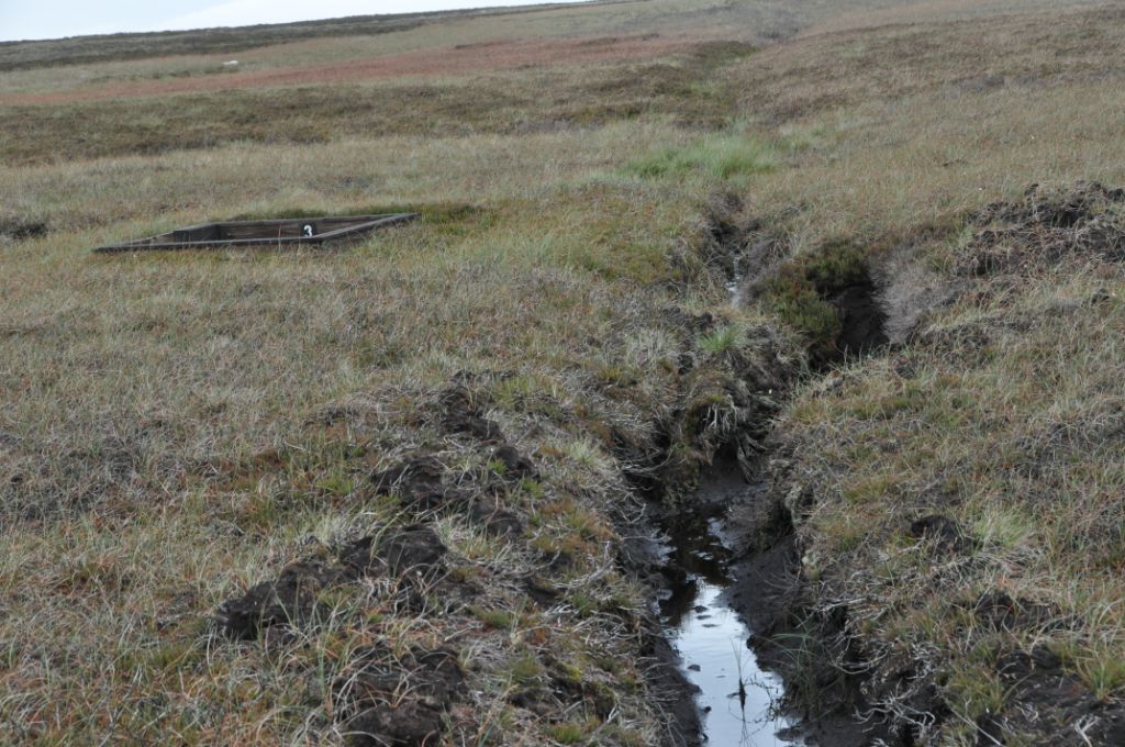
Is this a track? Another cock-up by the Ordnance Survey because it’s not marked on the maps? Try SD 951345Same track as above – if it is a track rather than a mirage.
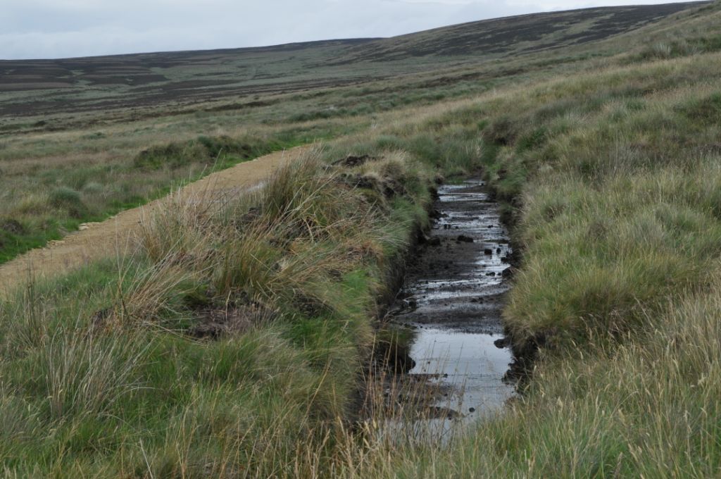
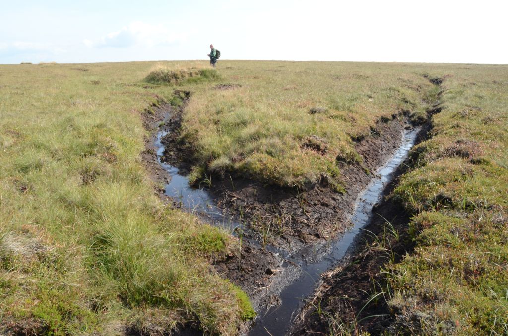
A drainage ditch at around SD 955350.
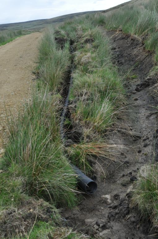
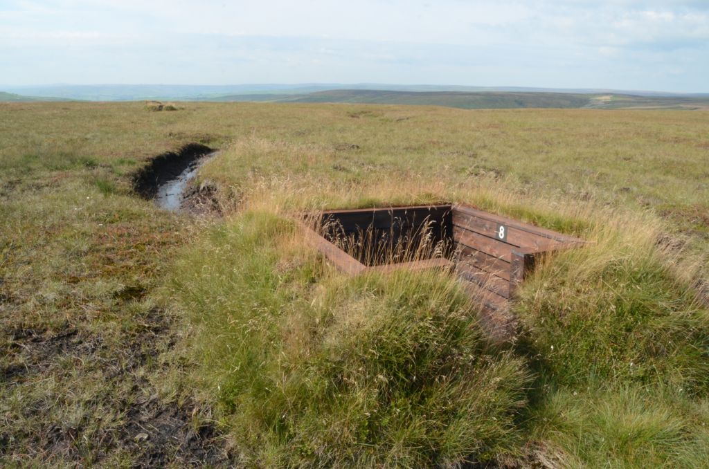
A moorland grip (drainage channel) adjacent to a sunken grouse butt.
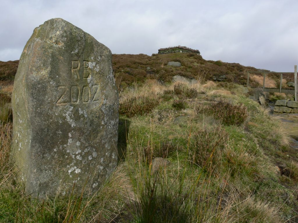
Why are the initials of the Biodiversity Minister on this stone? Or are they the proud initials of the owner of Walshaw Moor?
Attractive drainage ditch near a grouse butt.Attractive view over the moorland – and a grouse butt and a large drainage channel
[registration_form]
43 Replies to “Wuthering Moors 38 – some more photos”
Mark,
For me this is where the blogs is great. Because you can investigate things which Ngo’s are too frightened
will scare away members and upset business interests. It really angers me that people can build roads across SSSI’s and not get punished. The stuff they’ve done will probably affect the site permanentley. Imagine the amount of fuss if someone knocked down a grade listed building to make a road or a supermarket. But when its a green site its wasted ‘pontential’ that needs another department store to ‘reconnect the community” and ‘bring new business interests’ to the town. Land that is not being used for the sake of people is not valuable.
A guide to what’s really important:
How many will sign the Walshaw Moor e-petition?
Trimbush,
The reason we have a whole load of wildlife laws going back 60 years is because Society believes that the protection of the environment is important. Society has spoken on these matters, what is missing is the will do something about it by the people who are supposed to acting on the behalf of Society. I am a tax payer, and I do not feel I am getting value for money, for my taxes from Defra, NE or the Government.
I (too) am a tax payer, and I do not feel I am getting value for money, for my taxes from Defra, NE (FERA) or the Government.
60 years ago – more folk were in touch with (and understood) Mother Nature – even the RSPCA wasn’t against fox hunting
But (I think) you miss my point – too anxious to attack! Too keen to confront! Typical “conservationist”
My point is – Which (Badger TB or Walshaw Moor) is the more “important” – which will get 300,000 clicks – and how many would WM get?
We both (indeed all) know the answer!
And by the way – there is no such thing as “Society”
I am not sure what a typical conservationist is and I am pretty sure I would not be classed as a typical conservationist if such a stereotype existed. It is an easy charge to make I suppose.
The point is surely that damaging and destroying globally rare habitats is a nature conservation issue. The control of badgers in this instance is not about nature conservation. It appears to me that the number of clicks is being driven by a range of beliefs but if you asked most people if they thought protecting the environment was important, most surveys that I am aware of give a pretty high “yes” response.
I guess whilst we are there, it is worth noting that Badger TB does not exist either. It is Bovine TB in badgers.
We shall see !!
I’m sorry but back 1949, the folk in power realised that the existing regime (arrr that would be the true country run for and by true country folk…ooh arr) was simply not to be trusted with our environment and as result started to legislate for its conservation.
The ground work was started in 1940 – how is that for vision and confidence! We don’t have politicians and senior civil servants like that anymore……mind you, we don’t have smallpox either so it is not all bad.
“affect the site permanentley”
Quite right. Track topping appears to be hoggin – if so it’s a crime against geology, or at least, sense of place.
Mark am I right in thinking that if Natural England give a grant to a farmer to restore some farmland into something a bit more “natural” then there are conditions such as right of ways and no permanent structres such as hides etc and it has to have a “natural” look about it? If so what exactly has NE’s response been to the kennels. butts (hides without roofs i.m.o.) and those drainage ditches and tracks and in the previous photo’s of the carpark where I live if I left those wooden panels lying around like that I would be done for fly-tipping!
The photos are also worrying for another reason. You can quite cearly see that the grass has been chewed right down by sheep in most places. You can also see what appears to be recently burnt hills. Even without illegal persecution I would struggle to see where hen harriers would live in that barren landscape.
SD951345?
If you look at the Satellite imagery, it was surfaced sometime between 2003 and 2006 – However the presence of a track is also shown on the 1956 Ordnance Survey 1:10560 map
Do your friends call you Trigger often Mark?
kie – no, funnily enough, they don’t. Not on the 2002 OS map though? You’ll be telling me that it was a Roman road next and that the centurions came round with a few loads of hard core?
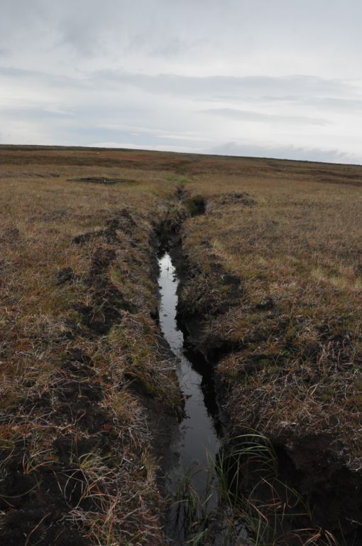
What do you think of those drainage channels?
And do you support a football team?
You keep ignoring the questions you don’t like.
Mark – I don’t know what maps you’re looking at – but I can tell you that there is a double width track quite clearly marked at that grid reference on the following:
1895-96 OS map 1:10,560 Scale
1913-15 OS map 1:10,560 Scale
1956 OS map 1:10,560 Scale
UP to date OS 1:10,000 Database
So, either the OS are lying, the satellite photo’s are lying, or you’re quite simply wrong!
kie – that’s interesting, thank you. Although, of course, we know there is a track there now because I have shown you the photograph of it, so that comes as no surprise really, does it. But the fact taht there was a track there in the quite disant past is certainly interesting, thank you.
Mark I hope you understand where I’m coming from when I say this
I fully concede that things do get done wrong, and a minority of landowners do break the rules, and again a minority kill raptors
but if people fire up the outrage bus criticising a landowner for building new tracks, and the government agencies for letting them do so – and it turns out that in fact they were acting within the rules and repairing old ones – and equally if every time a raptor dies, the immediate allegations come out, which later prove to be unfounded, then the only result is to excommunicate the shooting community.
Now, many may not like shooters for a whole variety of reasons, but the vast majority of the shooting community care passionately about conservation – we could all argue till we’re blue in the face over wetland bird species that thrive on keepered moorland (the recent reports on Curlews being a good example) but I challenge you to find anyone that has done more for, for example, black grouse or grey partridge conservation than the shooting community, given the fact that the main challenges these species face are fundamentally down to changes in agricultural and forestry practices.
So, every time you get it wrong, and (deliberately or mistakenly) cry wolf like accusing them of building new tracks, it weakens the relationship and entrenches views, and ultimately I think that working with the shooting community to mitigate the worst and promote the best, offers the best chance of conserving endangered species and habitats with a sustainable future.
kie – I don’t know who you are (because you don’t appear to have told us) so it is difficult to know where you are coming from. You did go off on a ‘Mark is just anti-shooting’ rant the day before yesterday which appeared to place you in a certain position but you can live that down over time.
I have spent years trying to work with the grouse shooting community and got nowhere. I have sometimes gone out on a limb with my own colleagues and found no movement from the shooting community on subjects such as hen harrier persecution (you brought up raptors here not me, I think). Every few years someone new comes along and says that we all have to work together – it’s a bit late to tell me that as some of us have trued that for years and years and seen raptor numbers decline through illegal activity.
And what do you think of those sunken grouse butts – you keep avoiding that subject.
Look out for more photos and more on Walshaw Moor – but not tonight.
“Is this a track? Another cock-up by the Ordnance Survey because it’s not marked on the maps? Try SD 951345″
Amazing cockup by the ordnance survey, what with them going and having it marked on the maps!
Mark, you’re really showing yourself up here!
kie – well, as you can see, because I put the link at the top of the post, there is no track shown on the 1:25,000 or 1:50,000 OS maps. They show lots of tracks – but not that one.
But, yes, thank you, you are right that the current 1:10,000 maps (copyright 2013) do show a track. Your link is to the Magic system which I hadn’t thought of looking at. Here is the link so that anyone else can http://magic.defra.gov.uk/ But we know there is a track there in 2013 – there is a photograph of it here on this post!!
It is very interesting isn’t it? Particularly if you look through the historic images. If you start with the first one (31/12/2000), and imagine that you are walking north up the track then part way, about where the current 1:25000 map stops showing a track, the track becomes far less obvious. It looks as though a hardcore track becomes a grown-over grass track. If you keep going up the ‘track’ you will find that you lose the track after a while. It is in places impossible to see on the imagery and in other places difficult to see. If you think you know it’s there then you can sometimes find it – but it’s a struggle.
Moving on in time to 31/12/2002 the same is true but even more so. Wouldn’t you agree?
And again in 32/12/2003 – it’s very difficult to see that ‘track’ ins’t it?
Let’s try the next available image, 17/7/2006 – Wow! I can see that track now!! It is, for the first time a summer image not a winter one – which might make some difference to the imagery but in every image you can (can’t you?) see the same shapes of blocks of heather (I guess) and grass (I guess) but the ‘track’ is invisible in the first three images (in some places) and then looks, in comparison, rather like a motorway in the 2006 image.
And the last image – 6 January 2009 – it still looks like a real, butch, don’t-mess-me-about track.
So, I get the impression that something pretty dramatic happened and the imagery shows it.
And what else does the imagery show? It shows some large areas at the end of the track and near the place where in 2000 it looks as though the hard core ends which aren’t marked on any map unless you’d like to point them out. Could these be car parks, turning places or what?
I recommend that anyone who wants to travel back in time on Walshaw Moor does look at the Google Earth imagery. If I were allowed I would post some examples here but I don’t think I am allowed so if you are interested enough, download Google Earth (easy and quick), find Walshaw Moor and the relevant bit of it (using Magic or Google Maps will help) and then take a walk back in time.
kie – thanks, very illuminating indeed. We must do this more often! But you keep distracting me from this book I am writing and my publisher won’t give me the second half of the advance if I don’t hand it in on 30 September so I must get on.
Surely it is irelevant when the track first appeared there just shouldn’t be a track there at all.
It’s hardly irrelevant where the key allegation being made against the estate is that they are building new tracks on the moorland. You can see how things like prosecutions could fall apart over mistakes like mark has made.
kie – whoa there! A line on a map doesn’t constitute a track on the ground. Watch this space for more on Walshaw Moor – although not for a day or two, probably.
Surley the fact that it has been recently widened and gravel laid is the most relevant thing about the track. And with the site having been Given special status due to its high levels of blanket bog, why have land owners been allowed to burn blanket bog on it? Why are there drainage ditches that will impede the further development of blanket bog due to the hydrology of the site changing? Why are there grouse butts on a site notable for wildlife? And why can you see very high levels of sheep grazing (or burning) in most places? I think that the existance of tracks on site are the least worrying. The whole management of the site is terrible for wildlife.
Looks likely that the channels will be enlarged following heavy/prolonged rain. Another flood in the making. Will they never learn?
Has anyone report these activities to the planning authority?
History tells us that this is not the first time an area of SSSI, SPA has been damaged by roads into moorland. ******* put a new road linking a forestry road up ******* Burn and Natural England did nothing as their boss at that time was a Red Grouse shooter in his spare time. This estate is next to RSPB Geltsdale and according to the Cumbrian Atlas ****** hen Harriers ********** in the 1990s. The moor is presently for sale *********!
John – I have hacked your comment around quite a lot, I’m afraid as I am not sure of the wisdom of naming some of the names. Is the Cumbrian Atlas out or do we have to wait until 2016 for it?
All,
In the previous (Wuthering Moors 37) and this blog, mention has been given as to whether the local planning authority (LPA), in this instance, Calderdale Metropolitan Borough Council (CMBC) [based on the grid references given], has been notified of the illustrated examples of grouse butts and tracks/ paths.
“…horticulture, fruit growing, seed growing, dairy farming, the breeding and keeping of livestock (including any creature kept for the production of food, wool, skins or fur, or for the purpose of its use in the farming of land), the use of land as grazing land, meadow land, osier land, market gardens and nursery grounds, and the use of land for woodlands where that use is ancillary to the farming of land for other agricultural purposes, and “agricultural” shall be construed accordingly.”.
My view is that the landowner (or who was responsible) would state that the grouse butts and tracks (whether they are new or recently maintained) fall within the exemption of Section 55 of the 1990 Act as the land is being used for the production of food (grouse to M&S perhaps?) and grazing (by sheep one would assume). Whether this is a legitimate claim, I cannot really say but it would seem to fit within the broad meaning of ‘agriculture’ as defined in planning. Perhaps a planner from CMBC would be able to confirm or refute my thoughts (I’d be happy for them to be refuted).
My text above, of course, does not preclude other legislation, for example, the Conservation of Habitats and Species Regulations 2010 which protects the European Protected Site (Special Protected Area (SPA) in this instance). As mentioned by Mark, the proposed activities were subject to an Appropriate Assessment (AA) (a legal requirement under the 2010 Regulations). The competent authority (Defra in this instance I assume) would have to be satisfied with some certainty that the changes illustrated would not effect the SPA. There is quite recent case-law (the ‘Sweetman Case’) on what constitutes ‘certainty’ in the context of loss of habitat and ‘integrity’ (see my blog on my website, dated 15th July 2013; which by the way, I didn’t think to consider the Walshaw issue). So, is there an argument that the loss of habitat within the SPA (assuming all or part of the track is within the SPA and other structures) does constitute a loss of integrity? Mark, the date that the AA was completed may be important here: was it before or after April 2013 (the date of the recent case-law I refer to)? The outcome of the case I discussed on my blog was dealing with what amounted to a little loss of habitat (0.006 % of the designated site), which the judgement concluded was sufficient to be a loss of integrity. So, would the combined area of grouse butt(s), new track (or path) and other features (including drainage) result in the SPA’s loss of integrity, especially following the judgement in the Sweetman Case.
So, in summary, I don’t think that the works required planning (but I may be wrong); but it would certainly be interesting to see the AA and how it considered integrity and certainty in light of the Sweetman Case, especially if the AA was post April 2013.
Richard
Richard – many thanks indeed.
Grouse management is not agriculture. It is the management of a wild bird population (which is why the administration of some antibiotics is slightly dubious in legal terms). My understanding is that there has been legal scrutiny of whether grouse management is agriculture (I am sure Mark is aware of this) and the legal chappies say no. It is partly this reason that prevents the licensing of the control of hen harriers. Tracks for grouse management certainly require planning permission but many planning authorities seem a bit slack or uncertain about this. Not sure about grouse butts though – could be argued that these are only temporary structures.
It is also worth bearing in mind that an existing right of way or path on blanket bog is different from a vehicle track. On Walshaw, they have a history of creating vehicle tracks where previously there were none – and the estate was successfully prosecuted for doing this a few years ago. NE recently carried out an evidence review and tracks was one of the subjects. Worth a look for those who are interested in these things – a little dry for my tastes but perhaps these things have to be. There is little doubt that a range of unconsented activities has been carried out on the Walshaw Estate, whether it be the construction of tracks, butts or drainage channels. The question is whether this type of activity should be allowed or not. The evidence review will at least inform at why we should be concerned.
Kie,
It would be nice to think that it was just a minority of landowners that persecuted birds of prey (in the uplands at least). However, as whole populations are being effected (hen harriers and peregrine), it seems unlikely to be the result of a few rogue individuals.
Oh Bertie! – my understanding is that grosue management is not agriculture and nor is pheasant shooting but I would bow to others with more experience. If pheasants or grouse were livestock then they would have to be cossetted of course!
The burning review is also very interesting and makes me think we are all looking at the wrong aspects of the management of this moor.
The Habitats regulations remove the permitted development rights that farmers and foresters etc normally rely on.
Mark & Oh Bertie,
Note that Section 336 of the Town and Country Planning Act 1990 includes ‘livestock’ within the meaning of ‘agriculture’.
Section 27 of the Wildife and Countryside Act 1981 defines ‘livestock’ as:
“…any animal which is kept for the provision of food, wool, skins or fur; for the purpose of its use in the carrying on of any agricultural activity; or for the provision or improvement of shooting or fishing;”…
So, based on this, I would infer that grouse and pheasant (for that matter) and the land for which they are managed, would fall within the meaning of ‘agriculture’ in the context of planning. This is why the licence to destroy buzzard nests was permissable under Section 16(3)(h) of the 1981 Act in order for the Estate to protect livestock (pheasants) from buzzard predation (I’m not arguing for or against the merits of this here, just stating the facts as I understand them).
Mark, if your understanding differs from this, I’d be interested to know.
Just to be clear, I’m not advocating any support for the alleged actions undertaken on Walshaw Moor; just providing my insight and understanding on the law in this regard as an ecologist who takes a great deal of interest in this area.
Richard
Richard
Richard – thank you. My understanding (which is not expertise) would be that neither pheasants nor grouse are ‘kept’. Grouse at any time, and pheasants post-release (if they are reared) can fly away. They don’t have to stay on Walshaw moor or any other moor.
Pheasants in release pens are ‘kept’. Does that mean that they are livestock whilst in the pen and then aren’t once they are released? I bet there are laws about releasing livestock into the big bad scary world – so this is quite interesting.
There must be people out there who have looked hard at this subject – maybe some of the GWCT supporters who keep an eye on this blog might enlighten us?
Richard, you are right, there is an inconsistency. Don’t know enough about the buzzard stuff but hen harrier also receives protection under European law and this is probably a factor. If there are any legal types reading this it would be good to get a view.
Never thought for a minute that you were defending the opposition and for the record, I have no issue with people wanting to shoot grouse (unlike many reading this blog I suspect). I take issue with the environmental damage that is carried out in the process of managing driven grouse shooting. If the industry got its act together (and there are less than 150 landowners in England), I would happily direct my interest elsewhere.
On reflection, reference to my comment (at 10:20am), I guess it will fall down to what is meant by ‘kept’ in terms of livestock. As pheasants are supplementary fed and medicinal grit is put down for red grouse (despite it being a wild bird), is this ‘kept’?
Pheasants are kept. I await the imminent release of squillions of the barely pheathered ph*cks, fresh from the rearing pens where they have been grown on after delivery from a hatchery. Once dumped out of their crates they will stand around on farm tracks and eat wheat from oildrum feeders, until they are driven by a gang of blokes flapping fertiliser sacks nailed to sticks into the path of a gang of knobheads with guns who will deliver barrages that Monty would have been pleased with until, replete with hearty lunch and punch, they drive off in a convoy of Chelsea Tractors back to their spouses bearing previously plucked, drawn and cling-film wrapped corpses as their reward for the day.
In a few weeks the depleted numbers will be re-stocked and the whole process starts again. The “Guns” merely perform the function of the slaughterman. What happens to the surplus of corpses I have no idea – who would bother to clean and gut them when they are so worthless that nobody bothers to poach them?
Is it kept?
We have Game Keepers – don’t we?
So we also have for example lapwing (etc) keepers – folk who create and help maintain (or at least minimise negative impact on) the(ir) ‘environment’ – temporarily or permanently – you don’t have to feed or house them as one does a ‘kept woman’.
Filbert’s outburst against the hoi polloi and rif-et-raf is amusing.
Even if there wasn’t the threat of persecution by landowners after a lot of research it seems that a lot of misguided management techniques by conservation NGO’s are from when being handed reserves by previous landowners, have seen the intensive management with sheep grazing and bog burning with no vegatation and decided that that must be the landscape valuavle to wildlife and carried on with it. Lots of reserve wardens are told to stop vegation from establishing on reserves because of the publics false mental image of moorland due to grouse keeping. Bare windswept hillsides due to sheep grazing.
Well Bingley Magistrates certainly thought there was a case against them in 2005. So what’s different this time? Friends in high places perhaps?
Pasted from Planning Portal:
“A landowner has been fined £16,500 and ordered to pay £17,026 after causing damage to moorland habitat in the South Pennine Moors Site of Special Scientific Interest.
Walshaw Moor Estate Ltd pleaded guilty at Keighley Magistrates’ Court, Bingley to three offences relating to track building and dumping material on a grouse moor in West Yorkshire.
The prosecution was brought by English Nature, the government’s wildlife protection advisor. The site is internationally protected for its blanket bog, heather moorland and breeding bird populations including merlin, golden plover and short-eared owl.
The partially completed track which prompted action by English Nature is 2.3 kilometres long and cuts through blanket bog and wet and dry heath habitats on Wadsworth Moor, north of Hebden Bridge.
On a separate part of the estate rock and soil was dumped on around 1,225 square metres of moorland habitat.
The magistrates also made orders that restoration work will have to be carried out at the estate’s expense under the supervision of English Nature.
English Nature’s Dr Andy Clements said: “We are always saddened by having to bring prosecutions as it means that some of England’s most important wildlife has already been lost or damaged. The dumping and construction of tracks in this manner and without English Nature’s consent has caused significant damage to this nationally and internationally important site.”
Peter – that’s all past history of course. And there may well be very significant differences between the past and the recent present. It would be good if we knew what they were.
Comments are closed.
This website uses cookies to improve your experience. We'll assume you're ok with this, but you can opt-out if you wish.AcceptRejectRead More
Privacy & Cookies Policy
Privacy Overview
This website uses cookies to improve your experience while you navigate through the website. Out of these, the cookies that are categorized as necessary are stored on your browser as they are essential for the working of basic functionalities of the website. We also use third-party cookies that help us analyze and understand how you use this website. These cookies will be stored in your browser only with your consent. You also have the option to opt-out of these cookies. But opting out of some of these cookies may affect your browsing experience.
Necessary cookies are absolutely essential for the website to function properly. This category only includes cookies that ensures basic functionalities and security features of the website. These cookies do not store any personal information.
Any cookies that may not be particularly necessary for the website to function and is used specifically to collect user personal data via analytics, ads, other embedded contents are termed as non-necessary cookies. It is mandatory to procure user consent prior to running these cookies on your website.
Mark,
For me this is where the blogs is great. Because you can investigate things which Ngo’s are too frightened
will scare away members and upset business interests. It really angers me that people can build roads across SSSI’s and not get punished. The stuff they’ve done will probably affect the site permanentley. Imagine the amount of fuss if someone knocked down a grade listed building to make a road or a supermarket. But when its a green site its wasted ‘pontential’ that needs another department store to ‘reconnect the community” and ‘bring new business interests’ to the town. Land that is not being used for the sake of people is not valuable.
A guide to what’s really important:
How many will sign the Walshaw Moor e-petition?
Trimbush,
The reason we have a whole load of wildlife laws going back 60 years is because Society believes that the protection of the environment is important. Society has spoken on these matters, what is missing is the will do something about it by the people who are supposed to acting on the behalf of Society. I am a tax payer, and I do not feel I am getting value for money, for my taxes from Defra, NE or the Government.
I (too) am a tax payer, and I do not feel I am getting value for money, for my taxes from Defra, NE (FERA) or the Government.
60 years ago – more folk were in touch with (and understood) Mother Nature – even the RSPCA wasn’t against fox hunting
But (I think) you miss my point – too anxious to attack! Too keen to confront! Typical “conservationist”
My point is – Which (Badger TB or Walshaw Moor) is the more “important” – which will get 300,000 clicks – and how many would WM get?
We both (indeed all) know the answer!
And by the way – there is no such thing as “Society”
I am not sure what a typical conservationist is and I am pretty sure I would not be classed as a typical conservationist if such a stereotype existed. It is an easy charge to make I suppose.
The point is surely that damaging and destroying globally rare habitats is a nature conservation issue. The control of badgers in this instance is not about nature conservation. It appears to me that the number of clicks is being driven by a range of beliefs but if you asked most people if they thought protecting the environment was important, most surveys that I am aware of give a pretty high “yes” response.
I guess whilst we are there, it is worth noting that Badger TB does not exist either. It is Bovine TB in badgers.
We shall see !!
I’m sorry but back 1949, the folk in power realised that the existing regime (arrr that would be the true country run for and by true country folk…ooh arr) was simply not to be trusted with our environment and as result started to legislate for its conservation.
The ground work was started in 1940 – how is that for vision and confidence! We don’t have politicians and senior civil servants like that anymore……mind you, we don’t have smallpox either so it is not all bad.
“affect the site permanentley”
Quite right. Track topping appears to be hoggin – if so it’s a crime against geology, or at least, sense of place.
Mark am I right in thinking that if Natural England give a grant to a farmer to restore some farmland into something a bit more “natural” then there are conditions such as right of ways and no permanent structres such as hides etc and it has to have a “natural” look about it? If so what exactly has NE’s response been to the kennels. butts (hides without roofs i.m.o.) and those drainage ditches and tracks and in the previous photo’s of the carpark where I live if I left those wooden panels lying around like that I would be done for fly-tipping!
The photos are also worrying for another reason. You can quite cearly see that the grass has been chewed right down by sheep in most places. You can also see what appears to be recently burnt hills. Even without illegal persecution I would struggle to see where hen harriers would live in that barren landscape.
SD951345?
If you look at the Satellite imagery, it was surfaced sometime between 2003 and 2006 – However the presence of a track is also shown on the 1956 Ordnance Survey 1:10560 map
Do your friends call you Trigger often Mark?
kie – no, funnily enough, they don’t. Not on the 2002 OS map though? You’ll be telling me that it was a Roman road next and that the centurions came round with a few loads of hard core?
What do you think of those drainage channels?
And do you support a football team?
You keep ignoring the questions you don’t like.
Mark – I don’t know what maps you’re looking at – but I can tell you that there is a double width track quite clearly marked at that grid reference on the following:
1895-96 OS map 1:10,560 Scale
1913-15 OS map 1:10,560 Scale
1956 OS map 1:10,560 Scale
UP to date OS 1:10,000 Database
So, either the OS are lying, the satellite photo’s are lying, or you’re quite simply wrong!
kie – that’s interesting, thank you. Although, of course, we know there is a track there now because I have shown you the photograph of it, so that comes as no surprise really, does it. But the fact taht there was a track there in the quite disant past is certainly interesting, thank you.
Mark I hope you understand where I’m coming from when I say this
I fully concede that things do get done wrong, and a minority of landowners do break the rules, and again a minority kill raptors
but if people fire up the outrage bus criticising a landowner for building new tracks, and the government agencies for letting them do so – and it turns out that in fact they were acting within the rules and repairing old ones – and equally if every time a raptor dies, the immediate allegations come out, which later prove to be unfounded, then the only result is to excommunicate the shooting community.
Now, many may not like shooters for a whole variety of reasons, but the vast majority of the shooting community care passionately about conservation – we could all argue till we’re blue in the face over wetland bird species that thrive on keepered moorland (the recent reports on Curlews being a good example) but I challenge you to find anyone that has done more for, for example, black grouse or grey partridge conservation than the shooting community, given the fact that the main challenges these species face are fundamentally down to changes in agricultural and forestry practices.
So, every time you get it wrong, and (deliberately or mistakenly) cry wolf like accusing them of building new tracks, it weakens the relationship and entrenches views, and ultimately I think that working with the shooting community to mitigate the worst and promote the best, offers the best chance of conserving endangered species and habitats with a sustainable future.
kie – I don’t know who you are (because you don’t appear to have told us) so it is difficult to know where you are coming from. You did go off on a ‘Mark is just anti-shooting’ rant the day before yesterday which appeared to place you in a certain position but you can live that down over time.
I have spent years trying to work with the grouse shooting community and got nowhere. I have sometimes gone out on a limb with my own colleagues and found no movement from the shooting community on subjects such as hen harrier persecution (you brought up raptors here not me, I think). Every few years someone new comes along and says that we all have to work together – it’s a bit late to tell me that as some of us have trued that for years and years and seen raptor numbers decline through illegal activity.
And what do you think of those sunken grouse butts – you keep avoiding that subject.
Look out for more photos and more on Walshaw Moor – but not tonight.
“Is this a track? Another cock-up by the Ordnance Survey because it’s not marked on the maps? Try SD 951345″
See here:
http://oi43.tinypic.com/2uy6akn.jpg
Amazing cockup by the ordnance survey, what with them going and having it marked on the maps!
Mark, you’re really showing yourself up here!
kie – well, as you can see, because I put the link at the top of the post, there is no track shown on the 1:25,000 or 1:50,000 OS maps. They show lots of tracks – but not that one.
But, yes, thank you, you are right that the current 1:10,000 maps (copyright 2013) do show a track. Your link is to the Magic system which I hadn’t thought of looking at. Here is the link so that anyone else can http://magic.defra.gov.uk/ But we know there is a track there in 2013 – there is a photograph of it here on this post!!
But I did have a look at the imagery on GoogleEarth http://www.google.com/earth/index.html
It is very interesting isn’t it? Particularly if you look through the historic images. If you start with the first one (31/12/2000), and imagine that you are walking north up the track then part way, about where the current 1:25000 map stops showing a track, the track becomes far less obvious. It looks as though a hardcore track becomes a grown-over grass track. If you keep going up the ‘track’ you will find that you lose the track after a while. It is in places impossible to see on the imagery and in other places difficult to see. If you think you know it’s there then you can sometimes find it – but it’s a struggle.
Moving on in time to 31/12/2002 the same is true but even more so. Wouldn’t you agree?
And again in 32/12/2003 – it’s very difficult to see that ‘track’ ins’t it?
Let’s try the next available image, 17/7/2006 – Wow! I can see that track now!! It is, for the first time a summer image not a winter one – which might make some difference to the imagery but in every image you can (can’t you?) see the same shapes of blocks of heather (I guess) and grass (I guess) but the ‘track’ is invisible in the first three images (in some places) and then looks, in comparison, rather like a motorway in the 2006 image.
And the last image – 6 January 2009 – it still looks like a real, butch, don’t-mess-me-about track.
So, I get the impression that something pretty dramatic happened and the imagery shows it.
And what else does the imagery show? It shows some large areas at the end of the track and near the place where in 2000 it looks as though the hard core ends which aren’t marked on any map unless you’d like to point them out. Could these be car parks, turning places or what?
I recommend that anyone who wants to travel back in time on Walshaw Moor does look at the Google Earth imagery. If I were allowed I would post some examples here but I don’t think I am allowed so if you are interested enough, download Google Earth (easy and quick), find Walshaw Moor and the relevant bit of it (using Magic or Google Maps will help) and then take a walk back in time.
kie – thanks, very illuminating indeed. We must do this more often! But you keep distracting me from this book I am writing and my publisher won’t give me the second half of the advance if I don’t hand it in on 30 September so I must get on.
Surely it is irelevant when the track first appeared there just shouldn’t be a track there at all.
It’s hardly irrelevant where the key allegation being made against the estate is that they are building new tracks on the moorland. You can see how things like prosecutions could fall apart over mistakes like mark has made.
kie – whoa there! A line on a map doesn’t constitute a track on the ground. Watch this space for more on Walshaw Moor – although not for a day or two, probably.
Surley the fact that it has been recently widened and gravel laid is the most relevant thing about the track. And with the site having been Given special status due to its high levels of blanket bog, why have land owners been allowed to burn blanket bog on it? Why are there drainage ditches that will impede the further development of blanket bog due to the hydrology of the site changing? Why are there grouse butts on a site notable for wildlife? And why can you see very high levels of sheep grazing (or burning) in most places? I think that the existance of tracks on site are the least worrying. The whole management of the site is terrible for wildlife.
Looks likely that the channels will be enlarged following heavy/prolonged rain. Another flood in the making. Will they never learn?
Has anyone report these activities to the planning authority?
History tells us that this is not the first time an area of SSSI, SPA has been damaged by roads into moorland. ******* put a new road linking a forestry road up ******* Burn and Natural England did nothing as their boss at that time was a Red Grouse shooter in his spare time. This estate is next to RSPB Geltsdale and according to the Cumbrian Atlas ****** hen Harriers ********** in the 1990s. The moor is presently for sale *********!
John – I have hacked your comment around quite a lot, I’m afraid as I am not sure of the wisdom of naming some of the names. Is the Cumbrian Atlas out or do we have to wait until 2016 for it?
All,
In the previous (Wuthering Moors 37) and this blog, mention has been given as to whether the local planning authority (LPA), in this instance, Calderdale Metropolitan Borough Council (CMBC) [based on the grid references given], has been notified of the illustrated examples of grouse butts and tracks/ paths.
Readers should be aware that under Section 55 of the Town and Country Planning Act 1990 (see http://www.legislation.gov.uk/ukpga/1990/8/section/55), certain agriculture practices are not considered ‘development’ and therefore, MAY not require planning permission. Agriculture is defined under Section 336 of the 1990 Act (see http://www.legislation.gov.uk/ukpga/1990/8/section/336) as:
“…horticulture, fruit growing, seed growing, dairy farming, the breeding and keeping of livestock (including any creature kept for the production of food, wool, skins or fur, or for the purpose of its use in the farming of land), the use of land as grazing land, meadow land, osier land, market gardens and nursery grounds, and the use of land for woodlands where that use is ancillary to the farming of land for other agricultural purposes, and “agricultural” shall be construed accordingly.”.
My view is that the landowner (or who was responsible) would state that the grouse butts and tracks (whether they are new or recently maintained) fall within the exemption of Section 55 of the 1990 Act as the land is being used for the production of food (grouse to M&S perhaps?) and grazing (by sheep one would assume). Whether this is a legitimate claim, I cannot really say but it would seem to fit within the broad meaning of ‘agriculture’ as defined in planning. Perhaps a planner from CMBC would be able to confirm or refute my thoughts (I’d be happy for them to be refuted).
My text above, of course, does not preclude other legislation, for example, the Conservation of Habitats and Species Regulations 2010 which protects the European Protected Site (Special Protected Area (SPA) in this instance). As mentioned by Mark, the proposed activities were subject to an Appropriate Assessment (AA) (a legal requirement under the 2010 Regulations). The competent authority (Defra in this instance I assume) would have to be satisfied with some certainty that the changes illustrated would not effect the SPA. There is quite recent case-law (the ‘Sweetman Case’) on what constitutes ‘certainty’ in the context of loss of habitat and ‘integrity’ (see my blog on my website, dated 15th July 2013; which by the way, I didn’t think to consider the Walshaw issue). So, is there an argument that the loss of habitat within the SPA (assuming all or part of the track is within the SPA and other structures) does constitute a loss of integrity? Mark, the date that the AA was completed may be important here: was it before or after April 2013 (the date of the recent case-law I refer to)? The outcome of the case I discussed on my blog was dealing with what amounted to a little loss of habitat (0.006 % of the designated site), which the judgement concluded was sufficient to be a loss of integrity. So, would the combined area of grouse butt(s), new track (or path) and other features (including drainage) result in the SPA’s loss of integrity, especially following the judgement in the Sweetman Case.
So, in summary, I don’t think that the works required planning (but I may be wrong); but it would certainly be interesting to see the AA and how it considered integrity and certainty in light of the Sweetman Case, especially if the AA was post April 2013.
Richard
Richard – many thanks indeed.
Grouse management is not agriculture. It is the management of a wild bird population (which is why the administration of some antibiotics is slightly dubious in legal terms). My understanding is that there has been legal scrutiny of whether grouse management is agriculture (I am sure Mark is aware of this) and the legal chappies say no. It is partly this reason that prevents the licensing of the control of hen harriers. Tracks for grouse management certainly require planning permission but many planning authorities seem a bit slack or uncertain about this. Not sure about grouse butts though – could be argued that these are only temporary structures.
It is also worth bearing in mind that an existing right of way or path on blanket bog is different from a vehicle track. On Walshaw, they have a history of creating vehicle tracks where previously there were none – and the estate was successfully prosecuted for doing this a few years ago. NE recently carried out an evidence review and tracks was one of the subjects. Worth a look for those who are interested in these things – a little dry for my tastes but perhaps these things have to be. There is little doubt that a range of unconsented activities has been carried out on the Walshaw Estate, whether it be the construction of tracks, butts or drainage channels. The question is whether this type of activity should be allowed or not. The evidence review will at least inform at why we should be concerned.
Kie,
It would be nice to think that it was just a minority of landowners that persecuted birds of prey (in the uplands at least). However, as whole populations are being effected (hen harriers and peregrine), it seems unlikely to be the result of a few rogue individuals.
Oh Bertie! – my understanding is that grosue management is not agriculture and nor is pheasant shooting but I would bow to others with more experience. If pheasants or grouse were livestock then they would have to be cossetted of course!
Mark,
It occurred to me that folk may be interested in the link to the evidence review:
http://www.naturalengland.org.uk/ourwork/uplands/default.aspx
The burning review is also very interesting and makes me think we are all looking at the wrong aspects of the management of this moor.
The Habitats regulations remove the permitted development rights that farmers and foresters etc normally rely on.
Mark & Oh Bertie,
Note that Section 336 of the Town and Country Planning Act 1990 includes ‘livestock’ within the meaning of ‘agriculture’.
Section 27 of the Wildife and Countryside Act 1981 defines ‘livestock’ as:
“…any animal which is kept for the provision of food, wool, skins or fur; for the purpose of its use in the carrying on of any agricultural activity; or for the provision or improvement of shooting or fishing;”…
So, based on this, I would infer that grouse and pheasant (for that matter) and the land for which they are managed, would fall within the meaning of ‘agriculture’ in the context of planning. This is why the licence to destroy buzzard nests was permissable under Section 16(3)(h) of the 1981 Act in order for the Estate to protect livestock (pheasants) from buzzard predation (I’m not arguing for or against the merits of this here, just stating the facts as I understand them).
Mark, if your understanding differs from this, I’d be interested to know.
Just to be clear, I’m not advocating any support for the alleged actions undertaken on Walshaw Moor; just providing my insight and understanding on the law in this regard as an ecologist who takes a great deal of interest in this area.
Richard
Richard
Richard – thank you. My understanding (which is not expertise) would be that neither pheasants nor grouse are ‘kept’. Grouse at any time, and pheasants post-release (if they are reared) can fly away. They don’t have to stay on Walshaw moor or any other moor.
Pheasants in release pens are ‘kept’. Does that mean that they are livestock whilst in the pen and then aren’t once they are released? I bet there are laws about releasing livestock into the big bad scary world – so this is quite interesting.
There must be people out there who have looked hard at this subject – maybe some of the GWCT supporters who keep an eye on this blog might enlighten us?
Richard, you are right, there is an inconsistency. Don’t know enough about the buzzard stuff but hen harrier also receives protection under European law and this is probably a factor. If there are any legal types reading this it would be good to get a view.
Never thought for a minute that you were defending the opposition and for the record, I have no issue with people wanting to shoot grouse (unlike many reading this blog I suspect). I take issue with the environmental damage that is carried out in the process of managing driven grouse shooting. If the industry got its act together (and there are less than 150 landowners in England), I would happily direct my interest elsewhere.
On reflection, reference to my comment (at 10:20am), I guess it will fall down to what is meant by ‘kept’ in terms of livestock. As pheasants are supplementary fed and medicinal grit is put down for red grouse (despite it being a wild bird), is this ‘kept’?
Pheasants are kept. I await the imminent release of squillions of the barely pheathered ph*cks, fresh from the rearing pens where they have been grown on after delivery from a hatchery. Once dumped out of their crates they will stand around on farm tracks and eat wheat from oildrum feeders, until they are driven by a gang of blokes flapping fertiliser sacks nailed to sticks into the path of a gang of knobheads with guns who will deliver barrages that Monty would have been pleased with until, replete with hearty lunch and punch, they drive off in a convoy of Chelsea Tractors back to their spouses bearing previously plucked, drawn and cling-film wrapped corpses as their reward for the day.
In a few weeks the depleted numbers will be re-stocked and the whole process starts again. The “Guns” merely perform the function of the slaughterman. What happens to the surplus of corpses I have no idea – who would bother to clean and gut them when they are so worthless that nobody bothers to poach them?
Is it kept?
We have Game Keepers – don’t we?
So we also have for example lapwing (etc) keepers – folk who create and help maintain (or at least minimise negative impact on) the(ir) ‘environment’ – temporarily or permanently – you don’t have to feed or house them as one does a ‘kept woman’.
Filbert’s outburst against the hoi polloi and rif-et-raf is amusing.
Even if there wasn’t the threat of persecution by landowners after a lot of research it seems that a lot of misguided management techniques by conservation NGO’s are from when being handed reserves by previous landowners, have seen the intensive management with sheep grazing and bog burning with no vegatation and decided that that must be the landscape valuavle to wildlife and carried on with it. Lots of reserve wardens are told to stop vegation from establishing on reserves because of the publics false mental image of moorland due to grouse keeping. Bare windswept hillsides due to sheep grazing.
Well Bingley Magistrates certainly thought there was a case against them in 2005. So what’s different this time? Friends in high places perhaps?
Pasted from Planning Portal:
“A landowner has been fined £16,500 and ordered to pay £17,026 after causing damage to moorland habitat in the South Pennine Moors Site of Special Scientific Interest.
Walshaw Moor Estate Ltd pleaded guilty at Keighley Magistrates’ Court, Bingley to three offences relating to track building and dumping material on a grouse moor in West Yorkshire.
The prosecution was brought by English Nature, the government’s wildlife protection advisor. The site is internationally protected for its blanket bog, heather moorland and breeding bird populations including merlin, golden plover and short-eared owl.
The partially completed track which prompted action by English Nature is 2.3 kilometres long and cuts through blanket bog and wet and dry heath habitats on Wadsworth Moor, north of Hebden Bridge.
On a separate part of the estate rock and soil was dumped on around 1,225 square metres of moorland habitat.
The magistrates also made orders that restoration work will have to be carried out at the estate’s expense under the supervision of English Nature.
English Nature’s Dr Andy Clements said: “We are always saddened by having to bring prosecutions as it means that some of England’s most important wildlife has already been lost or damaged. The dumping and construction of tracks in this manner and without English Nature’s consent has caused significant damage to this nationally and internationally important site.”
Peter – that’s all past history of course. And there may well be very significant differences between the past and the recent present. It would be good if we knew what they were.