
Nick MacKinnon is a freelance teacher of Maths, English and Medieval History, and lives above Haworth, in the last inhabited house before Top Withens = Wuthering Heights. In 1992 he founded the successful Campaign to Save Radio 4 Long Wave while in plaster following a rock-climbing accident on Skye. His poem ‘The metric system’ won the 2013 Forward Prize. His topical verse and satire appears in the Spectator, and his puzzles and problems in the Sunday Times and American Mathematical Monthly. Email: nipmackinnon@gmail.com
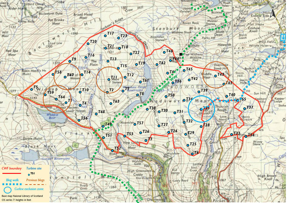
Turbine 35: Flaight Hill SD 988 332, what3words ///midwinter.undulation.civic
9 February 2024 Group Captain James Stagg didn’t have a weather app on his mobile phone but was able to tell General Eisenhower that June 5 would be too windy for my father’s first trip abroad. On July 9, still aged 17, Dad saw “the sky black from horizon to horizon with bombers” at Caen, before being shot. He was training for a glider assault on the paddy fields of mainland Japan when the war ended. I have his Penguin Hiroshima (John Hersey) which he thought described the price of his own survival; and Crime and Punishment, read by the coal fire in the Spitalfields police section house. His review is the best of any book I know: “There’s a boy walking in the dark with an axe under his long coat, and I think, “O my God, he’s going to kill the old woman!”
My app forecast yesterday’s big dump of snow a week ago, but also today’s big thaw. I am hoping the secret Bannister track around the backwards question mark of CWF will be skiable, but at Lee Shaw reservoir yellow meltwater is already pouring down the ruts of Bodkin Lane.
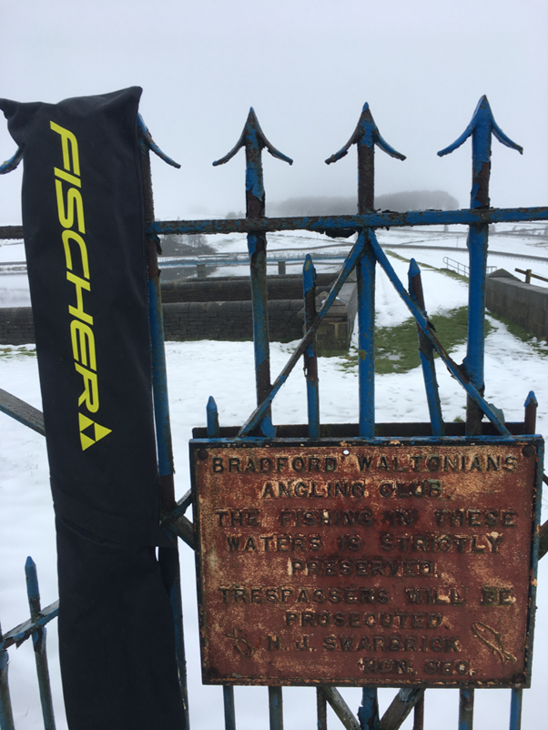
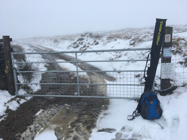
Had I placed my ski-bag less ostentatiously you might have seen the divine summer house or ‘valve-shaft housing’ on the outlet tower. It’s so murky I can’t decide whether it’s eight or ten-sided, but it reminds us of a time when our civic infrastructure had style because it was ours. The gate’s circular arcs are Oxenhope pattern, which stops someone from Haworth filling their gap with your gate like a sink plug in the Soviet Union. There is a splendid iron sign, cast in sand by some forgotten Keighley foundry.
BRADFORD WALTONIANS ANGLING CLUB. THE FISHING IN THESE WATERS IS STRICTLY PRESERVED. TRESPASSERS WILL BE PROSECUTED. H.J. SWARBRICK HON. SEC.
A Canada goose is explaining Mr Swarbrick’s policy to a seagull, but otherwise nothing stirs in the fog. I mumble to myself about the mysterious Waltonians (are they a Muggletonian splinter group?) and only twigged (Isaak Walton!) after sleeping on it. Baffled, I plod up the relentless track to Top of Stairs, wearing the ski-bag like an albatross. I mull Dastardly Dick Bannister’s scoping application prepared by his consultant Muttley for a reported £4 million (wheezy snicker).
The dog that didn’t bark in response to scoping is Yorkshire Water, who are more intimately entangled with Mr Bannister than the protagonists of Hokusai’s Dream of the Fisherman’s Wife. It is inevitable that CWF’s vast disruptions to peat will affect water quality. Moors for the Future put the costs of particle removal under normal conditions at £2000 – £4000 per week per catchment. On the other hand, the land value of the YW portfolio will rocket if their 30000 hectares (thirteen CWFs) can be booked as “potential wind farm” instead of “failing grouse moor”. We won’t hear a whimper out of YW once they’ve got their £200,000 p.a. “Stick it to the man YW!” but we will be paying for this peat treatment in our electricity standing charges, and then again in our water bills. YW long for this wind farm as much as they must long to simplify the Lee Shaw valve shaft housing. Key Opportunity 8 in a sad little paper Generating Value from YW Land is “Selling gravel from our sewage farm filter beds”. Form an orderly queue. I shall be generous in my apology if YW does object, because they can kill CWF, but it would be like fishermen’s wives voting against octopuses.
Nearly all the bodies that replied to Muttley’s scoping application did so vigorously. The RSPB are withering about the inadequacy of his wacky bird work. CPRE are scathing about the bloated document when the habitat objections alone should be insuperable but pass unaddressed. Calderdale’s decision notice on 14 December is a below-the-waterline hole and Bradford Council put the boot in fair and hard. Ban-the-Burn opened up the key question of the developer’s misuse of a now completely misleading Scottish carbon calculator.
On the other hand, the National Trust “reserved their position” and I’m told Muttley will pacify the scone-mongers by graciously withdrawing T52 at Blake Dean, one of his strategic reserve of dummy turbines. The NT have denied access across Hardcastle Crags, but this is meaningless virtue signalling because getting a turbine blade from Gibson Mill up to Shackleton Knoll would be like a remake of Fitzcarraldo. The better-informed respondents need to explain the habitat and carbon complexities of wind farms on Natura 2000 peat to the NT. This isn’t about one dummy eyesore on your boundary.
The respondents note Muttley’s silence about his borrow pits (on-site mini-quarries for aggregates) and solar panels. The reason for his coyness is that he doesn’t want us to comprehend what is proposed for our moor. Here is my model of what the logic of money and site imply, and if Muttley doesn’t like mine, he really should have shown us his in scoping. This model has been greatly improved in conversation with a mole, close in counsel with Muttley, codenamed Deep Stoat.
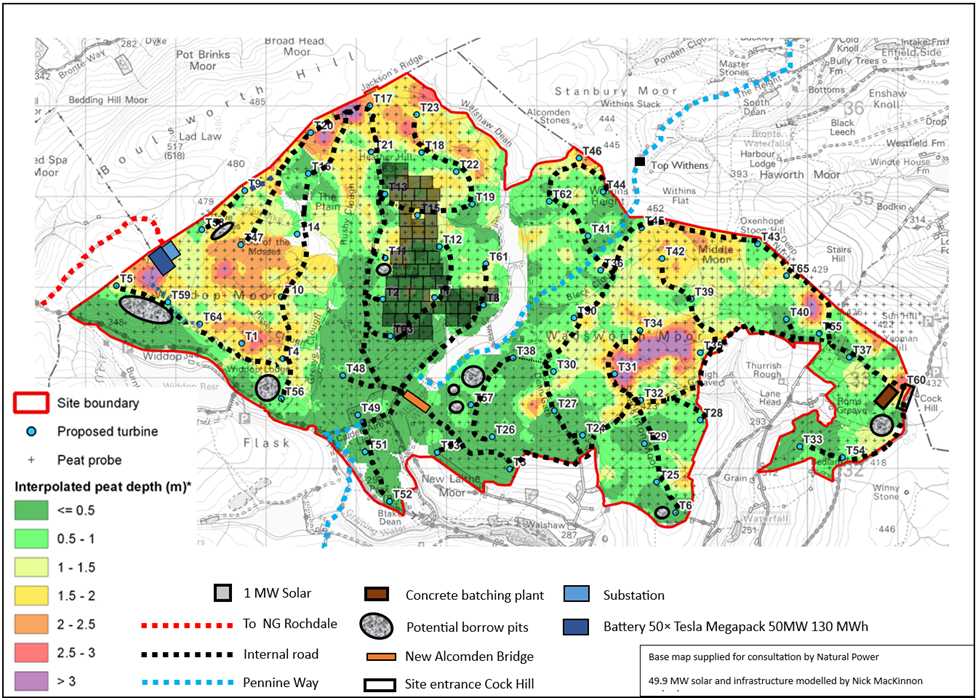
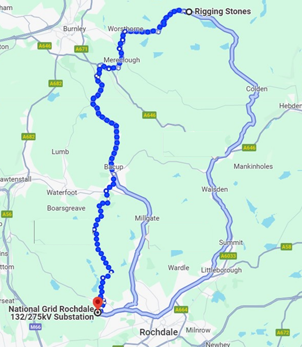
The blades and pylons will be landed at either Goole in the east or Ellsmere in the west. Access to CWF is possible from the M62 from the east and the M65 from the west. The east or west decision will be determined by the relative difficulty of the final miles, since the approaches from port to motorway exit are symmetrical. The scoping report (p90) refers to a single Site Entrance. From Ellesmere this would be on the Widdop road. From Goole it would be on the A6033 Oxenhope-Hebden Bridge road.
Anyone who has driven the precipitous, narrow, winding western end of the Widdop road knows that without huge civil works, including blasting at Hanson Fold and Rieve Edge, this is never going to be approved for fleets of tipper trucks, concrete mixers and blade delivery systems. The killing edge is protected by boulders and railings, and driving uphill at rush hour in the dark is hair-raising.
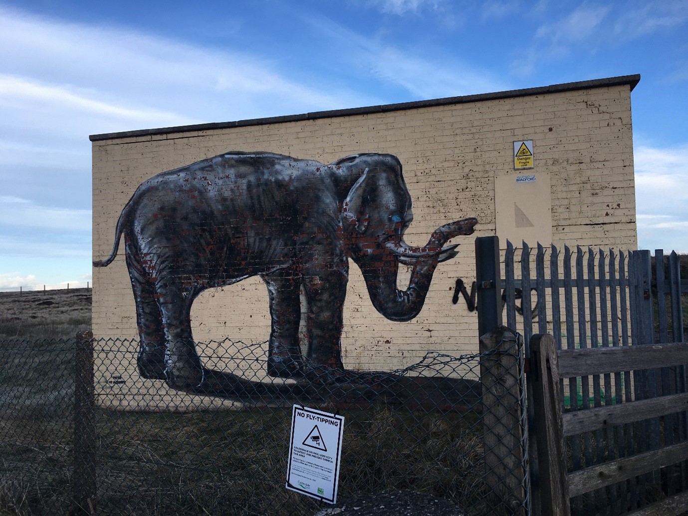
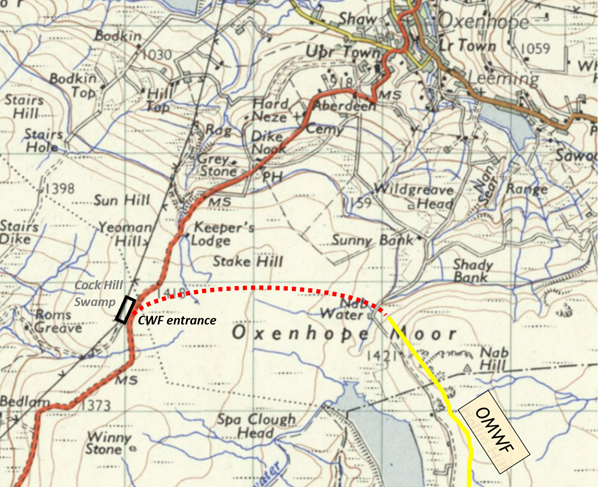
Deep Stoat told me (crucially) that ‘apart from grid cable trenching there will be no activity on the Widdop road. The sole site access will be Cock Hill Swamp on the A6033 [Oxenhope to Hebden Bridge] opposite the elephant.’
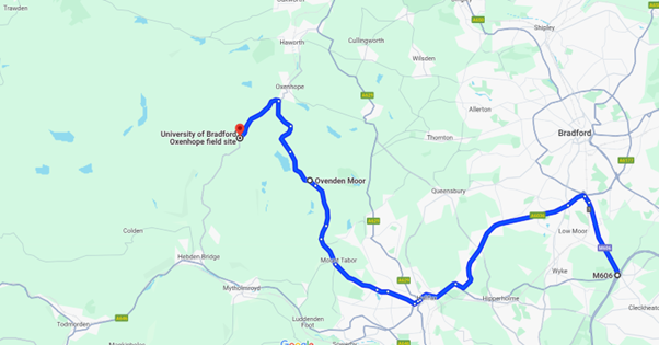
From the M62/M606 this route is almost entirely in Calderdale, which Deep Stoat calls ‘a strong planning bonus’. Note that it avoids the mazes in Oxenhope and Hebden Bridge, and their implacable residents. Only the last 5km from Ovenden Moor WF to Cock Hill Swamp is under Bradford control, which Deep Stoat observes will give the council some ‘planning leverage’ in return for ‘the mutilation of their Brontë industry’. The blade route from the M62 to Ovenden Moor WF has already been proved, and the road beyond OMWF, though single track, is manageable: only one overhead electricity cable crosses it. A better alternative would be a temporary road across Oxenhope Moor from Nab Water (SE 030 327) to Cock Hill Swamp (SE 011 327) which can be sold as “saving CO2” despite being built over the Great Peat Moss, because it cuts out a 70m ascent for what could be 12000 heavy loads and 12000 empty returns. Deep Stoat could neither confirm nor deny ‘your wholly speculative Nab Water bypass’ while admitting that he would be suggesting it to Muttley as ‘it would be easier to build than most of the internal roads in CWF’ if only because ‘it has a bloody great quarry at the live end.’
Close reading of the scoping report confirms the Cock Hill Swamp entrance. Muttley is caught in two minds about where the aggregates for the internal roads, crane hard-standings and turbine foundations are coming from. On page 90 we have “several quarries located to the east of the site” but on page 10 “Suitable volumes of stone and aggregate shall be sourced from on-site borrow pits.” I suppose the weasel words “suitable volumes” range from “none at all” to “all of it”.
The site is split by Walshaw Dean, and I shall call the halves CWF-W and CWF-E. The link between them could have been made along Jackson’s Ridge at the north, if the boundary didn’t dive into Bolt Hole in justified fear of Stanbury Bog. I don’t think Yorkshire Water can allow thousands of lorry trips over their dams, whatever the octopus says it will do for them in return, so a substantial bridge will be built near the present listed one over Alcomden Water. The roads must follow contours where possible so Greave Clough, Walshaw Dean and Mare Greave impose a north-south grain on the road system. Although the existing roads will have to upgraded for very heavy infrequent loads (crane, blades, pylons) and frequent heavy loads (concrete, rebar, Richard Bannister’s half-track) I have used their routes (the scoping report confirms this policy) including today’s ski road, even though it is not on the scoping maps. I asked Deep Stoat if any of the plans lodged with Calderdale use an accurate base map: ‘To date, all mapping that has passed under our eyes is deficient in key details’. This is terrain that Muttley claims to have probed at perfect 100m intervals. I offered Muttley’s employer Natural Power an opportunity to comment on his deficient maps (12 February 2024: no reply). I take this silence as concession that the base maps are indeed ‘deficient in key details’.
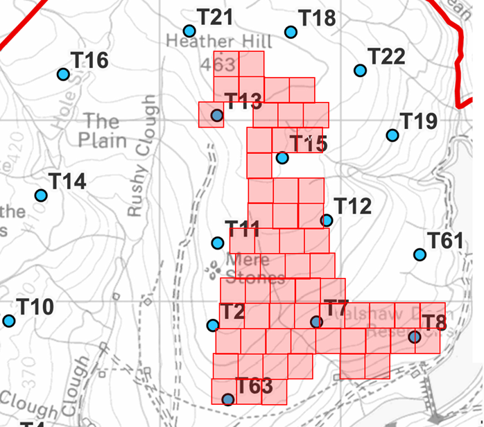
Internal roads must follow contours where possible, lest they accelerate drainage, though can’t help it when crossing Walshaw Dean. The turbine sites mostly avoid the deepest peat, so the model roads do as well. An anomaly is T47 Field of the Mosses which Deep Stoat suggests will topple second in planning, after T52 Blake Dean. T20 at the northern point is also on deep peat, but there will have to be a road around the top of Greave Clough so there might as well be a turbine site. T31 and T34 are on deep peat in CWF-E and are not on a logistical route, so may topple, but the last few turbines have a much lower marginal cost than the first few, so each turbine site will be defended like Caen.
Roads on similar wind farms are usually 5 metres wide. The green-shaded peat will be chopped out down to bedrock and a crushed rock road built up proud of the surroundings. Floating roads use deep peat as the foundation and plastic geogrid mesh to stabilise a thin rock layer and might be used across yellow-depth peat on CWF. I have walked much of this saturated peat after a wet year, and attempting a floating road seems crazy to me. Bob Berzins, met on the walk to T47 Field of the Mosses, thought they would chop down to bedrock irrespective of peat depth, but Deep Stoat says floating road sections ‘remain under consideration pending detailed on-site study of local peat shear strength, under downhill braking, through low-radius corners, and in transitions.’ In other words, ‘If the peat is likely to ruck up like a carpet when a lorry brakes, turns sharply or has its front axles on traditional and drive axles on floating, then we find bedrock’.
A borrow pit is an on-site quarry. They can be dug into edges, but smaller ones exploit outcrops, and the familiar delphs in flat millstone beds clear the surface peat and spoil and go straight down. A major problem for CWF is that the visible rock resource is in the far west, and is defended by the deepest peat, but the road system must fan out from the entry point on Cock Hill Swamp at the other end of the site. Because Walshaw Moor seems featureless (once you get your eye in it abounds in charisma) every exploitable outcrop has a name and personality. In CWF-E these are Grinnel Stones, Deer Stones, Lower Stones and Hewer Stones, all near T57. There will be be borrow pits at these small outcrops, but none solve the problem of where to get the aggregate for the roads over Cock Hill Swamp which is needed on D-Day. There is ample rock available in CWF-W in Western Hills and Great Edge Flat, and at the Dove Stones, but no roads to reach it. This chicken-or-egg problem can be solved in at least four ways.
- a) Simply dig a hole in Cock Hill Swamp down to bedrock and crunch whatever is found there for road aggregate. This would be ‘a helluva big hole’, as it must supply the road system until it reaches other more obvious borrow pits. Readers who are expert in quarrying might like to tell me where those are in CWF-E. Is Muttley really going to grind up named landscape features?
- b) Reopen Nab Hill quarry as an external borrow pit.
- c) Send a quarry team on a one-way glider trip onto the paddy fields of Crown Point Flat. They will build the main road east from big borrow pits in Western Hills and Great Edge and can then be exfiltrated at Cock Hill Swamp. A similar plan, not depending on airborne assault, would use temporary access up the track just west of CWF to the failed oil well.
- d) Bring road and foundation aggregate in from much further afield with a consequent big increase in CO2 and heavy lorry disturbance for people on the Halifax to Cock Hill Swamp route. Page 90 of the scoping report makes it clear that this possibility has been considered. The nearest working quarry is Northowram Hills.
None of these are attractive and it is no surprise that Muttley is so confused about where he’s getting his aggregates from. Deep Stoat doesn’t know either, so nobody knows, and aggregates remain a key perplexity at CWF-HQ. Perhaps Muttley will be raising a paw at the next YW auction for Lot 8: Gravel from our sewage farm filter beds.
The amount of solar is constrained by the relatively poor sunshine in the Pennines and the lack of south-facing slopes given the strong N-S grain of the site (the sides of Greave Clough, Walshaw Dean and Mares Greave all face W-E). South of Watford Gap (1500 h/yr sunshine) large solar arrays run on 1.5 ha per MW. Malham Cove has 1200 h/yr sunshine, so I have reckoned on 1.9 ha per MW in CWF. It is absurd to build a solar park in the Pennines, unless you get the grid connection, substation, battery, roads and internal cables for free with your wind farm. Exploiting free stuff puts a premium on maximising the solar, and the model shows a single array that would be nameplated at 49.9MW. Each square in the diagram is nominally 1MW. Some are facing SE which reduces power by 8%. Allowance for service roads is built in to the “1.9 ha/MW” but there will be some loss of wattage to turbine sites and turbine shadow. These reductions are balanced by there being sixty 1MW shaded squares. That this vast blot on the landscape can only be name-plated at 49.9MW (and will usually generate far less) is sufficient reason for Muttley to have kept it secret in scoping, and yet the financial imperative to maximise solar given the free overheads has still not been met. Smaller arrays in other CWF locations are possible and were this my failing grouse moor I’d be summoning Muttley to Bannister Towers to ‘pull his solar finger out’, as the late Duke of Edinburgh put it. We must remember that the developers are not in the end paying for any of this wacky solar-wind farm. We will be paying off the mortgage for the rest of our lives.
Two parallel buried 132kV cables will leave the western end for the grid at Rochdale GSP. The route is 30km and costs are of the order of £1.2 million per km, so the grid connection will add about £36 million to the mortgage. This figure cross-checks with similar windfarm connection costs when allowance is made for inflation.
There will be a substation at the west end, and if there is a battery on site then it will be here. Batteries can never store enough electricity to cover long periods of the anti-cyclonic gloom known as dunkelflaute. Their function is to smooth short-term fluctuations, as the fly wheel does in a fairground steam organ. The optimum battery size is some fraction of total power, but this is a complex calculation because the batteries are so expensive, and the value of smoothing is so variable.
In the model, I’ve suggested a 50MW battery (also used by Muttley as the example in scoping) with a capacity of 130MWh, keeping the cost to bill-payers at £50 million, in some proportion with the £500 million cost of the whole system. Scoping says that the battery should be adjacent to the substation and will take up less than one hectare. The Tesla megapack is a shipping-container sized 1 MW, 2.6 MWh modular battery, and a 5×10 array would cover about 0.5 ha. The battery is very expensive, and you wouldn’t want it starting a moor fire, but it need not be more visually intrusive than the substation.
It is incontinent to piddle juice into the national grid without a battery to soak up spurt and shake, like the U-shaped shag rug round a Blackpool landlady’s toilet. The £50 million that we must pay Elon Musk for his lithium at least makes explicit one hidden cost of wind generation. Stick it on the mortgage and the kids can pay for it.
Once again, if Muttley doesn’t like this analysis of the Deep Stoat File he should either have uncovered the mole in his Circus, or published a proper account in scoping, instead of a load of half-cock birdwatching and intern-scrapings of nearby listed buildings. Most of all he should have used an accurate map, even if this meant admitting that his client had already built a road down which the concrete mixers are coming like Christmas. The fan letter I most want is a cease-and-desist from Alan Knight of the prestigious Halifax firm Bastard, Bastard, Knight and Bastard.
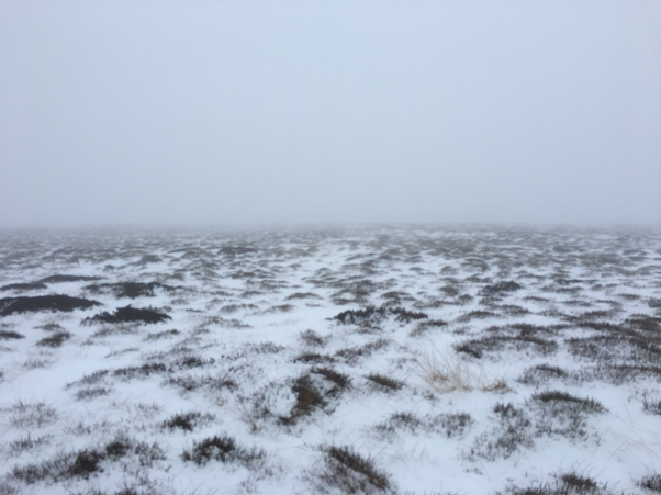
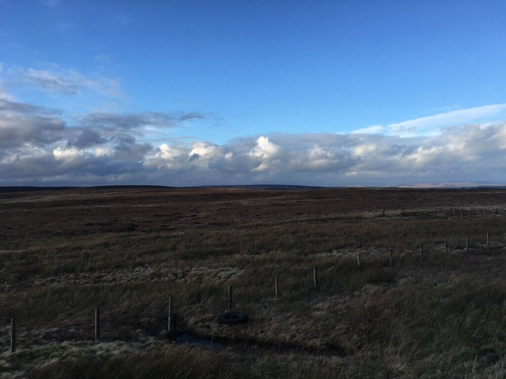
I arrive at the locked gate to find that a vehicle has driven along the smooth track. You must get up early to find virgin snow in Bannister Country. Had there been no thaw, I could have skied either side of a tyre track, but I decide to leave my skis behind a wall and continue the plod to T35 Shackleton style. My laminated OL21 (recently awarded the Sir Mark Thatcher Seal of Cartographic Excellence) doesn’t have this non-existent road of course, but it follows the CroW shading. I have zero-visibility in the dunkelflaute. The 49.9MW solar array is on strike today, in solidarity with 300MW of stationary turbines, but our £50 million battery will gallantly keep the show on the road for almost twenty minutes. I count dips and dikes until a ruin confirms my position. It is a speck on the map, and for the first time in my life I use the magnifying glass on the compass, an intimation of mortality. The apex of the curve around High Greave is clear and I plod perpendicular to the road to find T35 on Flaight Hill. Muttley obviously doesn’t know that a ‘flaight’ is ‘a turf cut for fuel’ so this site may be on much deeper peat than his probe found. Perhaps he stuck it into the imaginary road by mistake.
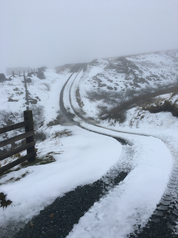
I hope the last photograph will show langlaufers the potential of this swooping skiløype. As the unfailing Ouija board at ///what3words puts it: ///midwinter.undulation.civic. Follow the yellow peat road and beware of getting your poles caught in the three-metre deep probes Muttley has driven through the impenetrable aggregate.
++++++++++++++++++++++++++++++++++++++++++++++
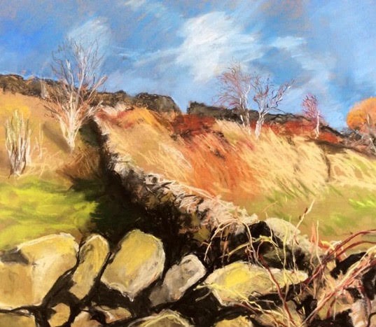
Joan Foye was born in Liverpool and studied Fine Art at Liverpool College of Art. She works in a range of media and spends much of her time on hillsides and in ditches trying to capture light and weather. She can be found on Instagram as @jfoyeart.
This is the 5th in a series of 65 guest blogs on each of the wind turbines which Richard Bannister plans to have erected on Walshaw Moor. Turbines 11, 43, 47 and 64 have already been described. To see all the blogs – click here.
[registration_form]
Thank you for your commitment to this cause. It’s inspiring to read your observations and the dubious transparency of the proposal.
As always, there’s bits in this series of guest blogs that make me smile.
“Trespassers will be prosecuted”. Nowadays the ability to do that is down to newer legislation.
Which then reminded of a sign which may exist in the US.
“Trespassers will be shot. Survivors will be shot again.”