Nick MacKinnon is a freelance teacher of Maths, English and Medieval History, and lives above Haworth, in the last inhabited house before Top Withens = Wuthering Heights. In 1992 he founded the successful Campaign to Save Radio 4 Long Wave while in plaster following a rock-climbing accident on Skye. His poem ‘The metric system’ won the 2013 Forward Prize. His topical verse and satire appears in the Spectator, and his puzzles and problems in the Sunday Times and American Mathematical Monthly. Email: nipmackinnon@gmail.com
Turbine 28 SD 98449 34067 ///overpaid.arching.common
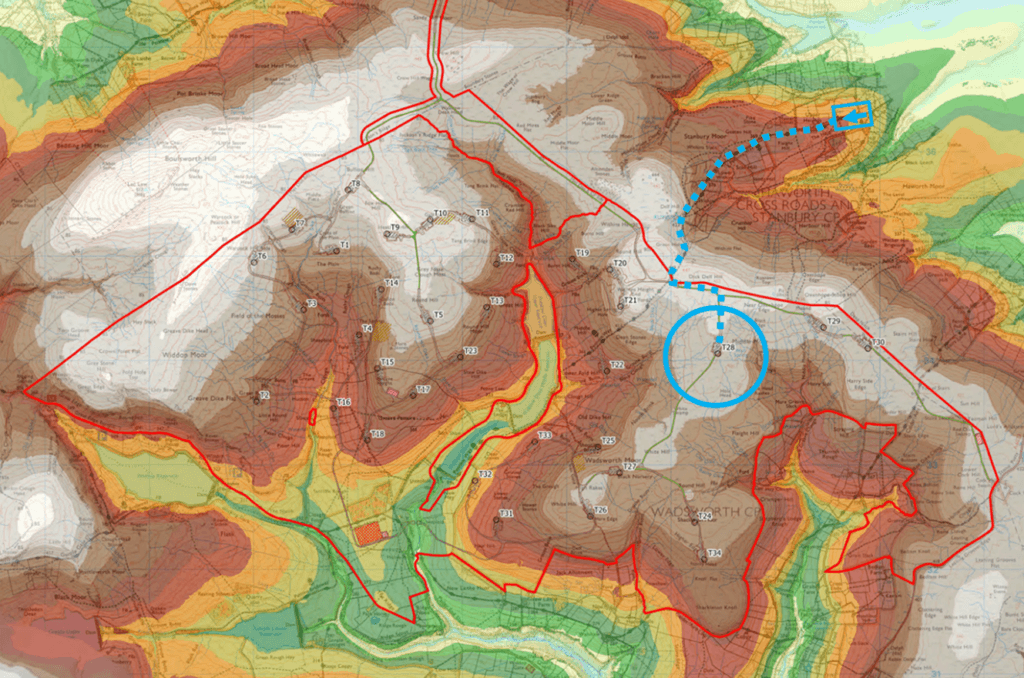
Today, a brisk walk to T28 Middle Moor with Ali West, who has been with this blog almost from the beginning. T28 is the one I noticed was 342 metres out from the maps when the PEIR came out, when it was given as SD 98627.603 33774.699. Its correct position inside the square ///overpaid.arching.common spookily prefigures the theme of this blog, which is the overarching comment of the Planning Inspectorate (PINS), given at the beginning of their Scoping Opinion, adopted by the Secretary of State (then Ed Miliband, now Miatta Fahnbulleh) on 10 October 2025. The previous blog Crow Hill Junction describes the bog burst problems on Crow Hill.
In this blog we shall show that the moral authority of the CEP proposal has been squandered on three shameless lies that attempt to cover up major deficiencies. We shall also destroy the peat landslide hazard and risk assessment. The proposal cannot survive as designed. Even if redesigned, it cannot be ready until November 2027 and Algihaz will pull the plug. Investors cannot tolerate startling incompetence on this scale and neither can the Planning Inspectorate.
Overarching comment
“The Scoping Report defines a set of ‘search areas’ as the design is at an early stage with the locations of components not yet confirmed. The Scoping Report includes details of several components/processes which may be required during construction and operation.
The Scoping Report also sets out the sensitive location of the proposed development site, located in or near a number of designated sites. The Inspectorate considers therefore that by the time of the preparation of the ES the amount of sensitive environmental receptors could change. The ES should therefore carefully set out how the design has evolved in response to environmental constraints and in response to consultation feedback from relevant consultation bodies. This should include demonstration of how a mitigation hierarchy approach has been followed in the development of the design.”
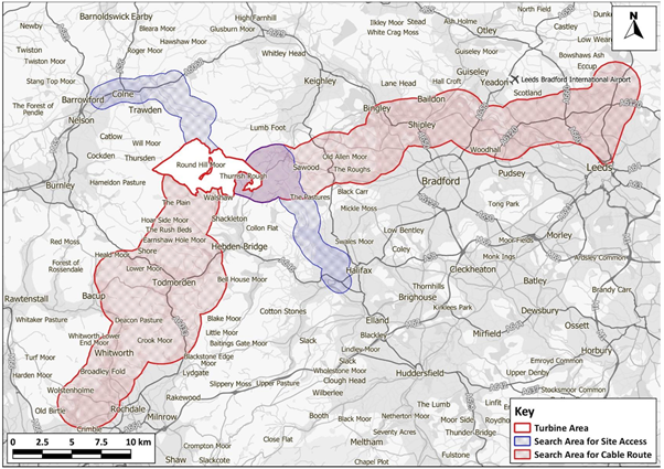
PINS are highlighting a feature of the blue access corridors. If access is taken from the east (M62/Halifax/Cock Hill) the turbine area can be reached on public roads without extra effects on the internationally designated SPA, SAC and on the Brontë Moor, which is the statutory setting of the Grade I listed Haworth Parsonage. However, if access is taken from the west (M65/Colne/Crow Hill) new tracks would have to be built through land with triple international significance, inverting the mitigation hierarchy in favour of private convenience.
Mitigation hierarchies structure every planning application
The moral authority of the planning system depends on assessment of alternatives relative to mitigation hierarchies using evidence baselines. The CEP proposal involves many levels of alternatives, like the gaps between vertebrae in the spine: cervical (C1-C7), thoracic (T1-T12) or lumbar (L1-L5).
Right at the top the National Policy Statement for Renewable Energy Infrastructure (EN-3) is assessed relative to the international designations: SPA (call it the cervical “C1-C2 gap”); SAC (“C2-C3”); and the globally renowned Brontë Moor (“C3-C4”). The proposal can break fatally at any of those places. We know there is a major “alternative sites” problem for CEP, because there weren’t any. The Algihaz lawyers, Pinsent Masons, will try to justify a generic idea of “alternatives” that is not common sense, and their wriggling is already outlined in PEIR Chapter 5 on Alternatives and Design Evolution. We have plenty to say on this, but not in this blog.
It is easier for everyone if we show the proposal is already broken in the thorax, at a decision to prefer Crow Hill to Halifax for access. The evidence base and case law weight have such unstoppable force that CWFL have already launched a cover-up.
Further down still, in the lumbar region, another example of a mitigation hierarchy determines the watercourse crossings. In PEIR Appendix 10-5, the choice between bridge, open culvert and piped culvert is made using “catchment area above the crossing”. The PEIR is clear and rational here, but the crossings are not existential like site alternatives or access. It reduces credibility to attack everything in the PEIR. The things that are suitable contrast with the things that are disastrous. Nonetheless, we shall engage later with wc14 and wc15 where “We’re gonna need a bigger pipe!”.
CWFL must provide all the evidence baselines. I think the Ornithology baseline is suitable for examination and I would not expend credibility, nor antagonise PINS, by disputing its specifics; the proposed mitigation, relative to the PEIR evidence of a wonderland, is much more vulnerable. The baseline for the Brontë Moor is non-existent and the proposal will fail at examination if this is not supplied. I happen to know what it should look like, but I am not going to do the work for Wessex Archaeology, because it is 300 hours of skilful work. As Bradford Council observed in 2023, “Innovation will be required”. The EN-3 Alternatives baseline is being constructed to retro-fit Walshaw Moor, and Pinsent Masons will be on danger money to get that through examination.
Some people underestimate the global force of the Brontë Moor. I walked the dogs early on Bank Holiday Saturday to avoid the Brontë pilgrims crush, yet at 7 a.m. I met a Japanese woman alone at ‘Wuthering Heights’ and she was in tears. “Everything here!” She had walked up from Ponden Hall (‘Thrushcross Grange’) the hard way that Cathy and Heathcliff ran as children, past ‘Penistone Crag’ and across the course of the 1824 bog burst that almost killed Emily (6), Anne (4) and poor Branwell (7) the above-average boy in a family of heart-breaking genius. “Everything here!”
The fatal break
The choice of access to the site is not so obviously fatal as the cervical mitigation hierarchies; perhaps it is thoracic (T1-T2). In the PEIR, CWFL opted for the western access by Colne/Crow Hill, for all the turbine components and 616,000 tonnes of non-calcareous aggregates. The turbine area infrastructure is designed in detail relative to that choice. We shall show the PEIR design is unlawful because they should have chosen Halifax/Cock Hill, for three legally compelling reasons.
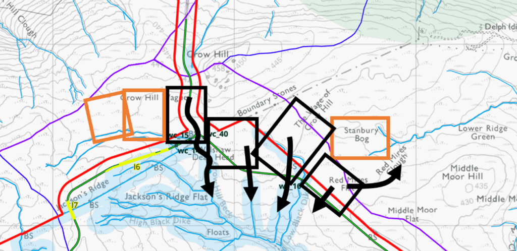
Crow Hill access inevitably takes more of the internationally significant SAC, SPA and Brontë Moor than the eastern route through Halifax; the choice inverts the Ecology and Heritage mitigation hierarchies, and the PINS overarching comment asks for clear explanations. The map below illustrates the access routes from the motorways and indications of three hierarchies: safety, ecology, Brontë Moor. EN-3 cannot muddle the choice of Crow Hill because there is a clear alternative via Halifax. There is a convoy of law from the highest courts on this point, laid out later.
Readers may wonder why the same convoy does not also apply to the “cervical choices” too. It does apply, so the Algihaz lawyers, Pinsent Masons, must complicate the idea of “alternatives”, and persuade PINS that the legalistic fuzz they whip up is justified by EN-3. If they can’t convince PINS on that, the proposal dies. This is the roulette table on which Algihaz have placed their venture capital bet. Because it has taken so long to get to the spin, Algihaz have already spent a lot of money. Even if the proposal goes perfectly from now, Algihaz have paid £30 million for a chance to own a site they can flip for £35 million, but at huge cost to their reputation for competence. This blog will show that they have no chance, must redesign, and try for November 2027. With credibility lost, they will have spent £45 million for a tiny chance (given total loss of credibility and moral authority) to flip the site for £35 million. Algihaz are now chasing their mounting losses. Had they got their original 312 MW proposal through they would have spent £15 million on a site worth £46 million
If consented, CEP will have irreversible effects on the SPA, SAC, and Brontë Moor. The EN-3 conception of what “alternatives” means may somehow allow this. The destruction is unavoidable if a wind farm is consented. However, the destruction can always be reduced by designing the proposal via Halifax rather than Crow Hill, yet CWFL have chosen Crow Hill.
Algihaz may now realise that the proposal is already broken in the thorax on Crow Hill. Their Cavendish henchmen know; they have published three shameless lies to cover-up the break. CEO Mustapha Hajjar knows. I have sent him this analysis.
The map below shows the relationship of Options A and B relative to safety (bog burst), ecology (SAC/SPA), and heritage (Brontë Moor) mitigation hierarchies.
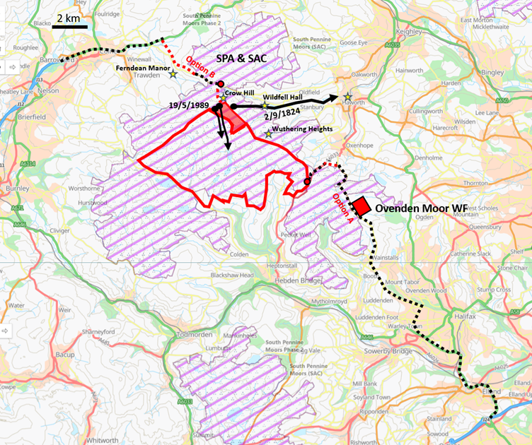
Option B quantitatively destroys more of the international SPA/SAC/Brontë Moor and there is nothing of that calibre on Option A to balance it.
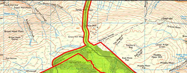
Qualitatively, the pink shaded Crow Hill, which was added at PEIR to the site, is the most sensitive for Brontë heritage; it also has the deepest peat (SAC) and the least human intrusion (SPA) so again Option B is much worse than Option A. Turbines have already been delivered by Option A to Ovenden Moor WF. Option B passes through the only repeated bog-burst zone in Great Britain.
No explanation for this inversion of the safety, ecology and heritage mitigation hierarchies is given in the PEIR Hydrology, Biodiversity or Historic Environment chapters. No overall explanation is given in the Project Design and Evolution chapter either; it should be in the vicinity of 5.7.39.
Instead, three explanations are given in the FAQs that are shameless lies. Christian Egal is responsible for them, but he has plausible deniability. He didn’t have time to read the incompetent Logika Scoping Report, so he can hardly be expected to read the FAQs. They are written by Cavendish Consulting for ordinary readers, who, it must never be forgotten, are paying for all this in their electricity bills. Until I hear otherwise, Cavendish were directly responsible for writing and publishing these shameless FAQs.

“Following further technical and environmental assessments, the western route is now the proposed (Abnormal Indivisible Load) AIL route, as it avoids or minimises impacts on key environmental and heritage features.” This is obviously untrue. The western route maximises the environmental and heritage impacts at the pinnacle (SAC, SPA, Grade I listed) of the hierarchies.

The western access route cannot be the “safest” of two options, A or B, nor is it the “safer”. It requires heavy haulage tracks to be built over the only repeated bog-burst zone in Great Britain, and the hazard was known but unassessed when CWFL published the “safest” FAQ.
The moral authority of the proposal evaporates with these three shameless lies, thought good enough to bamboozle the bill-paying public, but not to show PINS in the PEIR. As usual, once exposed, the cover-up highlights the problems. Somebody at CWFL already came this way, saw some of the trouble, and wrote those FAQs. Lies always point to the truth. CWFL could not state the only reason for the choice of Crow Hill which was “private convenience”.
Whoever wrote “safest” cannot have known how much trouble the peat landslide assessment is in on Crow Hill.
The PPLHRA
The crucial baseline for the safety assessment of the western access is the Preliminary Peat Landslide Hazard and Risk Assessment (PPLHRA). The author “AJM” is Dr Andrew J Mills, and consultancy OWC own the liability. I met Dr Mills at Hebden Bridge on 21 April 2026, where I had just served Christian Egal with a formal notification that T28 was 342 metres out of position. I worked that out using the last map in the PPLHRA, since revised, because it was luckily both the most legible and the only one that had the wrong positions. The CWFL engineer Donald Mackay said, “Great spot on the turbine locations, by the way!”
In the PPLHRA, Dr Mills first disclaims the possibility of assessing the Crow Hill bog bursts with the information he has been given.
“The spatial scope of this PPLHRA at PEIR is limited to the Turbine Area within which turbines are proposed and does not extend to covering the Access Routes nor the Bradford West Cable Corridor, as shown in Plate 1.1. These components of the Proposed Development will be assessed once supporting peat depth data is available.”
This already means that CWFL had no basis for their shameless lie that the western route is “safest” because they had no expert assessment of the bog-burst hazards on Crow Hill.
“A bog burst was documented on Crow Hill near Haworth by Brontë in 1824, and this is likely the nearest recorded failure to the Turbine Area (Ross, 2021).”
Dr Mills will get his bog bursts in a twist because he thinks there is only one event. The reference to “Ross, 2021” is slapdash. Dr Mills means “Ross, 2020”. Had he read Ross, 2020, he would know that there are eight recorded bog bursts on Crow Hill, in three separate events between 1824 and 1989. The 1824 events are not “the nearest recorded failure to the Turbine Area.” We shall later meet that in Dr Mills’ PhD thesis…
“The term “bog burst” is used to refer to very large-scale (usually greater than 10,000 of cubic metres) spreading failures in which the landslide retrogresses (cuts) upslope from the point of failure while flowing downslope. Where such events occur, the peat is typically deeper (greater than 1.0m and up to 10m) and more amorphous than sites experiencing peat slides, with shallower slope angles (typically 2°-5°). Much of the peat displaced during the event may remain within the initial failure zone. Bog bursts are rarely (if ever) reported in the UK, other than in the Western Isles of Scotland (e.g. Bowes, 1960), and notably, immediately to the north of the Turbine Area.”
Dr Mills tells us that though UK bog bursts are rare, they are “notably” clustered on Crow Hill where he says there have been two. “UK” is slapdash because it includes Northern Ireland, where bog bursts are more common. It is clear that Dr Mills means “Scotland, England and Wales” for which “Great Britain” is the correct term. The official bog-burst distribution in GB is Scotland 5, Wales 0, Crow Hill 3.
“There are no published failures or news reports of landslides in proximity to the Proposed Development. Review of the nearby wind farms in similar settings (Hyndburn Wind Farm, Coal Clough Wind Farm, Todmorden Wind Farm, Reaps Moss Wind Farm, Crook Hill Wind Farm and Scout Moor Wind Farm show no evidence of failures in association with construction.”
Dr Mills means by “in proximity” that the South Pennines, except Crow Hill, does not host peat landslides and that the nearby wind farms have not caused any. We see how Dr Mills is failing to understand Bayesian prior probability. The absence of bog bursts at the other wind farms strengthens the case that Crow Hill is very unusual, since it has hosted several. If you build a wind farm anywhere in the South Pennines except Crow Hill, you don’t have a bog burst history.
“To the north of the Proposed Development, there are two recorded peat landslides (eastern and western), one, or both of which are known together as the Crow Hill bog burst (Ross, 2020), described by the Rev. Patrick Brontë. The eastern landslide is connected to Ponden Clough Beck (also Ponden Clough / Cleuch), with impacts on this watercourse being described in Brontë’s account of the event. The western landslide is located closer to Crow Hill, but is connected to Crow Hill Beck. Both were reported by Brontë as occurring during the same meteorological event. Accounts of effects on watercourses documented in Ross (2020) include effects in Leeds and even effects on water colour as far east as the Humber Estuary. These distances are far in excess of impacts documented for peat slides, though some bog bursts documented in Ireland have reported far-reaching impacts extending to tens of kilometres.”
A key error, and it is very serious, is Dr Mills’s claim that Brontë reported both the western and eastern landslides as occurring in the same event. This is false. The bog burst documented by Brontë is only the eastern one between The Wage of Crow Hill and Stanbury Bog. Brontë’s account is set out in Ross, 2020 pp. 38-41. The italics are mine.
“During the time of a tremendous storm of thunder, lightning and rain, a part of the moors in my chapelry … sunk into two wide cavities; the larger of which measured three hundred yards in length, about two hundred in breadth, and was five or six yards deep. From these cavities ran deep rivers, which uniting at a distance of a hundred yards, formed a volume of mud and water, varying from thirty to sixty yards in breadth, and from five to six in depth; uprooting trees, damaging or altogether overthrowing solid stone bridges, stopping mills, and occasionally overwhelming fields of corn, all along its course of ten or fifteen miles.”
The event was in Patrick Brontë’s Stanbury chapelry (an extension of his Haworth parish) on the Yorkshire side of the watershed. There were two cavities, both on Stanbury Bog, with peat outflows “uniting”, accelerating down Ponden Clough and draining to the Worth and Aire. Bog bursts are huge, and there were two on Stanbury Bog, on Tuesday 2 September at 6 p.m. and Wednesday 3 September 1824 at 8 a.m. There were four more separate eruptions on Thursday. The LIDAR map below shows multiple explosions.
The maps show three events on Crow Hill Wague and The Wage of Crow Hill that Dr Mills has compressed into a single meteorological event in 1824.
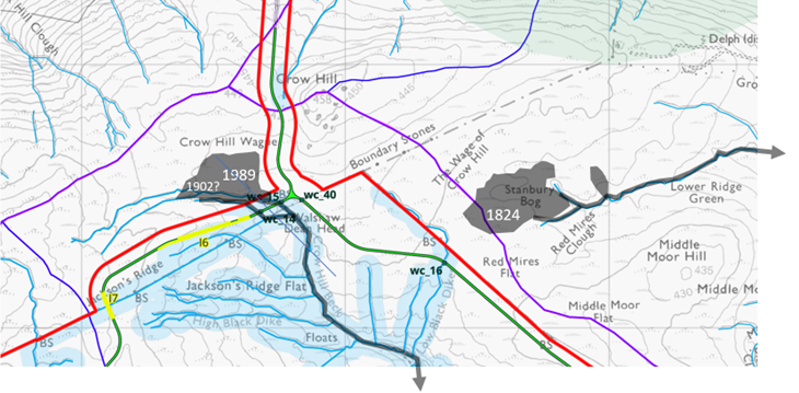
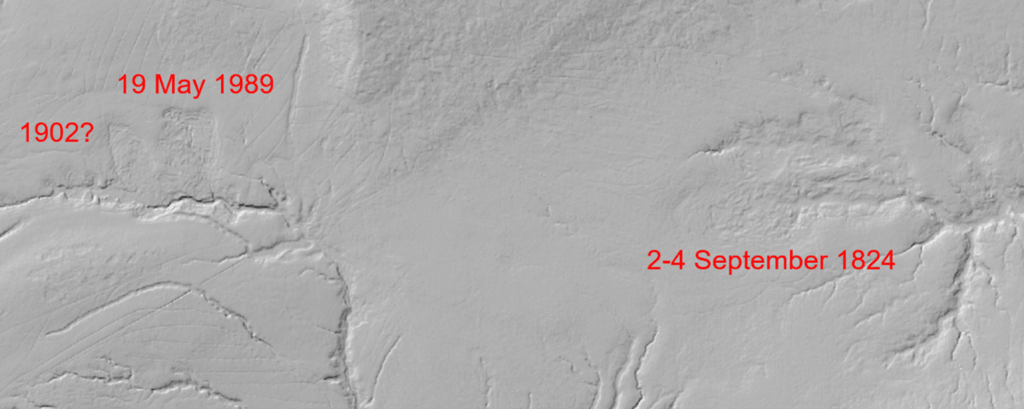
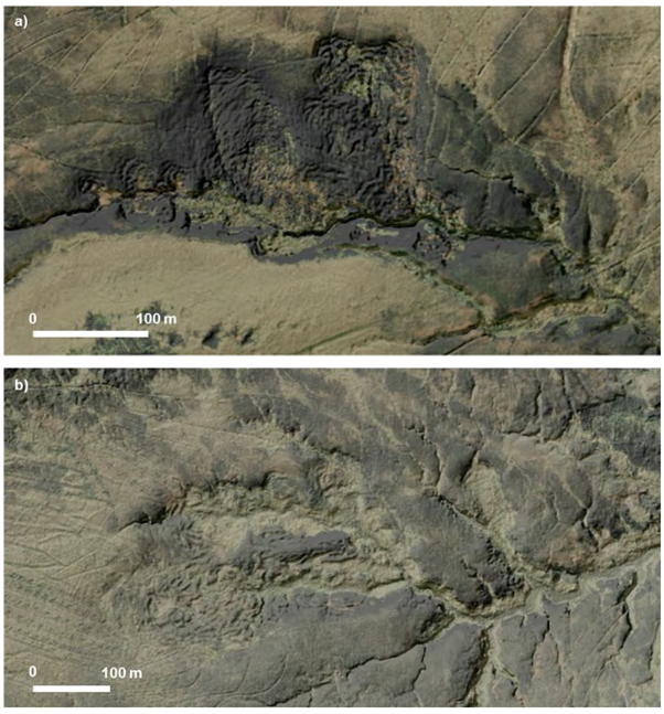
Dr Mills’ “western bog burst” was mainly in Lancashire, but drained to the Yorkshire Calder down Walshaw Dean, because the watershed on the flatness of Wague and Wage is not quite where the boundary stones go. There are in fact two Lancashire bog bursts here; we have no date for the smaller one. Preliminary weather-pattern analysis suggests it could have been 1902, following a long Yorkshire drought. The Walshaw Dean reservoirs were begun in 1900. If Dr Mills wants to do the work, he may find evidence for a 1902 bog burst in Enoch Tempest’s reports to the Halifax Waterworks Committee.
“We’re gonna need a bigger pipe”
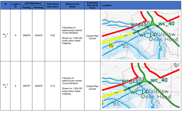
Dr Mills got the wrong end of the stick from Patrick Bronte’s description of the two cavities on The Wage of Crow Hill, both draining to Stanbury; he read this as describing what he calls the western and eastern bog bursts, but their outflows could not “unite” because the western outflow goes down Crow Hill Beck into Walshaw Dean. If CEP is built on Crow Hill, the next Wague bog burst will find its path blocked by wc14 and wc15 over Crow Hill Beck which PEIR Appendix 10-5 says will be “closed pipe culverts”. Note how tiny the assumed catchment areas are. A bog burst might be 100,000 m3 per minute. “We’re gonna need a bigger pipe.” Of course, if the culvert pipes were properly designed to cope with the likely bog burst, that would prove the point about the bog burst.
The western bog bursts are unconnected to the Brontë one
In his letter to the Leeds Intelligencer, Brontë reports that a “great crater” appeared surrounded by many smaller pits. At eight o’clock the next morning, a further eruption occurred.
In 1879 J. Horsfall Turner reported his record of four further separate eruptions on Thursday 4 September 1824, sending peat over the steep of Ponden Clough. On 16 September, Brontë reports that the larger cavity had extended itself, ultimately reaching over a mile in circumference as a result of multiple eruptions and of the mass “sinking, principally by its own weight.”
There is thus no evidence in Ross, 2020 that the “western bog burst” had anything to do with the famous eastern bog burst, that almost killed Branwell, Emily, and Anne, and eventually left one huge crater, that Ross says thousands of tourists came to see: it was the beginning of Brontë Country.
In fact the evidence of Ross, 2020, shows that Dr Mills’ “western bog burst” cannot be in the same meteorological event as the Tuesday-Thursday 2-4 September 1824 events, or Brontë, and thousands of others who went to see, would have reported a third crater on the Calderdale side of the watershed draining to Walshaw Dean. All Dr Mills needed to do was plot his beautiful LIDAR images on the CWFL hydrology map and the point would have been clear. Alternatively, he could actually read Ross, 2020, Charlotte Brontë at the Anthropocene by Shawna Ross, which is the master account of the three (or eight, if Stanbury Bog is counted as the six reported) bog bursts on Crow Hill.
This understanding of three independent bog bursts is crucial. If we accepted the PPLHRA false statement of one bog burst in 200 years, then the probability of one or more in the next 50 years would be 22%, still too high for safety, given the consequences. In fact there have been three bog bursts, so the probability is 53% of one or more bog bursts in the next 50 years, before we allow for the known pre-conditioning factors and the triggering factors of heavy haulage infrastructure.
“Outside the Turbine Area to the north, the Crow Hill bog burst (a much reported peat landslide, documented by Rev. Patrick Brontë (Ross, 2020) is located to the west of the Western Access Route. The landslide took place in 1824 (c. 200 years ago), and remains visible in the landscape. It occurs within gently sloping peatland drained by Crow Hill Beck and is likely to have been triggered by sidewall collapse of the watercourse, possibly during a spate event.”
This is dangerously wrong, as we have seen. Any bog burst west of the Western Access Route could not threaten Emily and Anne at Ponden. Dr Mills may fear his readers cannot subtract 1824 from 2026, but the reason he says “c. 200 years ago” is to suggest that all this was a single event a long time ago. Most of what Dr Mills is looking at in the west is in fact the 1989 bog burst that the PPLHRA misses.
“A similar feature is located in Stanbury Bog to the southeast of Crow Hill. Its morphology (form) is less clear than that of the Crow Hill burst and it may be of a similar age (i.e. not recent).”
Wrong. We know exactly when this one happened. It started at 6 p.m. on Tuesday 2 September 1824; and the bog exploded again on Wednesday 8 a.m. and four times on Thursday, a total of six bog bursts. The reason the eastern bog burst “morphology is less clear” than the western one is that most of the western fingerprint was made in 1989.
“Stability of the westernmost bog burst has yet to be assessed in detail, but will be post-PEIR. Both bog bursts are outliers in the reported population of landslides in England, which are largely focused in the North Pennines, with few if any other landslides reported in the South Pennines.”
Dr Mills seems to introduce a third bog burst (“westernmost”) but he only knows of two. He states that it is yet to be assessed in detail, indicating that the FAQ claim that the western route was chosen because it was “safest” was a shameless lie, though not of Dr Mills’ telling.
PPLHRA misses the 1989 bog burst
As we already see, Dr Mills has mastered neither Ross, 2020 nor “Ross, 2021” nor his own LIDAR maps. The biggest problem for his paymaster Algihaz is that Ross gives a third bog burst, in 1989, and Dr Mills misses it, though it is described by Ross on pp. 67-68, and she gives a full reference to a photograph and description in Dykes & Warburton, 2007. D&W has only 21 pages, Dr Mills relies on it seven times in the PPLHRA, but he still didn’t see the photograph of the 1989 Crow Hill bog burst on page 82. Dr Mills’ inability to spot the 1989 bog burst will reach a comic level further down the blog, by which point the PPLHRA will be a dead parrot.
When I asked Dr Mills about the 1989 bog burst, he went out to his car and came back with a copy of Ross, 2020. I invited him to find the 1989 bog burst. He still could not. I showed him it on pages 67-68, where Ross also gives a reference to the paper by Dykes & Warburton, which has a photograph of the 1989 event on Crow Hill. It was at this point that Dr Mills told me that Professor Warburton had been his doctoral supervisor. He complained that Ross, 2020 was a work of literary criticism, but of course it was Dr Mills’ reference, and he had not read it. I now know that Dr Mills’ obvious bewilderment at Hebden Bridge was caused by his being the founder (in 2002) of a World Database of Peat Landslides that didn’t have the 1989 Crow Hill bog burst in it, because … Not long to wait!
Dr Mills should also have read the analysis of the 1989 bog burst that Haworth-with-Stanbury submitted in response to the Scoping Report. I wrote it, and gave a plausible date of 19 May 1989, the same day as the ‘Halifax storm’. The rain at Walshaw Lodge was the highest ever recorded in a two-hour interval. As in 1824, the storm followed a drought, which is the weather pattern that causes the sudden change of state in the basal peat.
By missing the 1989 bog burst, and suggesting wrongly that the western and eastern bog bursts were in same meteorological event, the PPLHRA is dangerously misleading, because it compresses three separate events, composed of eight bog bursts between 2 September 1824 and 19 May 1989, into a single event in 1824.
Frequentist and Bayesian Prediction
There are two fundamental approaches to statistical prediction: frequentist and Bayesian. Both are philosophically sound, but frequentists must not play poker with Bayesians because they’ll be taken to the cleaners. If you a drew a tree diagram at school, you were working in a Bayesian framework, now made more explicit even at GCSE.
A random km2 of peat in England has hosted three separate bog bursts in 200 years. This a frequency of 0.015 bog bursts per year. The probability of no bog burst in a year is 0.985, and the probability of no bursts in the next fifty years is 0.98550 = 0.47 or 47%. So the probability of one or more bog bursts is 53%. This is the frequentist estimate, and it is already very significant for Crow Hill, but it must be an underestimate, because the special, even unique, preconditioning and triggering factors are left out of the analysis.
The insight of Thomas Bayes (1702-1761) is that there are unaccounted factors in the frequentist approach. Any PLHRA has to build in this “Bayesian prior probability” somehow, because wind farms are never constructed over sites where there have already been bog bursts, so they are always “zero bog burst history” by definition. To predict bog bursts on consent-able wind farm sites with no history, you have to look at the factors, which is what a PLHRA does.
The Bayesian prior probability is embodied in 10 “pre-conditioning factors” and five “triggering factors”. Enough red flags would suggest a high risk of bog burst even without history. Crow Hill has a very significant set of pre-conditioning and triggering red flags. They can be summarised in two tables.
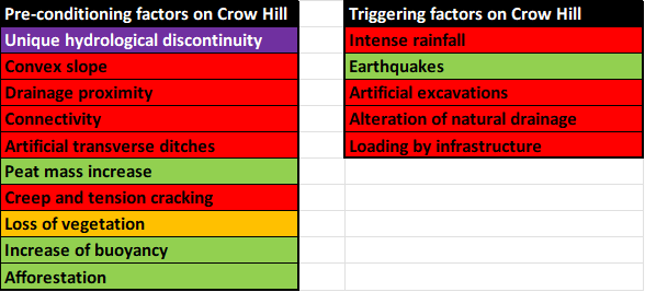
The extent and flatness of Crow Hill Wage and The Wage of Crow Hill mean that the type of peat landslide would be a bog burst rather than a peat slide. The purple and red flags in the factor tables mean that the frequentist probability of 53% based only on the history, must be a considerable underestimate.
“That’s bad!”
At Hebden Bridge, I gave Dr Mills an explanation for this unique cluster of three (or eight) bog bursts: the unique hydrological discontinuity of the impermeable Keighley Blue that forms Crow Hill. Dr Mills got this at once: “That’s bad! What is the strike of the formation?” I can’t be expected to do everything for Dr Mills, but the beds slope very gently towards the Wague and Wage. I take Dr Mills’ reaction to indicate that he is still a fascinated peat scientist, not an Algihaz minion.
Since we have a unique pre-conditioning factor for hydrological discontinuity, Crow Hill is a text-book bog burst generator. Once the triggering factors, especially the three heavy haulage aggregate tracks converging at Crow Hill Junction, are integrated into the prediction, the probability of a bog burst is much higher than the frequentist 53%.
Dr Mills is a serious academic and lovely man who finds himself serving shameless liars. He will survive this setback to write a fascinating academic account of the Crow Hill cluster, and will doubtless credit me for the “Keighley Blue hypothesis”. As an opponent of CEP, I am thrilled with the utter horlicks Christian Egal has presided over on Crow Hill, but Algihaz cannot have this fiasco unpacked at examination. It strikes at the heart of their reputation and the moral authority of their proposal.
It gets worse.
PPLHRA uses the Scottish guidance which Dr Mills helped to write
The standard for Peat Landslide Hazard and Risk Assessment is published by the Scottish Government and is explicitly the basis of the CWFL PPLHRA. There may one day be an English standard, but it will be written by the same experts. It states:
5.6 Mitigation The extent of mitigation required will depend upon the scale of the project, the nature of the risk and estimated risk level. A combination of options may be required to reduce the risks to an acceptable level for a given scheme.
5.6.1 Avoidance Areas exhibiting medium or high risk levels associated with peat landslides should be avoided, for example by relocating infrastructure within the development area or by relocating to an alternate site. Where avoidance is not possible, the proposed design should be modified to incorporate engineering measures to reduce or eliminate the assessed risk.
Algihaz will be shattered to learn that the advisors to the Scottish Government Peat Landslide Guidance on which the PPLHRA depends, were Professor Jeff Warburton, who published their 1989 bog burst, and Dr Andrew Mills who missed it in their PPLHRA.

Although there are engineering mitigations to peat slides, including pinning the peat to the stable substrate and erecting catch fences to intercept the debris, neither can be used against the liquid slurry of a bog burst. On Crow Hill, with its three independent bog bursts, avoidance is the primary mitigation, and the Halifax option completely avoids Crow Hill.
Andrew J. Mills PhD
We are almost done with Dr Mills, who has suffered enough, but there is one more delicious thing for Algihaz to swallow. Back to the PPLHRA:
“Evans and Warburton (2007) present useful contextual data in a series of charts for two types of large-scale peat instability – peat slides and bog bursts. The data are based on a peat landslide database compiled by Mills (2002) which collates site information for reported peat failures in the UK and Ireland.”
I was chasing the reference “Mills 2002” when I discovered that the author AJM of the PPLHRA was Dr Andrew J. Mills, and he was referencing his own work. Mills 2002 is the basis of his 2003 PhD thesis. I hoped to find his database of all bog bursts so I could estimate the Bayesian prior probability of bog burst on Crow Hill. Dr Mills and I could then write a joint paper if he will pony up his full database rather than the thesis summaries. I know for a fact that he has not mastered the Bayesian approach, or he wouldn’t attempt a PPLHRA for bog burst on Crow Hill the way he has begun. His coloured maps are worthless for bog bursts on Crow Hill. We might rope in Warburton, Evans, and the nominatively-determined Dykes, who with Mills are the Federer, Nadal, Djokovic and Murray of peat landslides. There are young guns who threaten the supremacy of this “big four”. Flavia Ferriero, Fausto Guzzetti, and Warner Marzocchi published Bayesian forecasting of triggered landslides on 2 April 2026. Thomas Bayes would have been astonished by his posthumous fame: the tragic superyacht Bayesian was named for his work.
What I did find in Dr Mills’ PhD thesis is a photograph, taken by Evans. There are two Evanses in the PEIR: this one is Robert. Below is the PhD page, cropped to the Evans photograph c). Spot the mistake in the caption! This error is the source of all of Dr Mills’s problems on Crow Hill.
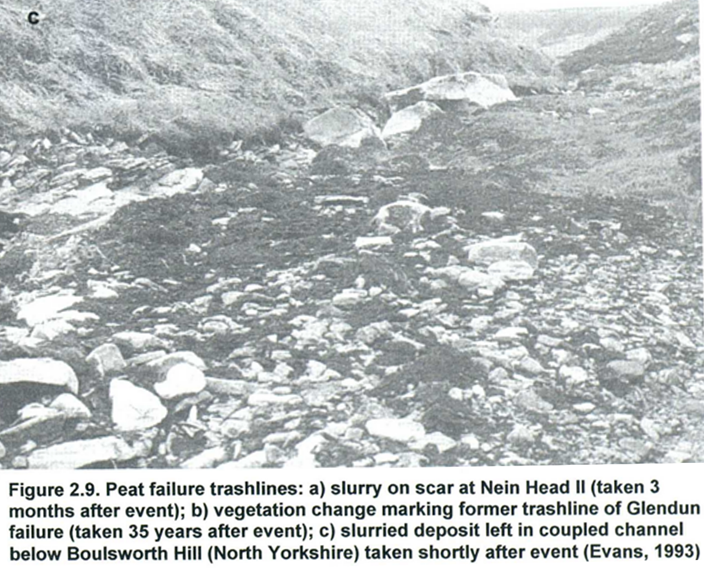
I have been at this a long time, as some readers know, and none better than Mark Avery. I first read that caption on 30 August 2026, two years and nine months after starting at Mere Stones and it was the moment that I knew the PEIR design was dead. There is only one Boulsworth Hill and it is not in North Yorkshire. The Evans photo looks very like Boft Hole at the top of Walshaw Dean. Surely, the not-yet Dr Mills had published in his thesis a photograph of the trashline of the 1989 Crow Hill bog burst that he then failed to discover in his PPLHRA for Calderdale Energy Park over twenty years later. He thought the 1989 event was in North Yorkshire!
Dr Mills miscaptioned his PhD thesis photo
The last leg of the chase was to Evans 1993. It is a paper in Landscape Sensitivity, and eBay had the book for £24. It was stolen from the University of Glamorgan, and I shall send it back after the PINS examination. Published in 1993, it had been taken out in June 1994; then March, May, June 2001 (surely the same reader); April 2002; and then by the blessed thief on 10 January 2003, just as Dr Mills was pasting the photo of “Boulsworth Hill, North Yorkshire” into his PhD. The thief cannot be Dr Mills: had he had the book, he would not have miscaptioned the 1989 photograph.
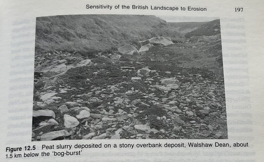
It is Walshaw Dean. Since this is the evidence that destroys the credibility of the PPLHRA, here are the other two photos that Evans took of 1989 bog burst residue on Crow Hill Wague, that is right next to CEP’s access track.
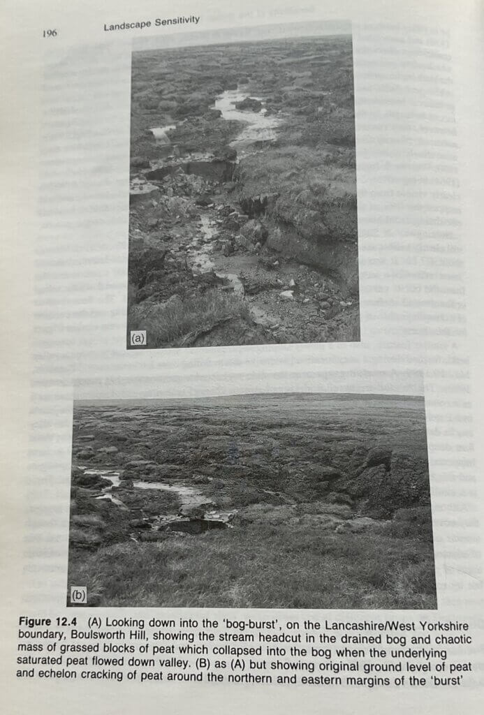
Evans says this of the 1989 bog burst.
“A similar feature, also in a gently sloping depression (1° steepening to 4°) within a valley head, formed during a very localised intensive storm falling over 2 hours in the central Pennines, 19 May 1989. A rainfall gauge near the slide registered a questionable 193 mm (Acreman, 1989). The rainfall triggered widespread stream channel widening and deepening, as well as a rotational slide in head (Acreman, 1989; Evans, unpublished). The stream now heads in a 1 m high ‘knick point’ in indurated head, a few metres upslope of where the downvalley cracks delineating the margins of the burst meet the stream (Figure 12.4). The peat was about 4 m deep, and the burst was about 300 m long and 250 m wide. What appeared to have happened was that peat ‘slurry’ (Fig. 12.5) flowed out from the base, so undercutting it, and this was followed by collapse of the peat into a chaotic jumble of arcuate slips. There is a similar, though vegetated, feature close by.”
Evans, “Sensitivity of the British Landscape to Erosion”, Landscape Sensitivity, ed. D.S.G. Thomas, R.J. Allison, Wiley 1993 (pp. 195-197). The Acreman reference, which Dr Mills will be wanting, since he doesn’t have the book, is Acreman, M.C. (1989) The rainfall and flooding on 19 May 1989 in Calderdale, West Yorkshire, Institute of Hydrology, Wallingford. I drew the same conclusion about the exact date as Evans in the Stronger Together response to the Scoping Report. Had someone at CWFL read that, they would not now be in such trouble, but as they didn’t even read their own Scoping Report, they were hardly likely to read what Haworth-with-Stanbury thought about it.
The 1989 bog burst on Crow Hill Wague was a 300,000 m3 event, which is by a nice coincidence almost the same as the 280,000 m3 of aggregates that must be imported to build all of the CEP tracks, compounds and hard standings.
Dr Mills must recommend avoidance of Crow Hill
The next bog burst on Crow Hill will be down the line of the access track. I am certain that once he had assessed Crow Hill in detail, Dr Mills would have told CWFL to avoid the area, which is the primary mitigation of the Scottish Government advice that Dr Mills himself helped to write. In fact, much of the Scottish Government advice is taken directly from the Mills PhD thesis, which has been very influential. The tenses in this paragraph are chosen to indicate that I am not expecting to read Dr Mills’ final PLHRA on Crow Hill, because Algihaz either pull the DCO application or they pull Dr Mills.
If Algihaz want to keep going, it would be a mistake to pull Andy Mills, who is the only world authority working for CWFL, but he will have to report in the DCO that Crow Hill is a bog-burst cluster and he recommends avoidance, via Halifax. After all, there is a photograph of a bog-burst trashline in his own PhD thesis that poured 300,000 m3 through Crow Hill Junction and would have filled 120 Olympic swimming pools, in minutes.
Future hazards
The obvious hazard on Crow Hill, if CEP is built to Donald Mackay’s PEIR design, is a parallel bog burst to 1989 along the line of the N-S track over Crow Hill Wague. This is fully pre-conditioned and would be triggered by the weight of the aggregate plus the weight of a delivery. This hazard remains beyond the lifetime of CEP because the track will not be removed. It will need less of a drought and less of a storm with 2000 tonnes of floating aggregate and a 100 tonne nacelle delivery braking on the downslope. After the 1902(?) and 1989 bog bursts it is next to go.
Also highly vulnerable would be The Wage of Crow Hill, where the aggregate track we call the Stanbury Bog Expressway will alter the Wage drainage. The purple catchment lines do not indicate the complex drainage in the Wage, where the depth of peat is as great as the contour interval. Increased hydrostatic pressure NE of the Stanbury Bog Expressway could trigger an east-flowing bog burst in the Wage like the 1824 event as well as the more obvious flows SW into Walshaw Dean.
North of Crow Hill
Our final observations on the PPLHRA concern the risk of peat slide on the steep upward slope from Watersheddles reservoir to the Crow Hill watershed. The Crow Hill Keighley Blue geology is likely to have an effect here too, particularly as the track, which will be cut to the bed rock and filled with granite, as it is much too steep for a floating track, will act as a vertical conduit down to the shear plane. Again no peat depths have been found except by WTRG. I found 240 cm at Sandy Hill Moor, and that is a lot on such a steep slope. Dr Mills should therefore not have shaded the PPLHRA peat slide likelihood map as he has. I calculate that it should be red over Sandy Hill Moor.
The peat slide hazard on the steep upward slope may respond to expensive and ecologically damaging engineering mitigations. Catch fences could protect Watersheddles Reservoir and the peat either side of the track might be pinned to the substrate. The width of the zone of increased risk caused by the track north of Crow Hill is impossible to assess without full peat depths and a clearer idea of how Crow Hill’s unique geology drives the hydrology on the north side. The CEP track could unzip the whole slope.
The PPLHRA has a similar map indicating bog-burst likelihood. The methodology takes no account of the very unusual cluster of bog bursts on Crow Hill and is worthless as a guide to action. This kind of map is only valid in an area with no pre-history of bog burst.
Conclusion
We have completely discredited the PPLHRA and it must be withdrawn. CEP cannot come over Crow Hill. The whole proposal must be redesigned via Halifax.
Dr Mills is a brilliant and lovely man who has fallen foul of the curse of Emily Brontë, like so many of his fellow consultants. Ashley ‘Asbestos’ Robinson won’t make so many mistakes during the rest of his career as he let through in the CEP Scoping Report.
Tenderly, in his dedication to his doctoral thesis Dr Mills thanks his partner, who is “Kathy to my Heathcliffe”. Emily called them “Cathy” and “Heathcliff”, but that does not affect the sincerity of the sentiment, familiar to many of us under the spell of Pennine blanket bog. Dr Mills shows us again the unique power of the Brontë Moor ‘flashing afresh to hold and horrify’.
Legal and Commercial
The proposal described in the PEIR is unbuildable and cannot be rationally considered as a DCO application. It will fail at the gate, or, worse for Algihaz, at examination, and the problem has been clearly flagged by PINS well in advance. There is similar advice, more strongly phrased, logged by PINS on 26 July 2026. The proposal has been designed in ignorance of the bog-burst hazard, and the assessment has very serious and misleading errors of fact and analysis.
If PINS recommended the proposal, they would face immediate judicial review on this tight and deeply evidenced point about Halifax v Crow Hill, with its convoy of case law, and PINS would certainly lose. A “Crow Hill precedent” would invert the very steepest safety, ecology, and heritage hierarchies, despite an available alternative already proposed by the developers, in favour of private convenience. This would undermine the moral authority of every planning decision in the UK. Because the point is tight, deeply evidenced, and the case law is not affected by EN-3, it would be inexpensive to litigate at judicial review. There will also be a “Gunning principles” claim on the same points, and it is stone-cold because the public were fed shameless lies, in FAQs that are meant to aid “intelligent consideration” of the proposal.
If the Planning Inspectorate recommended rejection, and Miatta Fahnbulleh gave consent anyway, then PINS would have to take her to judicial review, because her “Crow Hill precedent” would undermine the rational basis of the planning system which it is their duty to uphold. Here is that convoy of case law.
- Waddenzee (ECJ C 127/02)
This is the foundational case for the Habitats Regulations.
The authority must exclude adverse effects on site integrity before authorising a project. Alternatives must be considered first, and only if no alternative exists can the authority move to IROPI (imperative reasons of overriding public interest).
- Sweetman (ECJ C 258/11)
This case clarifies what counts as an adverse effect and reinforces the strictness of the test.
If a project risks lasting harm to the ecological characteristics of a site, it cannot be approved unless the authority has ruled out alternatives.
- Holohan (ECJ C 461/17)
This case is crucial for alternatives.
The authority must consider all feasible alternatives, including those that are less convenient, more expensive, or not preferred by the developer.
- Champion v North Norfolk DC [2015] UKSC 52
UK Supreme Court case applying the Habitats Regulations.
Authorities must properly assess alternatives before concluding that a damaging option is acceptable.
- R (Morge) v Hampshire CC [2011] UKSC 2
UK Supreme Court case applying the Habitats Regulations.
Authorities must apply the Habitats Regulations directly and cannot rely on developer preference or convenience.
- R (Friends of the Earth) v SSBEIS [2020] EWCA Civ 214
Court of Appeal case on Heathrow expansion.
Alternatives must be considered realistically, not dismissed for cost or inconvenience.
These judgments would also be invoked at the EN-3 level should the proposal reach examination. The law is less clear at that cervical level (and therefore expensive to litigate at judicial review) because of the complication of the EN-3 guidance, which may modify the absolute force of the habitats regulations. The cervical vertebrae are where Algihaz must direct most of their legal effort. Pinsent Masons would wish Algihaz had done effective due diligence in November 2021, and above all that Donald Mackay, Dr Mills and Cavendish Consulting had not already cut them off at the thorax on Crow Hill.
The matter will not get so far. Algihaz are careful of their reputation: they cannot be seen standing anywhere near that Mills PPLHRA, nor can they remain accessory to the shameless lies about the crucial choice of the western access over Crow Hill. Their lawyers Pinsent Masons should advise pulling the DCO application pending “further geotechnical investigations.” Calderdale Energy Park is not buildable via Crow Hill.
Can Algihaz spin everything round on access, dump Crow Hill, come in from the east, keep the turbine area design the same, and still submit in November 2026?
Ali, Teddy, and I walk up to T28 with Teddy by the Pennine Way. We like it cooler than this. Between us, we thrash out what is now the remaining question.
No, not by November 2026, because the borrow pits consulted with Natural England and the Environment Agency would be in the wrong places. The track gradients have been designed relative to a loaded delivery direction that has been reversed. There would be trouble at Alcomden Bridge, which becomes essential once the Stanbury Bog Expressway has gone. Entry to some of the hard standings assumes a particular direction. Some tight turns won’t work with a blade going the other way. The Traffic Assessment would have to be be redone and Halifax consulted. It would be November 2027 at the earliest because the credibility gap would be yawning and Natural England, the Environment Agency and Calderdale Council will not be quick to bail out a proposal that had already cut its own throat while consuming their time and resources. There is already a credibility crater on Walshaw Moor.
In the crater are numerous other serious problems on flooding, heritage and habitats that are very significant but less crisp to prosecute with the evidence already to hand. The Gunning hurdle on failure to consult fairly is very high. WTRG have written strong cases on Aggregates and Crow Hill. We could do Brontë Moor too, but it would mean giving away the baseline, and it is worth at least £60,000. There are huge unresolved problems on flooding but not a stone-cold procedural consultation deficit under Gunning. Calderdale Council Planning Department (with whom I have been corresponding) have a strong technical grip and will defend their communities at examination even if the EA don’t.
To fill the credibility crater, and have one more go in November 2027, Algihaz must get shot of the bizarre Christopher Wilson, who has his very own FAQ, just as Sir Keir Starmer’s pension has its very own Act of Parliament. The must lose Dr Ghazi Osman, who as CEP of Algihaz Energy (one level down from Mustapha Hajjar) funnels the reputation damage on Walshaw Moor directly to Riyadh.
Algihaz may want 100% “clean skins” and sack Christian Egal, Ashley Robinson, Donald Mackay, and Andrew Mills. These consultants are high in their tier (nobody is higher than Andy Mills) and Algihaz will not get more credible experts without bringing in a Tier-1 firm like Arup, who would insist on scrubbing everything and starting again. Arup would want the best consultant for the PLHRA but they can’t have him, because he is Andy Mills.
Substitute consultants would want to see the Alternatives chapter. Egal, Robinson, and Mackay drank the Kool-Aid on site alternatives when they signed up in February 2025, but any consultancy coming in now knows how toxic the proposal is. They will ask to look at the Alternatives documentation and … “Thank you very much Mustapha, but no reputable consultant goes in to bat on an extreme site like Walshaw Moor with broken due diligence.”
Algihaz may try to claim that they cannot get the blades through Halifax. The turbines at Ovenden Moor WF had come through Halifax with 40-metre blades. The route options onwards from OMWF were published here on 27 March 2025, a month ahead of the same options being published at Non-statutory consultation. In June 2025 Lydia and I published a full analysis of Option A for Stronger Together. As campaigners, we wanted an insuperable obstacle to 80-metre blades carried flat, but there isn’t one. The things CWFL would have to do are well inside the delivery budget required by Option A. Alternatively, CWFL could ask Collett of Halifax to raise the blades to 60° (as they did at Hawick) which reduces the footprint of an 80-metre blade to the 40 metres of OMWF. The flat delivery is easier and probably cheaper than raised blades.
The point is that CWFL could know in June 2025 that Halifax was suitable. Halifax would be cheaper than Crow Hill (which needs a Laneshaw Bridge bypass for a start) but the third-party land work would be fiddlier in Halifax. The law does not allow “fiddlier” to trump “unsafe and destructive to international designations”.
At Haworth on 19 May 2026, Lydia and I asked Donald Mackay why he had abandoned Option A. Lydia had arranged for a giant curlew to come, with a chick, and they were singing a bubbling song to Christian Egal. “Guess.” “You didn’t like the blade delivery through Halifax.” “Right.” The benefit of our doing a neutral assessment of Option A is that we still know that Halifax is suitable, though we didn’t want it to be at the time, and this was knowable by CWFL in June 2025. Why did Donald Mackay say “Guess”? Had he read our swept path analysis of Halifax and concluded that if we had ruled it out, he would too?
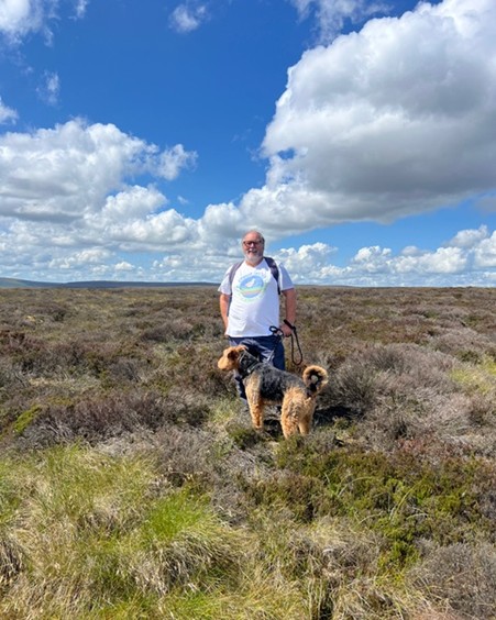
Up at T28, on deep luscious peat that will neither slide nor burst, we find I have left the avalanche probe behind, so for once it is me and the dog in the site photo. If you didn’t know anything about Crow Hill, you might think ///overpaid.arching.common was a suitable site for a wind turbine.
++++++++++++++++++++++++++++++++++++++++++++++++
This is the 62nd in a series of guest blogs originally based on the 65 wind turbines which Richard Bannister planned to have erected on Walshaw Moor.
The developers canned their original 65 wind turbines, quite possibly in response to the public humiliation of having their so-called ‘plan’ publicly shown to be damaging, irrational and probably unlawful. They came back with a plan for 42 wind turbines and the amazing Nick MacKinnon and friends ridiculed that so-called plan. Now the developers have brought forward a 34-turbine revision – the series continues.
To see all the blogs – click here.
[registration_form]
Nice bit of detective work with regards to the photo.
If my memory serves correctly I stayed at Ponden Hall (when I walked the PW). Assuming that my memory is correct, they was a rather irrascible border collie chained up to a building further along the track. Its chain was sufficiently short to spare walkers (or any other passing) either torn clothing or an injury. I suspect that dog will have long since shed its chain and gone to harass angels.
Champion vs North Norfolk sounds like an Alan Partridge episode…
Excellent work again Nick !