
Nick MacKinnon is a freelance teacher of Maths, English and Medieval History, and lives above Haworth, in the last inhabited house before Top Withens = Wuthering Heights. In 1992 he founded the successful Campaign to Save Radio 4 Long Wave while in plaster following a rock-climbing accident on Skye. His poem ‘The metric system’ won the 2013 Forward Prize. His topical verse and satire appears in the Spectator, and his puzzles and problems in the Sunday Times and American Mathematical Monthly. Email: nipmackinnon@gmail.com
Crow Hill Junction SD 95801 36493 ///depth.dampen.showcases
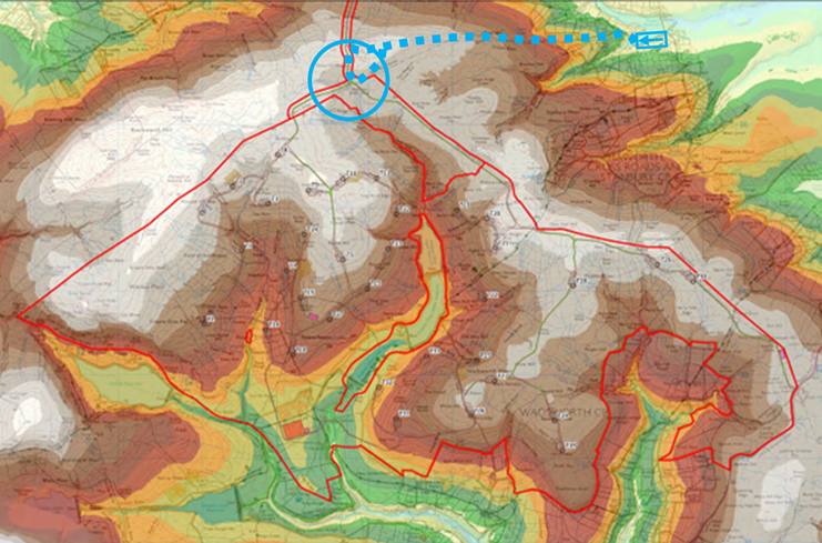
Calderdale Energy Park is on a wholly unsuitable site that would be destructive of outstanding nature and world famous heritage. All this would be made clear in the Examination phase of the DCO, but it would be at huge expense and would require the attention of agencies with much better things to do. CEP is an embarrassment to the policies of the government, and because it is so obviously bad, it will undermine the Net Zero policy. CEP is a venture capital gamble that exploits the desire of the British people to act on climate change. Any political party who oppose renewables can point to CEP as a terrible example, and now that Calderdale Council is run by Reform, they are doing just that and the proposal is an indefensible open goal. Pretending CEP is not on the worst site in England is like pretending Joe Biden was in tip-top cognitive condition.
In my reports to Mustapha Hajjar, CEO of Algihaz, I say that closing down CEP as soon as possible is in the UK national interest. We must not embarrass international investors at a Public Inquiry, but CEP has been managed so incompetently that Algihaz must expect to be humiliated day after day. We must not publicly undermine grid decarbonisation, but CEP is so hopeless that Reform are understandably using it as a whipping boy. We must not undermine the Kunming-Montreal Global Biodiversity Framework, but CEP does exactly that on what is meant to be the pinnacle of internationally designated land.
WTRG have now done the research and supplied the legal framework for two letters-before-action being sent by two different local authorities, each with precise locus standi (relevant connection). One is on the Aggregates, which readers here have been following since Bedlam Knoll in April 2024 and is sent by Colne Town Council and Laneshaw Bridge Parish Council communities which must suffer the unconsulted 616,000 tonnes of non-calcareous hardstone that CWF Ltd have finally admitted they must import. That letter has now arrived in Riyadh and Blyth and it must be answered. The KCs employed by Algihaz will struggle with the specifics and the pushback is expected to be formidable but generic.
Government policy about NSIP consultation changed on 26 July 2026, but these letters-before-action are not rooted in ephemeral government policy but in English common law in respect of Gunning. CWF Ltd held consultations and the claimants say they were not lawful.
The second letter, from Haworth-with-Stanbury Village Council is on Crow Hill, which is the only site in mainland UK to have hosted multiple bog bursts. The formal evidence is the subject of this blog. The PEIR report on peat landslides Appendix 10-4 by AJM of OWC is now completely shredded. AJM missed the 1989 bog slide that was in his own references, Ross 2020 and Dykes & Warburton 2007. The embarrassment is the greater because Professor Jeff Warburton was AJM’s doctoral supervisor and gives a photograph of the 1989 debris that he took in 2005. Among numerous other failings, AJM mixes up the big bog bursts: it is the one on The Wage of Crow Hill that smashes down the Worth and Aire and leaves peat stains in the Humber. The other one is on Crow Hill Wague and as yet undated; the 1989 bog slide is also on Crow Hill Wague. Crow Hill is existential to the proposal but WTRG have shredded the peat landslide report. Christian Egal did his bit by failing to insist that peat depths were taken in advance of the Statutory Consultation.
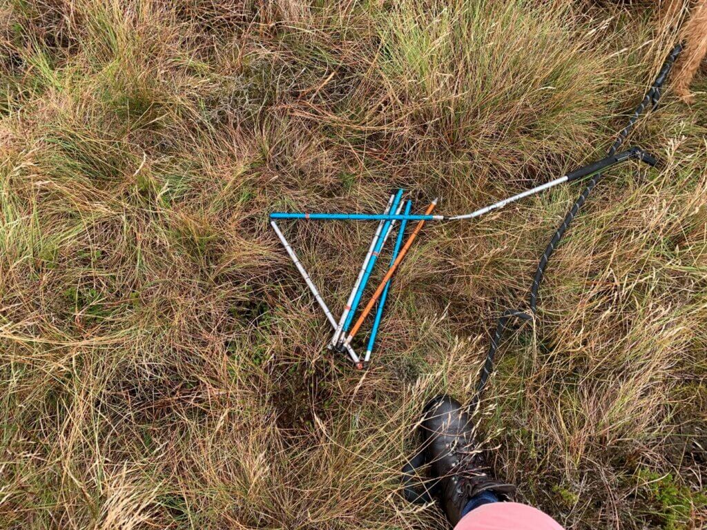
The fiasco on Walshaw Moor has been caused by our society not taking climate change seriously. We leave site choice for wind farms to the very landowners who have pulverised our upland environment. Because our governments are squeamish about using existing law to purchase suitable wind farm sites in the national interest, we have allowed frivolous and incompetent venture capitalists to get quite close to consent for the worst site in England. These venture capitalists propose three heavy haul tracks over the most unstable peat in England on Crow Hill, the source of the only multiple bog bursts in the UK, yet fail to provide their own consultants with the data to assess this unstable ground in time for statutory consultation. Bone-idle incompetence led them to abandon a difficult access route via Halifax in favour of the unstable Crow Hill. They proposed Crow Hill so late that it was impossible for anyone to assess the ground, including their own consultants and they have assembled a legal bomb under their own proposal.
Using the divisive and ignorant rhetoric of former Prime Minister Sir Keir Starmer and his former Chancellor Rachel Reeves, keyboard warriors will say “bats and newts” defeated an NSIP. In fact, incompetent venture capitalists lost control of their own consultants. They made it an unlawful laughing stock.
The bar for a Gunning claim is set high. Legal evidence has to be rigorous and precise and the claimant has to have good locus standi. The claim would be diluted if it was padded with less focused arguments. There is no legal bar to anyone representing generic arguments at a DCO examination but all they will do is take the pressure off the Algihaz KCs.
A Gunning claim can only be made effective (by judicial review) if consent is given by the Secretary of State (presently Miatta Fahnbulleh). The immediate power of the evidence in legal form is that it alters the risk calculus for the venture capitalists and alerts Algihaz of a serious threat to their reputation. We expect intense generic legal pushback on Crow Hill, but since that cannot be based on the admitted ignorance and demonstrated incompetence of PEIR Appendix 10-4, it must be ineffective and counterproductive and will supply further ammunition for judicial review.
In a nutshell, the problem for the Algihaz KCs is that CEP could have come via Halifax but Algihaz preferred the simpler geometry of Colne and Crow Hill, the most potent bog burst location in mainland UK and this inverts the mitigation hierarchy. If CEP survives Examination, gets some kind of positive outcome from the Planning Inspectors and Miatta Fahnbulleh gives consent, she and the Planning Inspectorate will lose at judicial review on the double whammy of unlawful consultations on Aggregates and Crow Hill.
On Crow Hill, Christian Egal, the Inspector Clouseau of Renewables, does all the things that the Planning Inspectorate gently told him not to in their logged opinion and advice, and he does them on the the most unstable peat in England.
What follows is the evidence base for the Gunning letter-before-action, minus 50 footnotes. The actual letter joins the dots explicitly and maps the argument onto case law, which is over 40 years deep. It is the intention of this letter to cause Algihaz to withdraw Calderdale Energy Park in the British national interest, which will also be their own interest.
Evidence that the proposal for Calderdale Energy Park is unlawful under English common law in respect of Gunning.
- Unscoped expansion of CEP red line to Crow Hill
At a late stage, and without a new Scoping Opinion from the Planning Inspectorate (PINS), CWF propose heavy infrastructure on Crow Hill within an unscoped expansion of the site red line.
- Crow Hill is the leading source of repeated bog bursts in the mainland UK
Analysis of the Preliminary Peat Landslide Hazard and Risk Assessment presented by CWF as Appendix 10-4 in their PEIR (8 April 2026) shows that Crow Hill is the leading source of repeated bog bursts in the mainland UK. Bog bursts have far greater consequences than peat slides. These bog bursts occur in the very deep peat on Crow Hill Wague and The Wage of Crow Hill and involve basal peat turning to a pressurised slurry.
- Consequences of a bog burst on Crow Hill
The effects on rivers would be extensive and have been experienced before. Also, the wind farm assets could be stranded; government policies encouraging renewables would be undermined; the event would destroy part of the internationally designated SPA (red-listed birds) and of the internationally designated SAC (peatland habitats) on Walshaw Moor.
- No relevant data were given in the PEIR because none has been gathered
Not only is this proposed extension of the site red line to encompass Crow Hill made at a late stage, but no relevant data had been gathered when Appendix 10-4 was written; therefore none was published in the PEIR for Statutory Consultation; and the author of Appendix 10-4 disclaims analysis on Crow Hill, which he explicitly defers to beyond Statutory Consultation. Furthermore, the timing of the Statutory Consultation (8 April 2026 – 10 June 2026) in the ground-nesting bird season (1 March – 31 July) precluded consultees from collecting relevant data until 1 August 2026. It was not possible for anyone to give Crow Hill intelligent consideration.
- Engineering constraints on CEP proposal
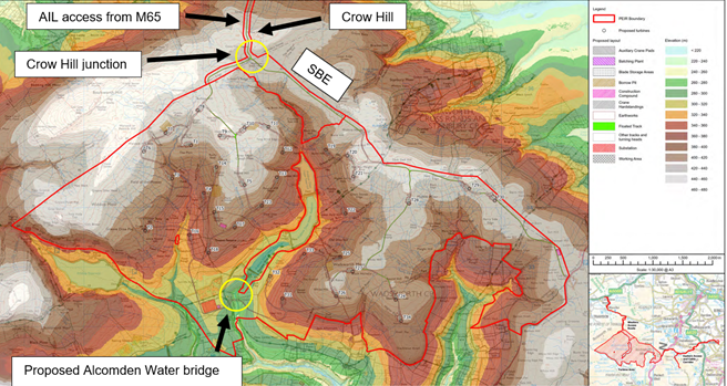
The annotated drawing is on an elevation-shaded base map provided in Appendix 10-4. The red line expansion is in the area at the north, between the former red line and Crow Hill. The CEP site is divided by the Walshaw Dean reservoirs in a steep-sided valley. Delivery of turbine components from the proposed single point of entry at the north of the site (served eventually by the M65) requires a crossing of Walshaw Dean divide. Two crossings are presently proposed in PEIR and are shown in the yellow circles.
- A bridge over Alcomden Water
- Crow Hill junction with a floating track over the very deep peat of Red Mires Flat and Middle Moor Flat. This track is called “the Stanbury Bog Expressway” (SBE) in the published analyses. The SBE requires the extension of the original red line as shown in the map.
The proposal as configured cannot be built without :
- Access over Crow Hill from the M65 for the 31 wind turbines, the 33kV/132 kV onsite transformers and 616,000 tonnes of non-calcareous hardstone that cannot be won onsite.
- A crossing of Walshaw Dean, either at the Crow Hill junction or at Alcomden Water.
A half-size wind farm might be proposed west of the divide without a crossing but this would be a materially different proposal and at c. 130 MW could probably not sustain the cost of the specified buried 132 kV cable to Bradford West, some 18 km distant. There is doubt over the practicality of the Alcomden Water crossing and CWFL consultant Donald Mackay told Nick and Lydia MacKinnon at Haworth (19 May 2026) that, “I double up. I need that access across Stanbury Bog in case they don’t let me have Alcomden bridge.” Donald Mackay is held in the highest regard for his consistent frankness about engineering realities.
- Peat slides and bog bursts
Appendix 10-4 has very serious specific errors of fact and specific methodological flaws which are described in 11-13. However, its generic methods are standard and we follow them. Direct quotations from Appendix 10-4 are distinguished by a blue font.
Peat Instability in the UK and Ireland
In October 2003, a peat failure occurred on an afforested wind farm site in Derrybrien, County Galway, Ireland, causing disruption to the site and large-scale fish kill in the adjoining watercourses (Lindsay and Bragg, 2004). The Derrybrien event triggered interest in the influence of wind farm construction and operation on peatlands, particularly in relation to potential risks arising from construction induced peat instability. In 2007, the (then) Scottish Executive published guidelines on peat landslide hazard and risk assessment in support of planning applications for wind farms on peatland sites in Scotland. The guidance has been in use since then and was updated in 2017. Since then, a number of peat landslide events have occurred both naturally and in association with wind farms. In the case of wind farm sites, these have rarely been reported, however in December 2016, a plant operator was killed during excavation works in peat at the Derrysallagh wind farm site in Co. Leitrim (Flaherty, 2016) on a plateau in which several published examples of instability had been previously reported.
The Derrybrien event is the subject of an extensive report by Richard Lindsey and Olivia Bragg. Following the event, An Bord Pleanála refused substitute consent for the wind farm in February 2022 and a subsequent enforcement notice issued and served from Galway County Council in August 2024 means that the whole wind farm (70 turbines 59.5 MW) must be decommissioned. The source of the Derrybrien peat landslide had not produced any previous events, let alone the repeated events on Crow Hill from 1824-1989.
- Types of Peat Instability
For the purposes of this assessment, landslide classification is simplified and split into three main types. […]
The term “peat slide” is used to refer to large-scale (typically less than 10,000 of cubic metres) landslides in which failure initiates as large rafts of material which subsequently break down into smaller blocks and slurry. […] The term “bog burst” is used to refer to very large-scale (usually greater than 10,000 of cubic metres) spreading failures in which the landslide retrogresses (cuts) upslope from the point of failure while flowing downslope. […] Bog bursts are rarely (if ever) reported in the UK, other than in the Western Isles of Scotland (e.g. Bowes, 1960), and notably, immediately to the north of the Turbine Area. (Appendix 10-4.2.2)
In fact, Appendix 10-4 divides peat landslides into peat slides and bog bursts. Bog bursts are the most destructive kinds of peat landslide in which basal peat turns into liquid slurry; the Crow Hill junction of CEP is in the middle of the source of most of the bog bursts recorded in the UK; all of the turbine components and 616,000 tonnes of hardstone must be delivered across Crow Hill; yet CWF have failed to provide for Statutory Consultation the required peat depth data and therefore any adequate analysis of Crow Hill. Appendix 10-4 is clear that the analysis of bog burst risk is different from the much more common peat slide risk.
Further analysis of Crow Hill on the lines laid out by Appendix 10-4 shows the problems are even more significant. Failures by the author of Appendix 10-4 to master his own references, or to refer to the Scoping Opinion adopted by the Secretary of State (adopted 10 October 2025), in which Haworth-with Stanbury Council laid out the scope of the problem on Crow Hill, makes the CWF consultation deficit more culpable and exposes Algihaz to reputational risk.
- Crow Hill disclaimer by AJM
The spatial scope of this PPLHRA at PEIR is limited to the Turbine Area within which turbines are proposed and does not extend to covering the Access Routes nor the Bradford West Cable Corridor, as shown in Plate 1.1. These components of the Proposed Development will be assessed once supporting peat depth data is available.
Although AJM admits that Crow Hill is beyond the spatial scope of his report, he is compelled to make some analysis of the Crow Hill bog bursts because they are so close to the turbine area and so significant in extent and consequences as to be famous. The Crow Hill bog bursts are much more significant than peat landslide risks inside the turbine area because the latter can be mitigated by moving the infrastructure, which is called “micrositing”; or by simply removing a turbine. The Crow Hill infrastructure cannot be microsited or removed because it is existential to the whole proposal. Analysis of Crow Hill instability should therefore have preceded analysis of the turbine area. This point was made by several statutory consultees in the Scoping Opinion adopted by the Secretary of State on 10 October 2025, including Haworth-with-Stanbury PC, and is an aspect of the Overarching Opinion of PINS concerning extension of the site boundary red line.
- Response of Haworth-with-Stanbury PC to CEP Scoping Report
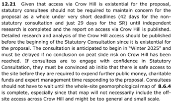
As it turned out, the Statutory Consultation was delayed from “Winter 2025” suggested at Scoping until 8 April 2026. There was therefore ample time to do the necessary peat probing on Crow Hill. We estimate that two days on-site work would have sufficed.
- Scoping Opinion of Planning Inspectorate
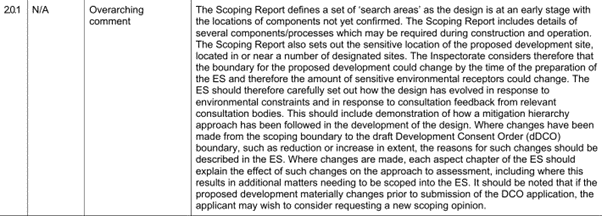
We analyse this Overarching comment by PINS in 20 below. The extension of the proposal onto the unique bog burst terrain of Crow Hill constitutes a potentially dangerous material change to the development and the applicant should certainly have requested a new scoping opinion from PINS. In their responses to the request, the consultees would require full data and independent analysis of Crow Hill. It would only have taken a few days to extend the existing peat depth survey to Crow Hill, so the failure to supply data in the PEIR for Statutory Consultation should already have been explained and justified by CWF and has not been.
- PEIR Appendix 10-4 mixes up the bog bursts
Although AJM has disclaimed Crow Hill in the PEIR analysis of peat landslides, the Crow Hill events are so significant, and so close to the turbine area that some comment is required. Because AJM has failed to master the references that he uses (Ross 2020 and Dykes & Warburton 2007) he mixes up the earlier bog bursts and misses out the 1989 bog burst entirely.
Outside the Turbine Area to the north, the Crow Hill bog burst (a much reported peat landslide, documented by Rev. Patrick Brontë (Ross, 2020) is located to the west of the Western Access Route. The landslide took place in 1824 (c. 200 years ago), and remains visible in the landscape (Plate 3.3d). It occurs within gently sloping peatland drained by Crow Hill Beck and is likely to have been triggered by sidewall collapse of the watercourse, possibly during a spate event. […] While bog burst features do not typically ‘reactivate’ (start moving again), the presence of past landslides in an area of peatland can be an indicator that a site or area is susceptible to this form of instability – possibly because the successional vegetation history that governs the physical characteristics of the peat is similar in a particular locality. A similar feature is located in Stanbury Bog to the southeast of Crow Hill. Its morphology (form) is less clear than that of the Crow Hill burst and it may be of a similar age (i.e. not recent).
The tendency of this paragraph is to minimise the bog burst problem on Crow Hill. The statutory consultees did not need the prompt “(c. 200 years ago)” to help them with subtracting 1824 from 2026. The paragraph uses a reference, Ross 2020. This is Charlotte Brontë at the Anthropocene by Associate Professor Shawna Ross of Texas A&M University. Ross 2020 is the master account of the 1824 bog burst on Crow Hill, which was witnessed directly by Emily (6) and Anne (4) Brontë while on a walk with their nursemaids Nancy and Sarah Garrs. The bog burst occurred at about 6 p.m. Thursday 2 September 1824. The witnesses were below the source, heard the torrent of peat, water and boulders above them, and were able to find safe ground near Ponden Hall while a river of debris over two metres deep poured past them. Rev. Patrick Brontë reported another bog burst in the Leeds Intelligencer on 16 September. J. Horsfall Turner recorded four separate bog bursts on 9 September 1824.
Appendix 10-4 states this September 1824 bog burst complex is “west of the western access route”. It then describes a second bog burst SE of Crow Hill on Stanbury Bog. Had AJM mapped these bog bursts he would have understood that it is the Stanbury Bog event that was on 2 September 1824. AJM has not mastered his own reference Ross 2020 and there is extensive further evidence in the public domain that he did not consult Ross 2020 directly.
- Maps of the bog bursts cited by AJM and missing 1989 bog slide
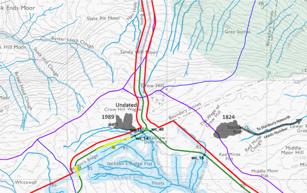
The bog bursts on Crow Hill are visible in the landscape and especially on LIDAR maps. AJM in Appendix 10-4 fails to make a map of recorded bog bursts, so he fails to discover that the 1824 event known as the Crow Hill Bog Burst started between the bogs known as The Wage of Crow Hill and Stanbury Bog. Peat slurry exploded under pressure and a deep river of peat, water and boulders poured down Red Mires Clough, accelerated over the cliff on Ponden Clough and poured down the Worth through Stanbury and Haworth. At Keighley the peat slurry entered the Aire, and at Leeds the reservoir pumps were turned off. The Aire enters the Ouse at Goole, which drains to the Humber, and peat stains were reported in the Humber Estuary.
- PEIR misses the 1989 bog slide reported in its own references
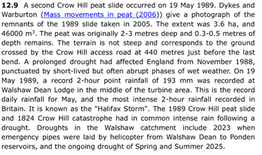
There is multiple evidence that AJM did not consult a copy of Ross 2020 or read Dykes and Warburton 2007 with attention before he wrote Appendix 10-4 and this explains his mixing up the bog bursts. The most important evidence is that AJM entirely misses the 1989 Crow Hill bog burst/slide described by Ross on p67-68. Ross gives a reference to Dykes & Warburton 2007 which she says has a photograph of the remains of the 1989 Crow Hill bog slide, taken by Warburton in 2005.
Not only does AJM miss this 1989 bog burst in Ross, 2020, but he also misses it in Dykes & Warburton 2007, a paper of 21 pages to which AJM makes seven dispersed references in Appendix 10-4. The relevant page is shown below.
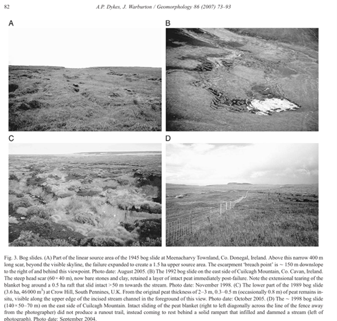
This 1989 Crow Hill “bog slide” had an estimated volume of 46,000 m3 and is on low gradient terrain. It falls into the bog burst category (>10,000 m3) of Appendix 10-4 which deals in peat slides and bog bursts as the modelled categories.
Consideration of the 1989 bog burst/slide is essential because it shows the bog burst hazard on Crow Hill is not limited in time. It was negligent of AJM not to read his own references. This caused him to write misleadingly about the Crow Hill bog bursts as being distant in time. Appendix 10-4 of the PEIR should be explicitly withdrawn by CWF, who were sent a formal notification of this and other defects in the appendix by WTRG on 8 June 2026. PINS acknowledged receipt on 18 June 2026.
- 1989 bog burst evidence was set out in detail by Haworth-with-Stanbury PC
The failure of Appendix 10-4 to discover the 1989 bog burst in its own references is made more culpable because it was fully referenced with analysis in the Scoping Opinion Appendix 2 given here in screenshot for evidential purposes, submitted by Haworth-with-Stanbury PC and several other statutory consultees, and adopted by the Secretary of State on 10 October 2025.
- Bog bursts are rare in England except on Crow Hill
AJM admits that bog bursts in England are concentrated on Crow Hill.
Stability of the westernmost bog burst has yet to be assessed in detail, but will be post-PEIR. Both bog bursts are outliers in the reported population of landslides in England, which are largely focused in the North Pennines, with few if any other landslides reported in the South Pennines.
In fact the “westernmost bog burst” has not been assessed at all in the PEIR, let alone “in detail”, because AJM has mixed it up with the 2 September 1824 bog burst between the Wage of Crow Hill and Stanbury Bog. Had AJM read Ross 2020 he would have found the 1989 bog burst and the reference to Jeff Warburton’s photograph of it. AJM’s culpability in not mastering his own references is not reduced by his being the doctoral student of Professor Warburton. Any consultee who did not make their own map of the events AJM describes would know less about them after reading Appendix 10-4 than they did before.
Dykes & Warburton tabulate the historical frequency of peat landslides in the UK and Ireland and gives a table by country. The 1989 bog slide is classified as a peat slide in this table.
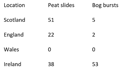
All the recorded bog bursts in England took place on Crow Hill, where in 1989 there was also a 45,000 m3 bog slide. The 1824 event had six recorded bog bursts in total.
- The assessment method for bog bursts in Appendix 10-4 is therefore invalid on Crow Hill
Appendix 10-4 uses factor of safety and susceptibility scoring metrics to assess peat slide and bog burst likelihoods on 49,500 slope facets and shows the results in a coloured map. The susceptibility scoring uses a variety of aspects (peat depths, drainage, slope curvature … ) individually scored and summed. The method is sophisticated, especially in its graphical display and may be useful in finding the sources of potential peat slides in the turbine area where there have been no significant peat landslides recorded. However, it is invalid to use the method to assess bog burst likelihood in an area that has already hosted multiple bog bursts. The scoring system has no input for pre-existing bog bursts near a facet. The scoring cannot accommodate this major factor because bog slides/bursts are very unusual in England but common on Crow Hill.
In terms of mathematical probability, the susceptibility scoring is relative to the normal background of bog bursts but is being applied on a site with an extraordinary Bayesian prior distribution of bog bursts.
The concept of Bayesian prior distribution is familiar in the screening for rare diseases. Suppose 0.001% of the population has a rare disease D for which there is a test. If a person has D, the test is positive 99% of the time, but it gives a false positive to 3% of people who do not have D.
If the test screens 50 million people, among the 500 people who have D, 495 will receive a positive test and 5 a false negative. However 1,499,985 people who do not have D will be given a false positive test result and these swamp the people who actually need treatment for D.
Now suppose a symptom S such that 60% of people who report S have the rare disease D. If the test is given to 100 people with S, at most one person with D will get a false negative test, and only one person will get a false positive. S changes the Bayesian prior distribution.
Bog burst distribution on the mainland UK is extremely unusual. In the 244,376 km2 of England, Scotland and Wales, Warburton counts seven bog bursts. (Bog bursts are a “rare disease D” in the population of square kilometres.) Two of them (and the 1989 bog slide) have been on one square kilometre of Crow Hill (“Being on Crow Hill” is the key symptom S.)
It is thus entirely invalid to assess a UK facet for bog burst likelihood using the test scores described in 10-4 without first narrowing the Bayesian prior distribution by asking: “Is this facet on Crow Hill? Y/N” The process may be standard, but its application is invalidated on Crow Hill because of the extreme prior distribution.
- Specific explanation of bog burst distribution on Crow Hill
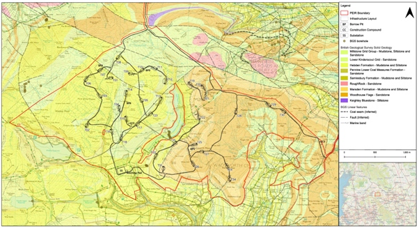
PEIR figure 10-08a shows the proposed infrastructure on a map of the solid geology. Crow Hill is the purple comma at the top. All of the map except Crow Hill shows the typical gritstone bed rock of Lancashire and West Yorkshire. These gritstones are porous. The remarkable exception is Crow Hill, whose bed rock is Keighley Blue, a rock named after the nearest large town to Crow Hill, and found nowhere else. Keighley Blue is an exceptionally well cemented impermeable siltstone, shaly in appearance. Its strength and low porosity made it valuable as a local roadstone, in contrast to the weak and porous aggregates made from the almost universal gritstones.
The explanation for the uniqueness in mainland UK of Crow Hill as a multiple bog burst/slide host lies in this unique geology shown in the map below
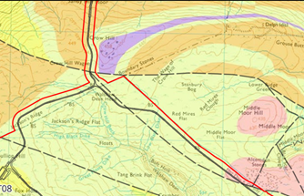
The map above shows the unique impermeable Keighley Blue of Crow Hill. The CEP track from the north is the sole proposed delivery route for the turbine components from the M65 at Colne. The track must also carry the whole 616,000 tonnes of non-calcareous hardstone aggregate that is required to build the tracks. Two other floating tracks converge at the Crow Hill junction. Both tracks cross the Crow Hill bog burst source area, which has had up to eight of nine UK bog bursts between 1824 and 1989.
The Crow Hill discontinuity is visible in the landscape as a vegetation and slope change. Keighley Blue can be seen like shaly garden feature.
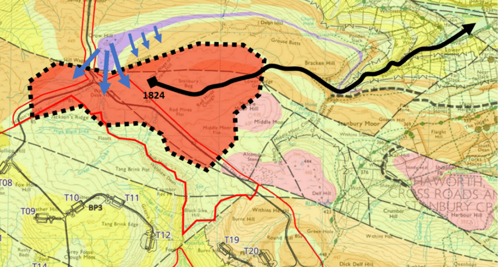
Heavy rainfall on Crow Hill drains through the thin peaty soil and finds the impermeable Keighley Blue. All the other rock in the map is porous sandstone, typically saturated. Runoff then moves along the shear plane between peat and Keighley Blue until it reaches the flat areas of Crow Hill Wague and the Wage of Crow Hill which connect with Stanbury Bog and are shaded in red above. This injection along the shear plane raises the hydrostatic pore pressure in the very deep peat (400-500 cm) of Wague and Wage. The red area with the dotted boundary is the only source of multiple bog bursts/slides on the mainland UK (1824-1989). The black arrow shows the route of the catastrophic bog burst of September 1824.
The three proposed floating tracks converge on the Crow Hill junction. Their aggregate has a density of 2.2 tonnes/m3 and the weight raises pressure in the peat/water substrate until it can support: the track itself; the frequent 30 tonnes gross aggregate deliveries; and the occasional 110 tonne weight of a nacelle delivery. The three floating tracks inevitably increase pore pressure in the bog burst source area, particularly in very high rainfall where there will be ponding at the tracks because the track compresses the pore structure of the peat.
The Crow Hill junction is inside the only one km2 area that has ever hosted a bog burst in the mainland UK; in fact eight bog bursts/slides have been recorded here between 1824 and 1989, six in 1824, one undated on Crow Hill Wague, and a bog slide in 1989 on Crow Hill Wague; and the proposed infrastructure will increase the risk of a bog burst. This first principles analysis is supported strongly by the preconditioning and triggering factors stated in PEIR 10-4 and laid out below.
- Preconditioning and triggering factors for bog burst
Peat landslides are caused by a combination of factors – triggering factors and preconditioning factors (Dykes and Warburton, 2007; Scottish Government, 2017). Triggering factors have an immediate or rapid effect on the stability of a peat deposit whereas preconditioning factors influence peat stability over a much longer period. Only some of these factors can be addressed by site characterisation.
Preconditioning factors may influence peat stability over long periods of time (years to hundreds of years), and include:
i ] Impeded drainage caused by a peat layer overlying an impervious clay or mineral base (hydrological discontinuity).
ii] A convex slope or a slope with a break of slope at its head (concentration of subsurface flow).
iii] Proximity to local drainage, either from flushes, pipes or streams (supply of water).
iv] Connectivity between surface drainage and the peat/impervious interface (mechanism for generation of excess pore pressures).
v] Artificially cut transverse drainage ditches, or grips (elevating pore water pressures in the basal peat-mineral matrix between cuts, and causing fragmentation of the peat mass).
vi] Increase in mass of the peat slope through peat formation, increases in water content or afforestation.
vii] Reduction in shear strength of peat or substrate from changes in physical structure caused by progressive creep and vertical fracturing (tension cracking or desiccation cracking), chemical or physical weathering or clay dispersal in the substrate.
viii] Loss of surface vegetation and associated tensile strength (e.g. by burning or pollution induced vegetation change).
ix] Increase in buoyancy of the peat slope through formation of sub-surface pools or water filled pipe networks or wetting up of desiccated areas.
x] Afforestation of peat areas, reducing water held in the peat body, and increasing potential for formation of desiccation cracks which are exploited by rainfall on forest harvesting.
Of these ten preconditioning factors:
i] describes exactly the stark hydrological discontinuity between Crow Hill Keighley Blue and permeable gritstones below on the Wague and Wage.
ii] describes exactly the convex slope of the Crow Hill summit running into the flat Wage and Wage
iii] describes exactly the water-supplying function of Crow Hill summit, especially in a storm.
iv] the connectivity between the impervious and porous geology forms the shear plane
v] the floating tracks road will be served with transverse ditches and themselves act as drains. Figure 10.4.5 of Appendix 10 shows the intense artificial ditching already present.
viii] and ix] also describe Crow Hill.
Triggering factors are typically of short duration (minutes to hours) and any individual trigger event can be considered as the ‘straw that broke the camel’s back’
i] Intense rainfall or snowmelt causing high pore pressures along pre-existing or potential rupture surfaces (e.g. between the peat and substrate).
ii] Rapid ground accelerations (e.g. from earthquakes or blasting).
iii] Unloading of the peat mass by fluvial incision or by artificial excavations (e.g. cutting).
iv] Focusing of drainage in a susceptible part of a slope by alterations to natural drainage patterns (e.g. by pipe blocking or drainage diversion).
v] Loading by plant, spoil or infrastructure.
Of the five triggering factors given, only ii] is not specially relevant, with i], iv] and v] exact descriptions of what is proposed. In iv] “pipe” refers to the natural drainage channels in peat called “peat pipes”.
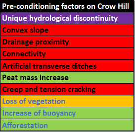
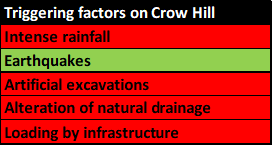
In summary, using the pre-conditioning and triggering factors of Appendix 10-4, Crow Hill Wague and the Wage of Crow Hill would be vulnerable to bog bursts if wind farm infrastructure were built on them even if they had not already hosted two bog bursts and one bog slide. It is the unique hydrological discontinuity of the Crow Hill Keighley Blue that has the greatest explicative power for the uniqueness of Crow Hill in England’s recorded bog bursts.
- CEP proposal has been through three consultations with a red line avoiding Crow Hill
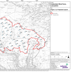
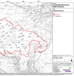
The maps show the site boundary on maps dated 31 July 2023 (CWF) and 17 April 2025 (CEP) avoided Crow Hill. Note that T17 and T23 in the 2023 layout are pulled back from Crow Hill in the 2025 layout.
Analysis of Overarching comment of Planning Inspectorate adopted 10 October 2025
The red line in 19 was consulted in September 2023 (CWF Scoping Consultation), April 2025 (Non-statutory Consultation) and September 2025 (CEP Scoping Consultation). In its Scoping Opinion, PINS made the following overarching comment which we now analyse in detail relative to Crow Hill.
“The Scoping Report defines a set of ‘search areas’ as the design is at an early stage with the locations of components not yet confirmed. The Scoping Report includes details of several components/processes which may be required during construction and operation. The Scoping Report also sets out the sensitive location of the proposed development site, located in or near a number of designated sites. The Inspectorate considers therefore that the boundary for the proposed development could change by the time of the preparation of the ES and therefore the amount of sensitive environmental receptors could change. The ES should therefore carefully set out how the design has evolved in response to environmental constraints and in response to consultation feedback from relevant consultation bodies. This should include demonstration of how a mitigation hierarchy approach has been followed in the development of the design. Where changes have been made from the scoping boundary to the draft Development Consent Order (DCO) boundary, such as reduction or increase in extent, the reasons for such changes should be described in the ES. Where changes are made, each aspect chapter of the ES should explain the effect of such changes on the approach to assessment, including where this results in additional matters needing to be scoped into the ES. It should be noted that if the proposed development materially changes prior to submission of the DCO application, the applicant may wish to consider requesting a new scoping opinion.”
- a) “The Scoping Report defines a set of ‘search areas’ as the design is at an early stage with the locations of components not yet confirmed. The Scoping Report includes details of several components/processes which may be required during construction and operation.”
The access track up the steep north face of Crow Hill and across Crow Hill Wague and Wage of Crow Hill is required during construction for the delivery of all the turbine components, the 33 kV/132 kV transformers and 616,000 tonnes of imported noncalcareous aggregate, including railway ballast.
- b) “The Scoping Report also sets out the sensitive location of the proposed development site, located in or near a number of designated sites.”
The areas added to the original red line are all inside the internationally designated SPA and SAC. They are on the Brontë Moor which is prima facie the statutory setting of the Grade I listed Haworth Parsonage; Crow Hill is one of the most significant Brontë sites.
- c) “The Inspectorate considers therefore that the boundary for the proposed development could change by the time of the preparation of the ES and therefore the amount of sensitive environmental receptors could change.”
The amount of sensitive environmental receptors has greatly increased. In addition a new hazard, bog burst, has been introduced because Crow Hill is the only recorded source of bog bursts in England.
- d) “The ES should therefore carefully set out how the design has evolved in response to environmental constraints and in response to consultation feedback from relevant consultation bodies. This should include demonstration of how a mitigation hierarchy approach has been followed in the development of the design. This should include demonstration of how a mitigation hierarchy approach has been followed in the development of the design.”
The extension onto the known hazards and triple designations of Crow Hill is not the result of a mitigation hierarchy. It is because the Option A access through Halifax that voids Crow Hill is awkward geometrically, but not particularly so. It is analysed in 23 below.
The PEIR does not explain how the red line extension has evolved in response to environmental constraints. The extension is in response to engineering constraints (Halifax, Alcomden Bridge) that should have been anticipated at due diligence in November 2021 and before the launch of CEP in April 2025. The mitigation hierarchy has been overturned: inconvenience in Halifax has been treated as trumping repeated bog bursts on Crow Hill.
- e) “It should be noted that if the proposed development materially changes prior to submission of the DCO application, the applicant may wish to consider requesting a new scoping opinion.”
The extension onto Crow Hill, a hazardous and triply designated site for SPA/SAC/Heritage is a major material change, unconsulted between the Scoping Opinion (10 October 2025) and the PEIR (8 April 2026) that requires a new scoping opinion.
- A track over Crow Hill was rejected by Natural England on grounds of the Habitats Regulations in 2019
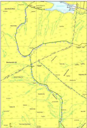
Following legal action led by Dr Mark Avery, Natural England withdrew consent for a track over Crow Hill. The track is removed from the 2017-2042 Walshaw Moor Catchment Restoration Plan MRP 002 by the addendum dated 4 March 2019. The proposed track was shown as below in the original plan.
- Section 51 advice of PINS to CWFL logged 15 July 2026
“Environmental constraints and issues: The Inspectorate advised the applicant on the importance of clearly explaining the site selection process, including approach to alternatives, in both the consultation and application documents.”
No clear explanation has been given for the choice of Walshaw Moor, the most extreme site in England on the axes of SPA/SAC/globally famous heritage. The next most extreme site is Ashdown Forest. No clear explanation has been given for the choice of a site with no hardstone aggregates available on site, and which is the only locus of repeated bog bursts in England.
There were also alternatives for access from the motorway network: M62 via Halifax and Cock Hill A6033; and M65 via Colne, C682 and Crow Hill. No explanation has been given for the abandonment of the Halifax alternative for turbine component delivery in favour of the known hazards of Crow Hill.
- Halifax alternative has finite difficulties
The Halifax option was described in the Non-statutory Consultation brochure as Option A and follows the route of the Ovenden blades which were 40-metres long. Delivery of 80-metre blades via Halifax requires the following treatment of pinchpoints.
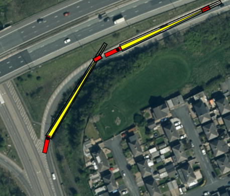
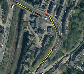
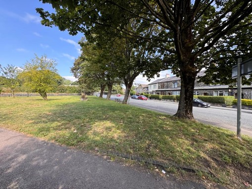
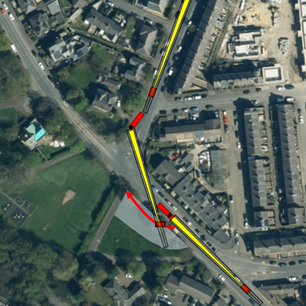
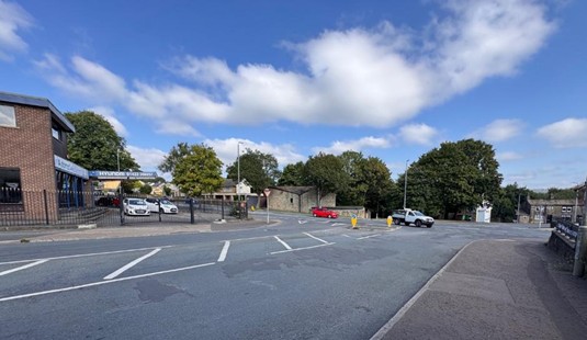
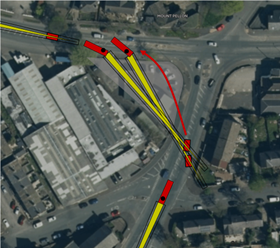
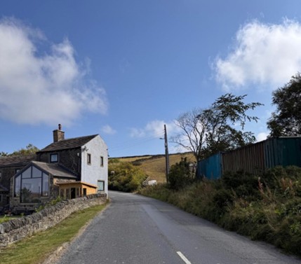
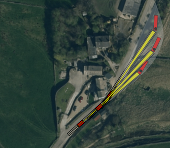
Beyond Dale View Farm the improvements required are already scheduled for the cable corridor.
Colne alternative has indeterminate and indefinite complexities on Crow Hill extending throughout the proposal lifetime
The C682 Lancashire Moor Rd requires a bypass because the bridge at Laneshaw Bridge is not suitable and School Lane beyond road is too sinuous and narrow. The expense and destructiveness of this bypass are likely to exceed that of the works needed via Halifax. Land has to be purchased from a range of landowners.
The complexities on Crow Hill are indefinite in difficulty because of peat slide risk on the steep ascent and the known bog burst hazard on Crow Hill Wague and the Wage of Crow Hill. The liabilities are indefinite, extending beyond the site lifetime. The land on the Lancashire side of Crow Hill (LA518044) has to be purchased from the Walshaw Moor Estate as Algihaz have no option on it. Algihaz have had an option on all the land in the extended red line on the Yorkshire side (YY196927 and WYK72194 which includes Crow Hill Wague and Wage) since 11 November 2021 (larger circle)
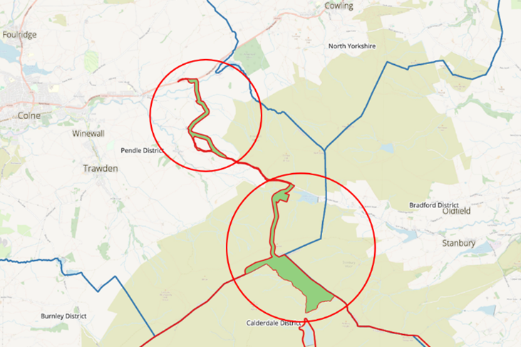
No reasons have been published for the rejection of Option A via Halifax in preference to Option B via Colne and the indefinite hazards of Crow Hill described here.
- Engineering complexities of Alcomden Water crossing
The infrastructure on The Wage of Crow Hill may be covering anticipated difficulties in the Walshaw Dean crossing at Alcomden Water. The PEIR crossing has a bridge at the bottom of the steep sided valley. This bridge requires a 27% descent and 18% reascent travelling west-east.
- Conclusion
There is no precedent in the mainland UK for heavy duty infrastructure being consented on land with such a known high frequency of bog bursts as Crow Hill.
CWF had a safe alternative delivery route through Halifax for the turbine components which was abandoned without explanation. Analysis shows the Halifax route to be feasible and less expensive than the chosen route over Crow Hill. In choosing Crow Hill over Halifax, CWF inverted the mitigation hierarchy.
The Crow Hill route exposes the developer, the subsequent owner, the insurers, the environment and the people of Haworth and Stanbury to unnecessary indefinite risk from catastrophic bog burst.
Crow Hill and wider Walshaw Moor is triply designated as a Special Protection Area, a Special Area of Conservation and prima facie as the statutory setting of the Grade I listed Brontë Parsonage. It is by those criteria demonstrably the most extreme site for a wind farm in England. Crow Hill is itself the site of the 1824 bog burst which threatened the lives of Emily and Anne Brontë as children and is thus in itself a site of especial heritage value for precisely the same reason that it is so hazardous a site for wind farm infrastructure.
Algihaz own an option on Crow Hill, but carefully drew the red line of their proposed wind farms so that it avoided Crow Hill. Only in the fourth consultation was the red line extended to encompass Crow Hill, yet no relevant information to justify the extension was provided.
The Preliminary Peat Landslide Hazard and Risk Assessment confused the bog bursts that it discusses; failed to master its references; failed to discover the 1989 Crow Hill bog slide despite there being a photograph of it in its main reference; and admitted that no proper assessment could be made because the peat depths had not been found.
The Planning Inspectorate have already suggested that following material change to the red line in the area of Crow Hill the developers may wish to consider requesting a new scoping opinion.
The Planning Inspectorate have logged advice to CWF about the importance of clearly explaining the site selection process, including approach to alternatives, in the consultation documents. There has been no clear explanation in any of the consultation documents of why Calderdale Energy Park chose the hazardous Crow Hill access rather than the Halifax option which is free of known and famous bog burst hazard.
- Remedy
Given the conclusions, all of which are justified by extensive and multi-disciplinary evidence, CWF should:
- withdraw the PEIR proposal for Calderdale Energy Park;
- prove there is no alternative site to Walshaw Moor;
- if there is indeed absolutely no alternative, redesign the proposal to avoid Crow Hill;
- and reconsult.
It should be noted that it has been Haworth-with-Stanbury Parish Council and their consultants WTRG who alerted CWF and the Planning Inspectorate to this hazard; who identified the serious errors and omissions in the PEIR Preliminary Peat Landslide Hazard and Risk Assessment; and who have written this extensive analysis. Haworth-with-Stanbury PC and WTRG should be among the consultees for any subsequent proposal.
All the evidence in this document has been published as it has been found in WTRG blogs titled Walshaw Turbines and published on Dr Mark Avery’s site. This analysis will be the multi-disciplinary evidence base for a letter-before-action from Haworth-with-Stanbury Village Council claiming that the consultations into Calderdale Energy Park held by CWF and financed by Algihaz Holding were unlawful under English common law in respect of Gunning.
++++++++++++++++++++++++++++++++++++++++++++++++
This is the 61st in a series of guest blogs originally based on the 65 wind turbines which Richard Bannister planned to have erected on Walshaw Moor.
The developers canned their original 65 wind turbines, quite possibly in response to the public humiliation of having their so-called ‘plan’ publicly shown to be damaging, irrational and probably unlawful. They came back with a plan for 42 wind turbines and the amazing Nick MacKinnon and friends ridiculed that so-called plan. Now the developers have brought forward a 34-turbine revision – the series continues.
To see all the blogs – click here.
[registration_form]
I’m trying to make sense of the information about the Haworth with Stanbury Village Council’s upcoming legal challenge on Gunning grounds to Calderdale Energy Park’s recent statutory consultation.
The blog post notes that a Gunning claim can only be made effective (by judicial review) if consent to Calderdale Energy Park’s Development Consent Order application is given by the Secretary of State. So the immediate purpose of the Haworth with Stanbury Village Council legal challenge is to “alter the risk calculus” for investors and get Al Gihaz to withdraw the Calderdale Energy Park proposal.
Ok, that’s a clear enough statement of intention. The Village Council is basically taking a gamble on the assumption that the prospect of a judicial review once the DCO was approved by the Sec of State, would be a sufficient deterrent to Al Gihaz, that they would withdraw the Calderdale Energy Park proposal now (or possibly during the DCO Examination, if I’m reading the blog post right).
What I don’t understand is the blog post’s apparent claim that anyone representing “less focused..generic arguments” at a DCO examination will “take the pressure off the Algihaz KCs”.
Is the Walshaw Turbines Research Group saying that the evidence presented in the Haworth with Stanbury legal challenge (and presumably also the aggregates issue in the Laneshawbridge Parish Council and Colne Town Council’s legal challenge) is the only evidence that interested parties who reject the proposed development should make in the DCO examination, if it happens?
Because that seems to be the implication – but it seems so outlandish that I think I must be misreading it. Please clarify what is meant here. It’s quite important. If the Planning Inspectorate accepts Calderdale Energy Park’s DCO application for examination, anyone who wishes to register as an interested party has to submit comments/ a preliminary relevant representation, about what they think are the key issues/impacts of the proposed development. Is the Walshaw Turbines Research Group saying that interested parties’ preliminary relevant representations should only identify the aggregates issue and the northern access route across Crow Hill, as key issues for examination?