If you look at the Ordnance Survey map at grid reference SD 944344 – use this link.
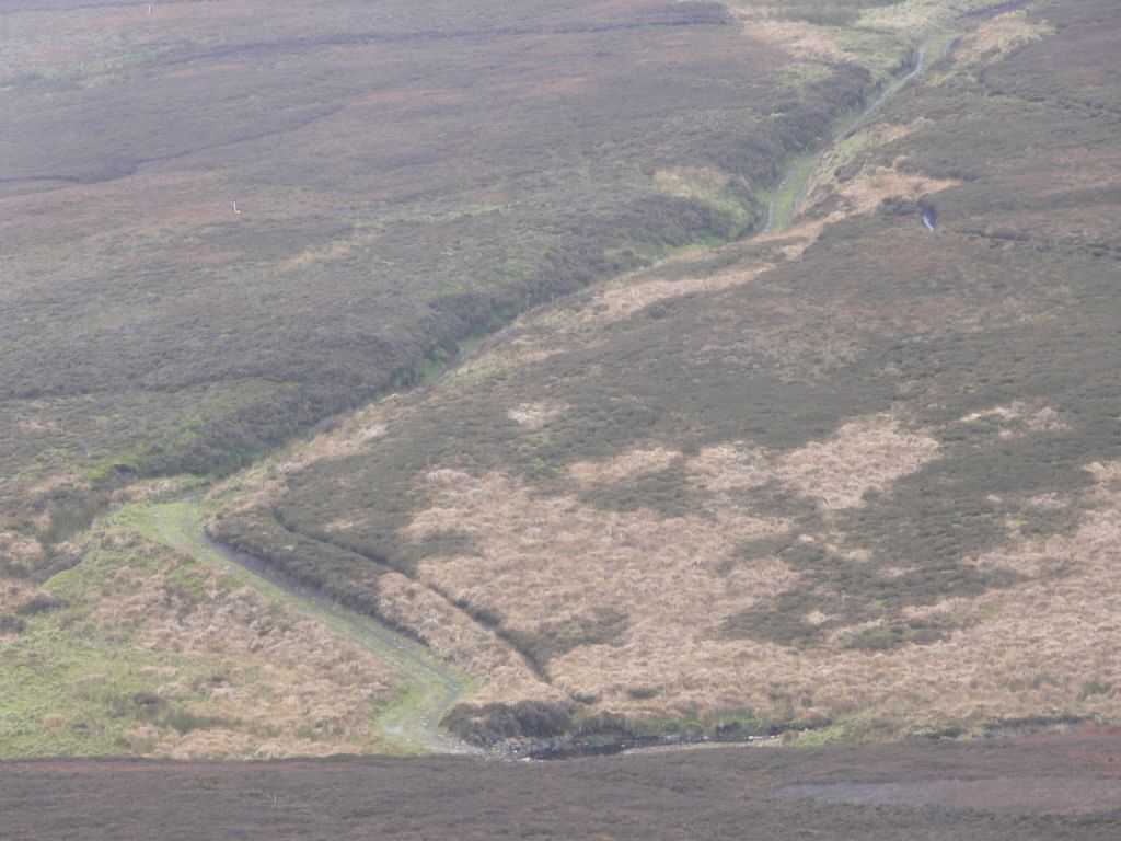
Can you see that there is an unnamed stream (a watercourse) between one called Foul Sike (to the north) and another called Waterfall Syke (to the south)?
Here it is these days – looks a bit like a track doesn’t it?
And if you’d like to look for signs of this track on Google Earth, do! You’ll find the track on the image 1 June 2009, and the image 17 July 2006 but I can’t see it on the image 31 December 2003, the image 31 December 2002 or the image 31 December 2000.
[registration_form]
Follow the water flow on the map – this track acts as a drainage channel: into Greave Clough then to Graining Water; into Hebden Bridge. This is from a moor that is interestingly called ‘Field of the Mosses’ – hope those beautiful Sphagnum mosses are still thriving and functioning as a sponge? And through HLS we are paying many 1000s £s for this management to a very rich man. Can’t be right!
More immediately helpful map link:
http://www.bing.com/maps/?mm_embed=dir&cp=53.807211~-2.090143&lvl=15&sty=s
Hi Mark
I’ve looked at the OS map but I’m not sure what you are trying to say here in this post. Can you clarify, please? Maybe I’m being a bit thick?
Jim
Jim – there’s a stream marked on the map which seems to be a track when you look on the ground. Isn’t that odd?
Another ‘experience’ – whilst ‘raining’ in torrents – monsoon-like on the moors
Narrow road – single track – going down hill – good high solid stone walls on either side
Rain washing down lane off the hills on both sides – accumulating at the bottom (a T-junction) and filling-up fast – so fast and deep that I had to stop and rather quickly reverse the 4×4 – it was effectively a very deep river I was driving into.
‘Real Weather’ does this – and looking at the terrain on the OS map – Yep just like home! Absolutely gorgeous!! Enjoy!
Road? Track? River? Erosion? A living ever-changing landscape.
Trimbush – a landscape which has legislative conditions set on its change because it is of such high nature conservation importance.
An excellent and concise explanation of a major cause of flash flooding
Ah, I see it from JPL’s link. Presumably the landowner put the track in to allow easier access to the grouse moor? Presumably that’s contrary to the SSSI designation? Can he be prosecuted?
I have a footpath (it’s on the map) on one of my fields which links directly to a neighbour’s farmhouse enabling the owners of yesteryear to walk to ‘my lane’ rather than go the long way round – downhill then uphill – thus saving the said owners much time and energy. Walkers incidentally enjoy going into the yard – ’round the washing on the line (discouraged by Peak Park) – through the gate onto the footpath and then my field to the lane.
One of the local narrow tracks over the moor – ‘Coal Pit Lane’ – has long been ‘tarmac’d’, is much used by motorists and has cattle grids at either end. Originally, of course, it would have been even narrower and not tarmac’d but it saves us all over 10 minutes (x 2) – downhill and uphill – on our journey times and as I’ve said before could be the difference between getting home or not in the snow!
And there are a couple of small ‘parking spaces’ that have also ‘evolved’ – used by visiting motorists who park up and go enjoy the moor – I’ve even seen a caravan parked overnight – what a terrible disgrace – hey?
The very old track has obviously evolved from being a way workers got to their place of work – ie – mining coal on the moor – it’s what happens! On balance – in the round – all things taken into consideration – it is what it is – and it works.
Stay calm !
Trimbush – Interesting case, and yes, these things evolve. How would you think of a dead-end road to a grouse butt in an SPA/SAC?
What I do know from experience of being a land owner is that the movement of stuff can be tricky in the wet / frozen conditions
people, animals (cattle vs sheep vs horse)
vehicles (cars (front-wheel drive, rear-wheel drive 4×4) or tractors (4×4 etc with, w/out trailers etc))
It could be that after time ruts appear where a ‘car’ has driven and it gets steadily worse – in some cases it is better to establish a ‘suitable track’ before this happens – look at the Peak National Park helicoptering-in tons of stuff for the walkers to trample-in!
Ruts up to the car axle followed by another set of ruts next to them will lead to the formation of a river and with water finding its own level …. you end up with small stream …….etc etc
What’s the alternative – just leave the land alone?
Nationalise it and forget it?
Trimbush – there are rules. Nobody said nationalise it, forget it or leave it alone. Nationalise is quite a good idea though.
Clement Atlee 1945
“‘Labour believes in Land Nationalisation and will work towards it, but, as a first step, the State and local authorities must have wider and speedier powers to acquire land for public purposes wherever the public interest so requires. In this regard and for the purposes of controlling land use under town and country planning, we will provide for fair compensation, but we will also provide for public funds from ‘betterment’.’ ”
There you go Mark – another epetition opportunity!
One thing for sure if we’d bought up more land for the nation decades ago we wouldn’t be wasting millions through our taxes on schemes that deliver in far too many cases very little. Farmers and landowners (and to be clear there are some very good ones for the environment that is) and the beast that is the agricultural industry (and it is just that) have a voice. The environment relies on people across all walks to speak up for it. Sadly we have not as successful (although I will say we are doing our best despite previous administrations and particularly now an utterly diabolical govt) as we’d have liked. Nationalise nationalise nationalise – a kinda like that too.
Switch on birds eye/aerial photos using JPL’s link above – see road to nowhere, with grouse butts alongside, connecting to other tracks, turning circles. Purely grouse moor infrastructure – carved into blanket bog – nice.
Arc- yes I see! Thank you.
It’s only a track. It’s only a grouse butt. It’s only a moor grip. It’s only burning blanket bog. It’s only a SAC. It’s only a SPA. It’s only a globally rare and threatened habitat. It’s only irreplaceable.
Helen – thank you!
Use http://magic.defra.gov.uk and you can overlay the SSSI on to an aerial map. Difficult to see detail though.
Its all totally scandalous and an abrogation of duty by the overseeing authority, in this case NE that such things are allowed to happen and then the challenge to it withdrawn. Yet thete are others that might be worth investigation, 30 years ago much of the Abbeystead in bowland was untracked and relatively inaccessible particularly the Tarnbrook area, now there is a network of tracks to butts etcnowhre is any longer remote or inaccessible, all in an SPA for harriers which are no longer there. There are similar cases all over the Pennines and North York Moors, the common denominator thay are all grouse moors. It seems the owners, tenants and keepers only care about the shooting, they are and have been for quite sometime putting two fingers up to everything else, it needs to change.