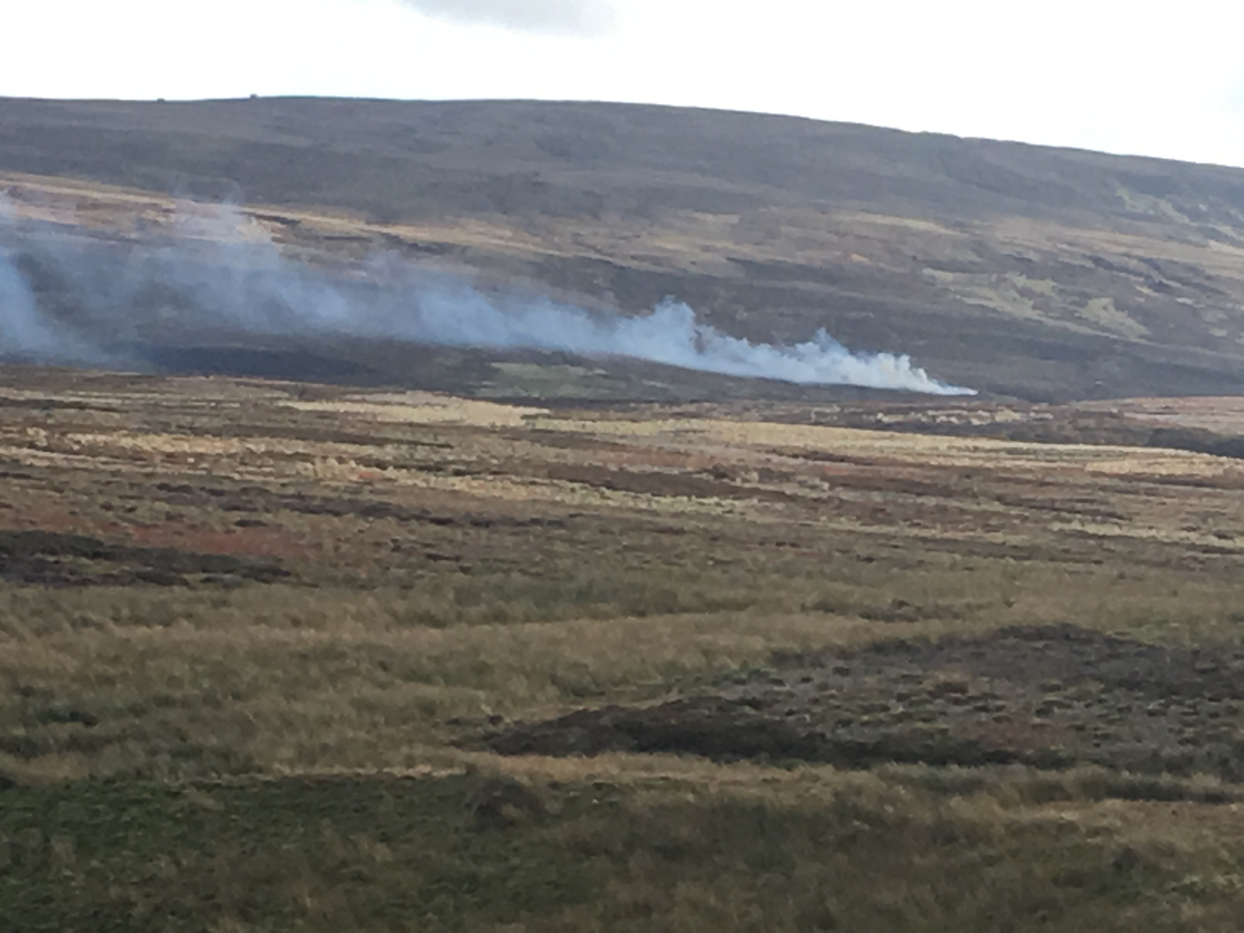
This was the example of moorland burning I saw on the northern edge of the Yorkshire Dales National Park three weeks ago. Does this comply with the voluntary agreement made by many grouse moors not to burn on blanket bogs?
There are a couple of things that I would need to know before I could be sure that this burning was (or was not) burning blanket bog. First I need to know where it is! And second I need to know whether it is on blanket bog. Neither is completely straight forward. And third it would be good to know whether the parcel of land concerned is part of an estate which has signed up to the voluntary agreement, although that is a subsidiary interest.
So, do I know where I was? Yes, up to a point (Lord Copper). I was on the road between Tan Hill and Reeth.
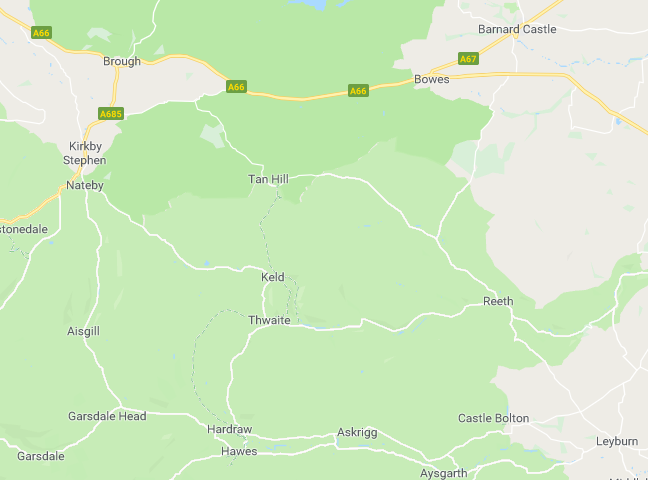
Screenshot of Google Maps
In fact I was on the road between Tan Hill and Whaw. But there isn’t much that Google Maps tells me about this place.
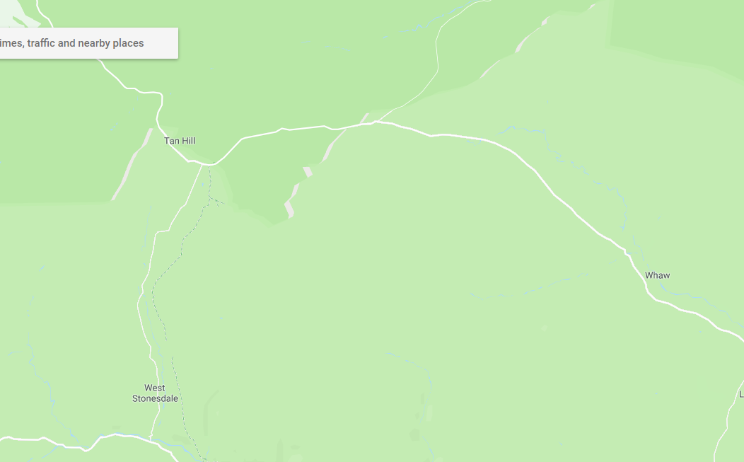
Screenshot from Google Maps
But when I click on the satellite image option in Google Maps I can see on the screen what I could see on the ground (more easily than in the photo above, but it’s pretty clear in that too) that there was a patchwork of different aged heather stands characteristic of grouse moors.
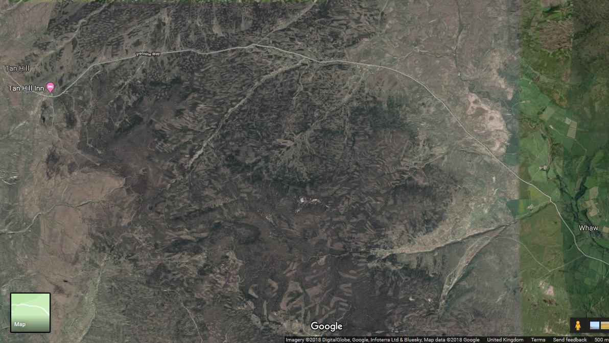
Screenshot from Google Maps
Not many landmarks out on the moor are there? Do I really remember exactly where I was? Well, I think I do, I was on the road, heading east, and looking south towards what I see online on an OS Map is called Water Crag.
Time to switch to the online MAGIC system. This system takes a little bit of practice to understand and master – I’ve had a bit of practice so I quickly got to the right place. Here is what I found.
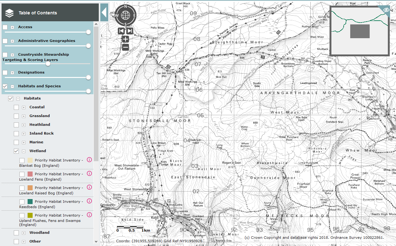
Screenshot from Defra MAGIC (the only time that Defra and Magic are used in the same phrase?)
So I was looking at the area where Stonesdale Moor and Arkengarthdale Moor join. And then, look at the left hand toolbar – what would happen if I tick that box for Priority Habitat Blanket Bog?
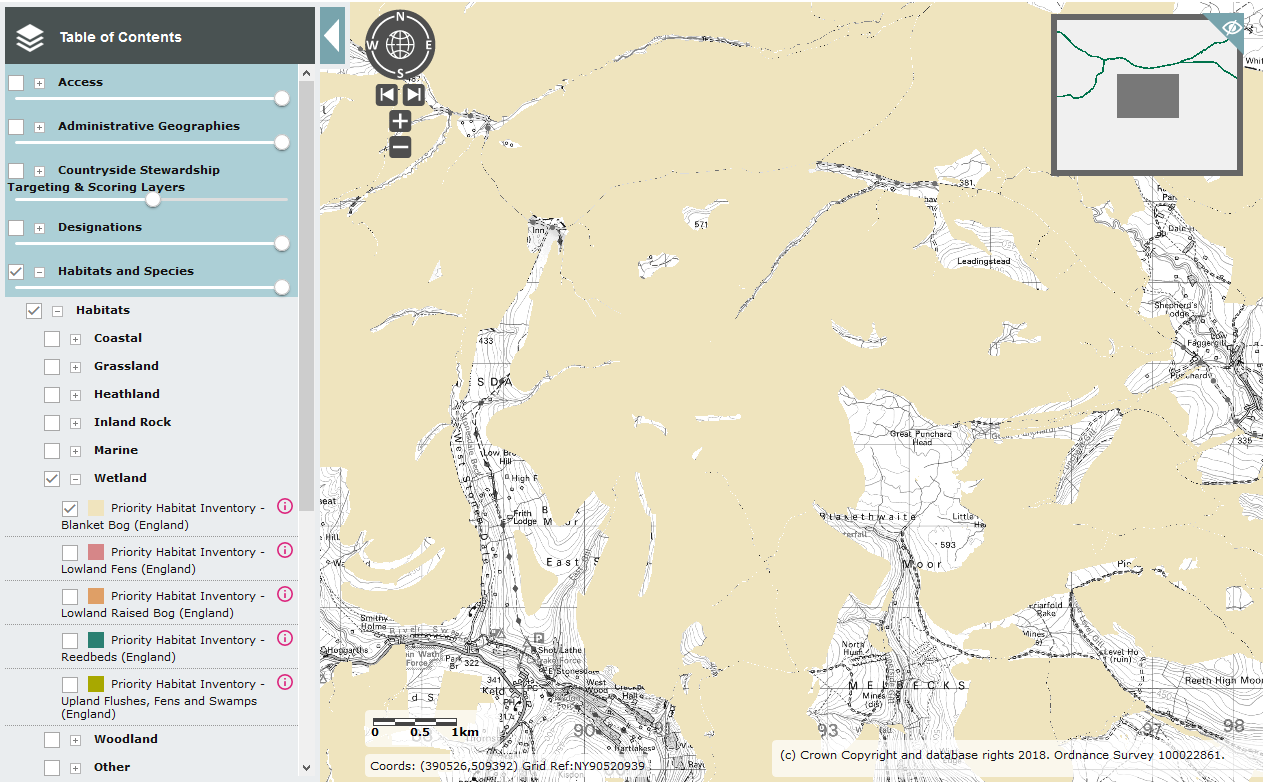
Screenshot from Defra MAGIC (the only time that Defra and Magic are used in the same phrase?)
Can you see that almost all of the map has shaded itself in that buff colour which means that it is blanket bog? There are two knolls which are not shaded as blanket bog but apart from the very narrow streamsides everything else is blanket bog. Phew – that was easier than it might have been! Almost everything on that side of the road is blanket bog so a bit of uncertainty over the exact location won’t matter too much.
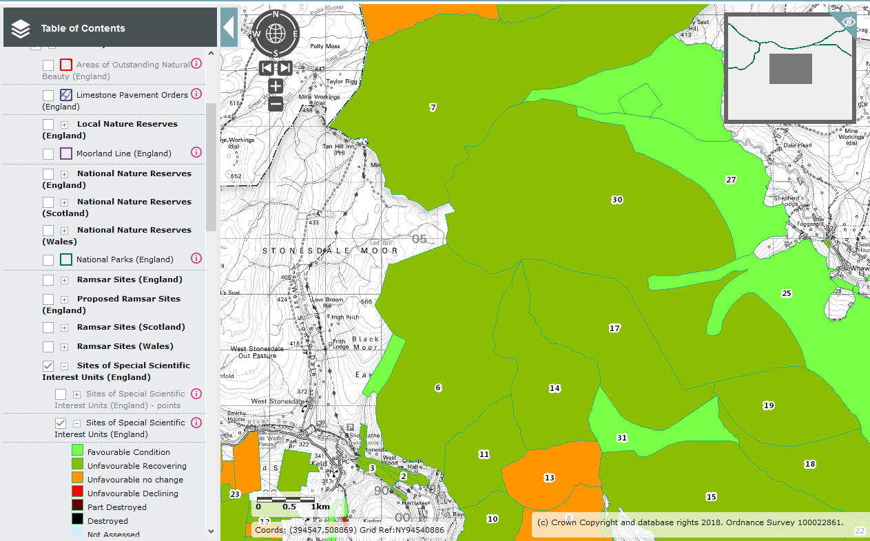
MAGIC will also tell me about the SSSI units involved – and to find out all I had to do was to click on the SSSI tools and ask for the SSSI units to be displayed, thus…
Screenshot from Defra MAGIC (the only time that Defra and Magic are used in the same phrase?)
That’s handy. I was looking at Unit 30 which is depicted as being in Unfavourable Condition (tut! tut!) but recovering (which might only mean that there is some sort of plan in place which might make things better eventually if followed strictly and completely).
I wonder which SSSI that is? Time to switch to a Natural England system for more information. The site is an SSSI, it is in North Yorkshire and it seems to be on Arkengarthdale Moor. So I use the search engine and strike lucky first time (well, it was skill really) as Arkengarthdale, Gunnerside and Reeth Moors SSSI appears in answer to my search., thus…
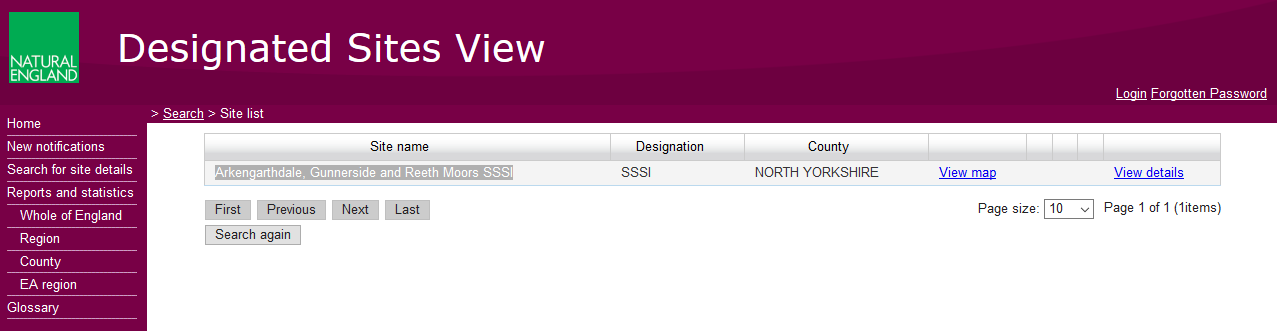
When I click on ‘View map’ it takes me back to MAGIC and shows me the whole SSSI, and reassuringly it is in the right place!
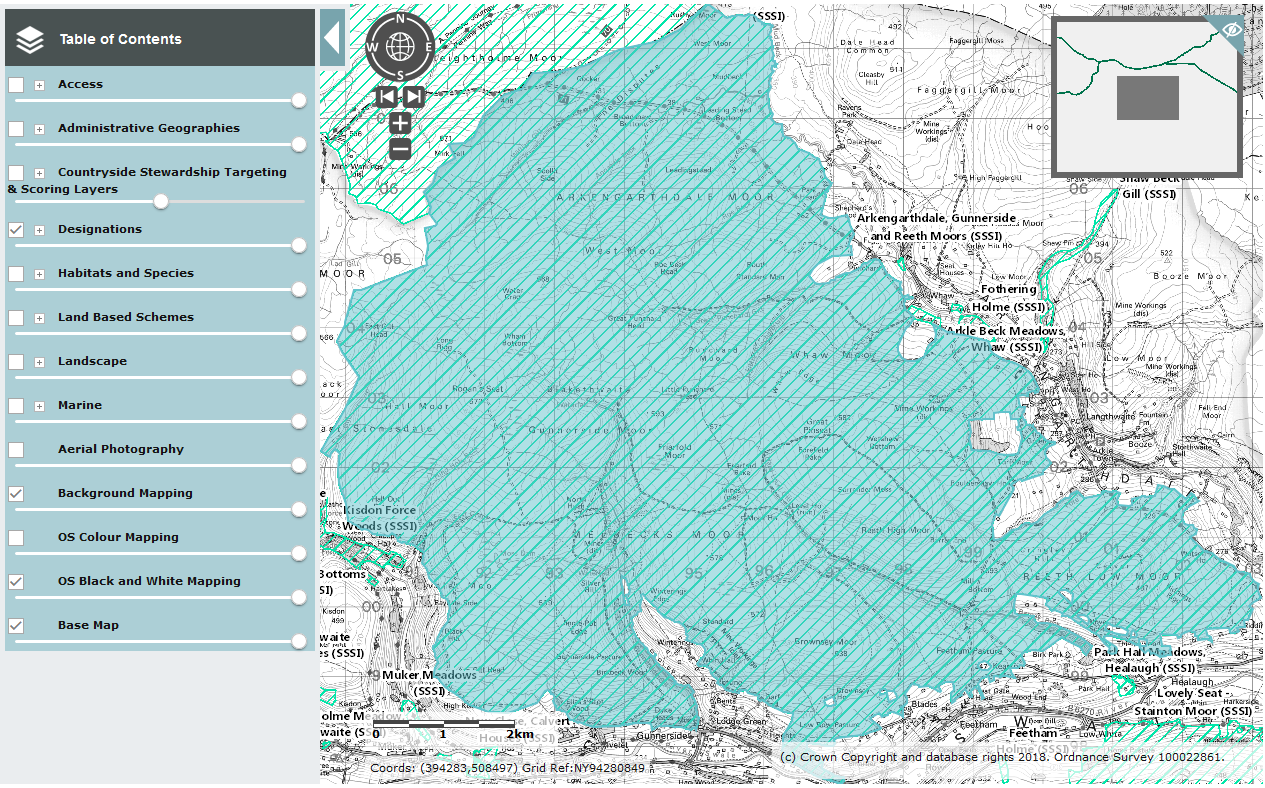
Screenshot from Defra MAGIC (the only time that Defra and Magic are used in the same phrase?)
And when I click ‘View details’ then lots of information becomes available. In particular this about blanket bog management (which is a standard paragraph used for many upland SSSIs):
Where heather burning is practiced, the burns should be carried out under conditions that encourage ‘cool’ burns which do not burn into the moss layer or peat. Burning blanket bog can reduce its conservation value where burns are too hot, too frequent or are carried out in the wrong place. Areas that contain pools should not be burnt, as it can be very damaging to the moss hummocks, invertebrate and amphibian populations that they support. Burning can also damage the top layer of peat and prevent the formation of new peat. Burning should not be introduced to blanket bog areas that have not been burnt. In areas where accidental fires are likely, firebreaks can be managed through very careful cutting or burning.No new drainage should be introduced to blanket bogs and deepen
https://designatedsites.naturalengland.org.uk/PDFsForWeb/VAM/2000333.pdf
ing of any existing surface drainage should be avoided. It will be appropriate to block existing drains that are eroding or are lowering the water table.
And then I can go and look at more detail what NE thinks of Unit 30.
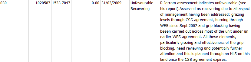
This tells us that unit 30 has an id number of 1020587, is 1533 ha (ie 15 square kilometres – it’s big), has zero overlap with an NNR and was last visited over 9 years ago (apparently). But R Jerram reports that it is (was!) recovering because grazing has been fixed, grips blocked and burning addressed. That’s good, although it would be more reassuring if the latest visit was much more recent. And the whole thing needs to be updated as a result of the voluntary agreements between landowners and Defra. Presumably the owners of this moor will be negotiating a replacement agreement with NE so that burning of blanket bog will become a thing of the distant past although there are so many loopholes in the agreement that it may not limit things very much.
According to the excellent website ‘Who Owns England’, Arkengarthdale and West Arkengarthdale Estates have signed up to the Defra agreement to cease burning blanket bog, and so they should since the owner of West Arkengarthdale Estate, the Duke of Norfolk, was present at that meeting with both Michael Gove and Therese Coffey on 1 February this year.
At the end of this lengthy post, what have we learned?
- it is possible, as a member of the public, to check whether some heather burning that you see as you walk or drive through the English uplands is complying with the wish of Defra (and the instruction of the EU) that we in the UK should cease damaging protected blanket bog habitat through burning it. It’s not completely straightforward but I hope that the information provided here will help you do something similar. If you are walking and have a GPS device (check your phone) then you will be able to pinpoint very exactly where you are standing. If you have an OS map to hand then it should be very easy to get a good fix on the area (and you can always hail a passing Boy Scout (of any gender) for help if needed).
- the fire I saw appeared to be on blanket bog and probably on an estate which has volunteered to eschew this type of thing. So, should I report this incident to Natural England? Well, I won’t be complaining to NE because this was a tiny fire and I didn’t get close enough to it to see exactly what was happening. It’s unlikely that someone was having a bonfire in the middle of a remote patch of blanket bog on the northern edge of the Yorkshire Dales National Park but I can’t rule that out completely. I didn’t see anybody, and certainly not a team of beaters by the fire so it is a bit of a puzzle to me. However, if this had been a ‘proper’ burn then it would seem to have been an ‘improper’ one so I would then have reported it to NE.
- I learned (I think re-learned actually) how easy it is to see the area of blanket bog mapped on MAGIC – I thought that aspect might be much more difficult to work out. And I’ve had a look at lots of other moorland areas on the map and that aspect of MAGIC looks like it will be a very handy aid to citizen policing of the voluntary agreements, and later binding agreements, not to burn blanket bogs. You can’t easily hide a fire on open moorland. There is great scope for you to help Natural England and Michael Gove to get this right.
This is excellent.
Surely it is possible for those who are as concerned about this as Mark, and who are also prepared to go on to the moors equipped with a smartphone and a walking pole with the disc on the base removed to measure depth, could record the location of each of several peat depths together with photographs of the burnt area, peat depth, and gps location, none of which require mobile phone signal. They could do the same as yourself at home and advise Defra of the finding and ask that the data be included.
Personally, I’d rather someone took over the latter part and ask for submissions from people who walk near such burnt moors, on open access land if in England. A protocol could be developed which could suggest a methodology for selecting suitable locations on moors to take readings, and the procedure to be adopted. The data could be included on a suitable system independently of Defra and the open access databases recently provided by the RSPB would be a good start.
All it needs a the setting up of the protocols by someone who is aware of the requirements and a website to collate the data. Still plenty time this burning season. Do you think there is any likely interest in this?
Excellent. I have bookmarked this blog post for future reference. I live between the Yorkshire Dales and North York Moors national parks and it always sickens me to see the wanton and pointless destruction of habitat that heather burning entails. It’s not even good for the grouse! I’m hoping that I’ll see a great deal less of it this coming winter but will certainly check out any that I do see and log it with Defra as appropriate.
There’s a simple and free phone app called WhereAmIAt (sic) that will give you your precise location.
Really good article Mark, very informative.
Amazing how much work is required to find this stuff out. Despite being subsidised by us.
Thanks to being subsidised by us not much work is required.
Go to the Magic site, find your place of interest, mark it using the Site Check tools
In the ToC expand and tick everything you want to know about at the site, conversely make sure anything you don’t want to know is unticked, because you will get otherwise reams of stuff you didn’t want to know.
Use the Perform Site Check tool.
Print a pdf of the output.
Excellent, I would have reported it Mark. Most fires these days are relatively small as management has intensified size of fire has reduced but the number vastly increased. They are often cut round with a flail mower attached to a small 4 wheel drive tractor and usually attended by one person, often plus the tractor driver, who is usually in my experience the head keeper. Most burning these days takes place in spring, which I’ve never understood because autumn burnt starts to green up the following spring, spring burning doesn’t usually start to green up until the following spring except for areas of bracken ( burning code says these should be avoided) but they rarely are. This leads to increases in bracken cover and the eventual need to use Azulam to control it.
Just my opinion but I believe that burning in spring, as late as possible, is done to deter hen harriers from nesting. Otherwise the keepers will have to shoot/trap/poison them with the risk of getting caught. But it also deters lapwing, curlew and golden plover, three species that the shooting lobby like to bang on about benefiting from grouse moor management.
I see someone here doesn’t like the idea of grouse moors be held to the minimal standards that, in this case at least, they have signed up to. Why on earth not? Or do the dissenters here just routinely click on ‘Dislike’ without either reading or understanding the posts?
Not the easiest of websites to navigate until you get the hang of it.
It does hold a lot of interesting information
For example the area you are looking at seems to be under HLS and ELS which are usually 10 year agreements. The customer will almost certainly also received Basic Farm Subsides at approx £56 ha which adds up to close to £200,000 PA.
Someone or some people are and have been getting an awful lot of taxpayers money (unless my maths is incorrect it averages out at around £500,000 a year at current rates) for what might be deemed mismanagement of that moor.
Reference: AG00315411
Scheme: Entry Level plus Higher Level Stewardship
Customer Name: Arkengarthdale West Graziers
Town: York
Start Date:01/11/2010
Total Cost of Agreement (£)3370090.35
Amount Paid to Date (£)2629784.45
Total Area Under Agreement (ha)3510.54