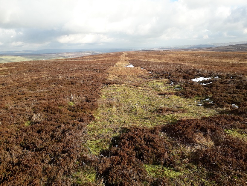
Here are some images of the proposed path of the track across Walshaw Moor: all taken at the weekend by the wonderful Bob Berzins.
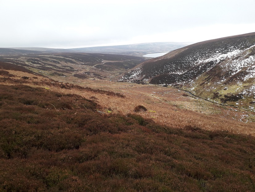
Bob tells me ‘It is all deep peat up there and has a great wilderness feel. There is very little sign of vehicles being used so far. It would be an absolute desecration to build this road.‘.
There are four parts of the proposed track.
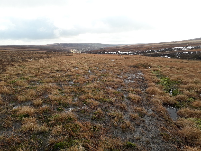
The southern spur makes its way north up the Walshaw Dean valley.
The route of the track is already apparently marked with white plastic marker posts in some places.
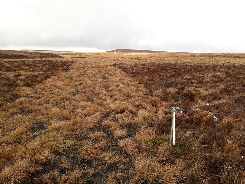
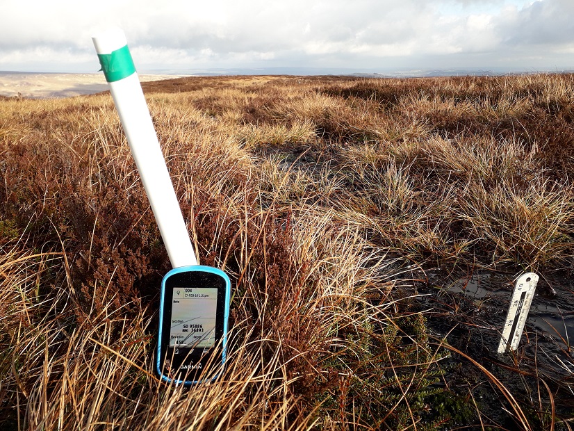
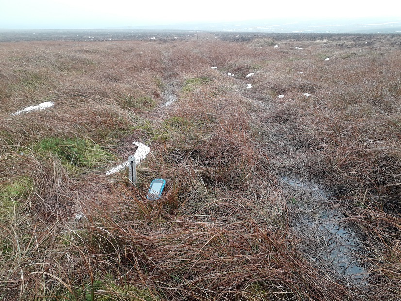
Here are some helpful measurements of peat depth next to two of those marker posts in this, rather dry-looking, part of the track.
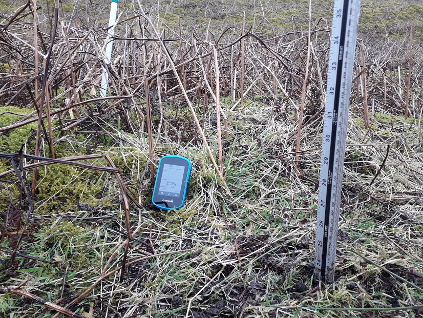
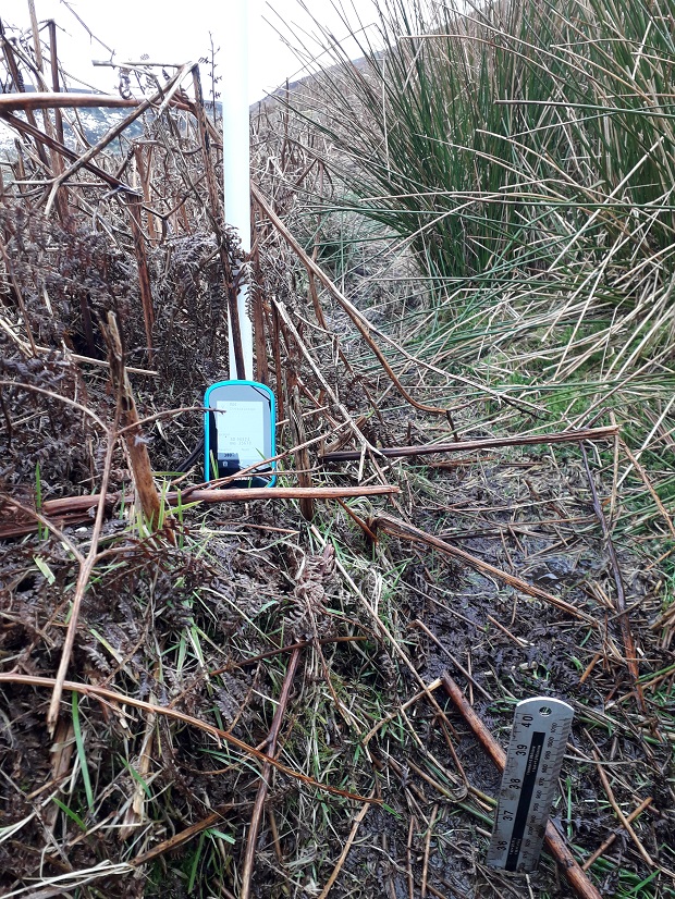
Not so dry after all then! Deep peat.
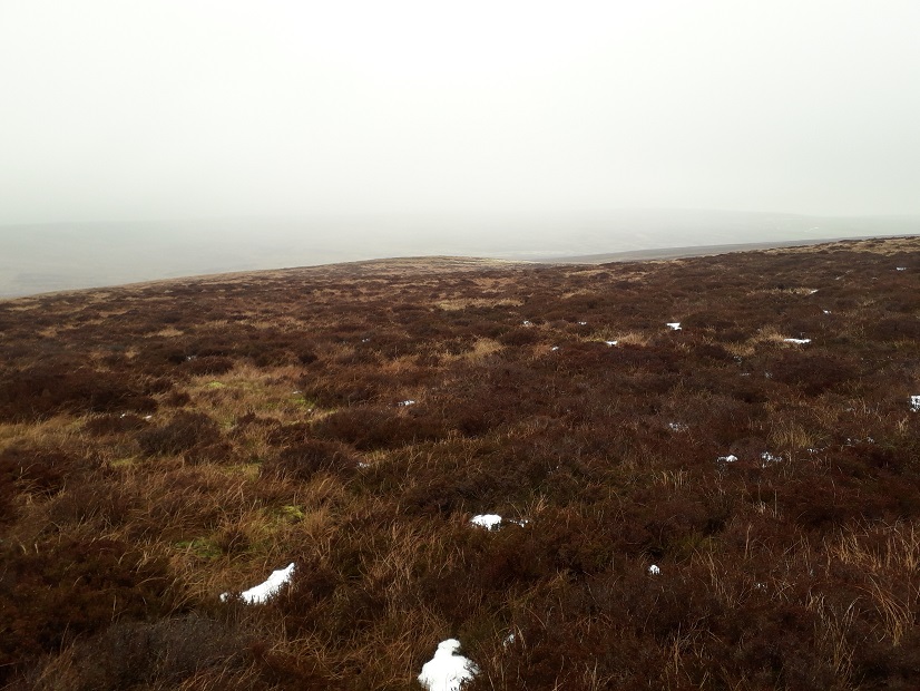
The next section is that which crosses active blanket bog and is largely in Calderdale Council area (c600m) but partly in Pendle (c100m). This is where a timber rafted track is planned. As you might expect, this area is distinctly soggy. Have a look:
The northern spur then continues over this land:
The eastern spur:
Bob tells me that his measurements consistently give much deeper peat depths than those reported in the Catchment Restoration Plan signed off by Natural England. Maybe he is wrong – but I do wonder whether it would be a valuable exercise for Natural England to check these measurements and for Pendle and Calderdale Councils to be aware of them too. Maybe the estate were measuring in inches not centimetres? Has NE checked these measurements which form part of their agreement with the estate? If not, why not? Will NE check them now – and by now I mean in the next few days? If NE can’t manage to check these measurements then maybe we all ought to have a day out with rulers on Walshaw Moor some time soon to help them out?
Bob’s measurements will find their way to the relevant planning authorities, of that I’m sure.
 As Bob says, this is a pretty wild place – why has NE signed up to a plan whose origin was to stop rotational burning on blanket bogs (which has so many loopholes that it is arguably useless) and which instead of protecting blanket bogs drives a 5km track through those blanket bogs in one of the wildest parts of northern England? This is entirely shocking.
How deep has NE sunk? Up to its neck in peat – and it’s not waving but drowning.
We wouldn’t be looking at this industrialisation of our uplands if it weren’t for the ‘sport’ of driven grouse shooting. Let’s get our politicians to end this damage – please sign Gavin Gamble’s e-petition in favour of banning driven grouse shooting.
[registration_form]
Great work Bob!
Natural England? Not so much.
Shocking.
All good stuff, but I will make the same point again – apologies if this is getting tedious.
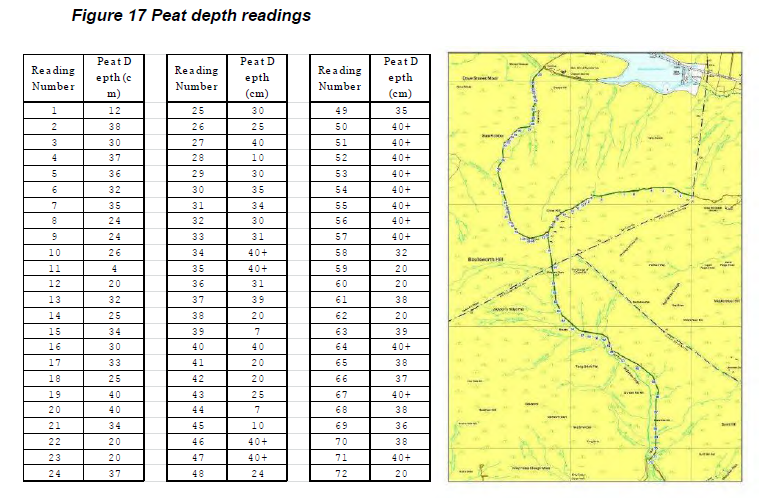
Blanket bog is defined as occurring on peat of a depth greater than 50cm. If the peat depth is less than 50cm it’s defined as upland heath. A peat depth of 40+cm in this case tells us nothing about whether the area is upland heath or blanket bog.
Miles – thanks – you’ll see that the measurements referred to are all out of any area of doubt.
You know more about this than I, but ‘There is no single formal definition of ‘peat’ and ‘peatland’, differing interest groups
having differing definitions. Thus ecologists use a minimum peat depth of 30 cm while geological surveys may use 1 m as the threshold. The Soil Survey of Scotland uses a minimum depth of 40cm for pure-peat soils, whereas the limit for the Soil Survey for
England and Wales ranges from 30 cm to 50 cm.’ from IUCN UK Committee briefing note 2014 http://www.iucn-uk-peatlandprogramme.org/sites/www.iucn-uk-peatlandprogramme.org/files/1-10%20Peatland%20Briefings%20-%205th%20November%202014.pdf
And ‘Peat depth is also very variable, with an average of 0.5–3m being fairly typical but depths in excess of 5m not unusual. There is no agreed minimum depth of peat which can support blanket bog vegetation. It includes the EC Habitats Directive priority habitat ‘active’ blanket bog, the definition of active being given as ‘still supporting a significant area of vegetation that is normally peat forming’.’ from jncc.defra.gov.uk/Docs/UKBAP_BAPHabitats-03-BlanketBog.doc
Irrespective of the definitions, Bob Berzins’ measurements indicate substantially greater peat depths than those shown in ‘Figure 17’. Any decision on this track should not be based on misleading or inaccurate data.
thanks Mark.
I was only referring to the arbitrary, but agreed, distinction between upland heath priority habitat and blanket bog priority habitat, which is 50cm peat depth. It would be pretty unusual to find blanket bog vegetation on peat depths of less than 50cm – but I’m sure it’s possible. As with everything else in nature, habitats don’t read the books.
If you wanted to be more certain about whether you were standing on blanket bog, upland heath, or some other upland community, you’d need to collect some vegetation data (quadrats), as well as measure the peat depth. This is especially true if you’re trying to decide whether a blanket bog is active or not, for the purposes of allocating areas according to Habitats Directive habitats.
Thank you Bob,it will be an absolute traversty if this track gets the go ahead,and will have grave consequences for lots of our Uplands,it beggars belief that Natural England can agree to this fiasco,on these Uplands which has some of the most protected of habitats in the U K, it shows quite firmly who is calling the shots here, make no mistake about it.This has to be stopped now before there is absolutely no Wild places left .
The question remains, have Natural England measured the peat depths? If not why not? If not then who signed that decision off? It’s not a witch hunt but quite simply it is looking increasingly like more evidence that Natural England aren’t fit for purpose? Is this acceptable Mr Gove?
Standardisation of methods is helpful for comparisons – a soil probe similar to that used by soil scientists would be good for a start. They can be made quite easily by agricultural engineers.
And even wet heath vegetation on peat >50 cm is bog, though technically degraded bog. And in wales we often have bog vegetation on shallow peat so not heath either. Tracks or roads across areas of deep peat are really bad at intercepting diffuse water movement through the surface layers of peat and will dry out up to 250 m downslope of it depending on the conductivity of the peat. So the effects are not confined to next to the track