Michael Joseph lives and works in the Peak District. He moved there in 2014 from London and enjoys cycling and running in the area. He has been involved in several projects over the years including the Bradwell Hydro Project and the Hope Valley Air Quality project, both of which were funded by the Peak District National Park Authority. He is also a member of Hope Valley Climate Action.
Mike says: I am not an air quality scientist or a data scientist so I can only offer a few general observations on the apparent link between the burning that I saw on the moors and the air quality measurements taken locally at the same time.
On March 5 of this year I was out for an afternoon walk and went up Win Hill reaching the summit at about 14:30.
Once at the top I noticed that there was a large cloud of smoke from a moorland burn visible on Shatton edge to the left of the radio mast. I took a photo of this burn, see below. The burn was very noticeable from my viewpoint and the wind appeared to be taking the smoke westwards towards Bradwell.
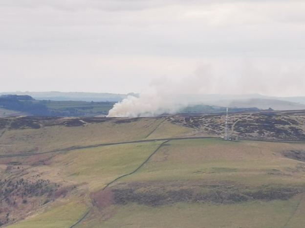
Shatton Edge burn plume, March 5, 2021 – 14:30
In the opposite direction of view and at the same time I noticed a pall of smoke over the Moor immediately to the right of the Ladybower reservoir, see below.
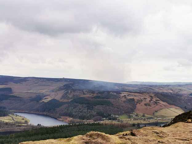
Ladybower reservoir showing burn plume on March 5, 2021 – 14:30
The result of this second burn was quite striking as within the short period of time I was watching the smoke drifted across the Snake road and descended to fill the Hope valley around Hope village with a white haze. You could clearly see this, Hope had become clouded and foggy-looking from Win Hill.
Early last year the Hope Valley Climate Action group and the Peak Park worked on a joint project to deploy a network of Air Quality sensors operating in the Hope valley. These sensors (12 in all) record PM2. 5 (particulates up to 2.5 microns) and PM10 (particulates up to 10 microns). These PM readings are widely used as an indicator of air quality and prolonged exposure to elevated levels of these particulates has been consistently linked to poor health and reduced lifespan.
The data from these sensors is available to anyone who is interested. Both Hope and Castleton have AQ sensors as do Edale, Bradwell, Bamford, Hathersage and Grindleford.
A subsequent review of the air quality sensor readings for March 5 provide some insights into the direct impact of this burn on the air quality in the upper Hope Valley locations.
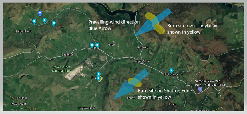
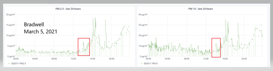
Initially I checked the data for Bradwell as the Shatton Edge fire smoke plume appeared to be sending smoke generally in the direction of Bradwell Dale and the upper end of that Parish. And indeed there is a correlation at around 14:30 with the air quality readings for Bradwell on that day. You can see this in the image below, Chart 1.
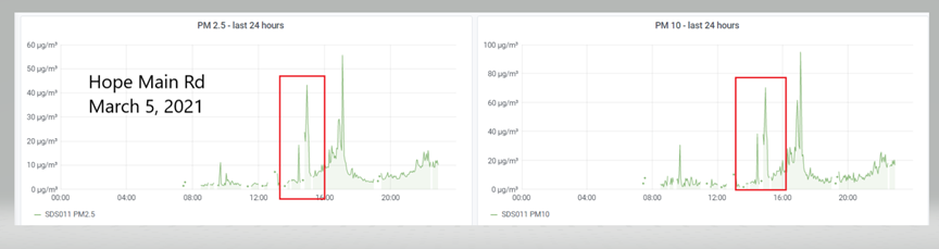
However the burn on Ladybower had far more impact on the sensor readings and most affected was the village of Hope with the AQ readings on the main road in Hope showing very high counts of particulates around 14:30 on that day. You can see this in Chart 2 below. The surge to a high of almost 40ug/m3 of PM2. 5 and almost 80 of PM10 is very striking and it would certainly represent a level of air pollution very abnormal for the Hope Valley.
Often sensor data shows a rise in the PM counts when fog is present or when there is smoke from log burners and coal fires accumulating, though this tends to be blown away fairly quickly. However neither of these two possible causes of high readings appear to be the reason for the high counts we see for this time of the day on March 5 as there was no fog as is evidenced by the photos and it is the wrong time of the day for log burners or coal fires. Indeed it was a mild day and one unlikely to prompt a home fire be lit.
There is therefore a strong likelihood that the surge in particulates, especially in Hope Village from 14:30 onwards on March 5 was directly attributable to the fire burning on the moor above the Ladybower reservoir that day.
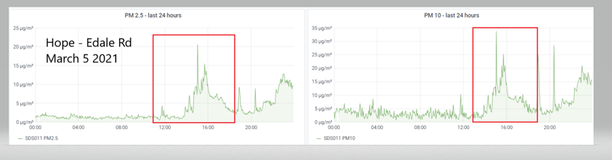
I have highlighted the spike at 14:00 on the charts to show the very clear correlation with the burning that was photographed at that time. However the data suggests the impact carried on for many hours after 14:00 and this is clear in the charts which show a much higher spike later on.
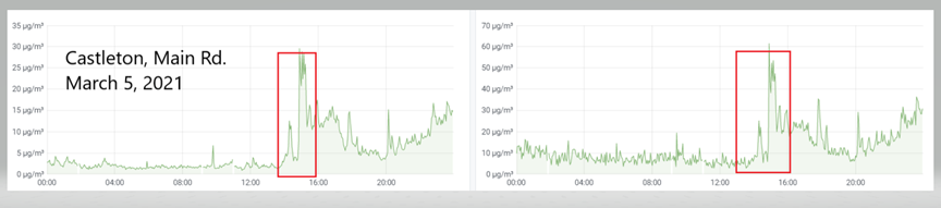
In Castleton, Chart 4, in terms of the count but the same pattern appears with a long tail of readings well before evening wood burner time.
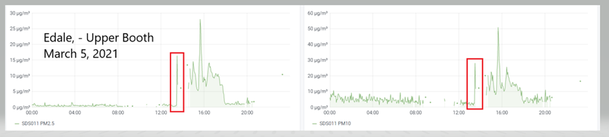
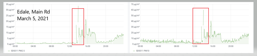
In the readings for Edale (Charts 5 and 6, below) a spike shows up even here at the far end of the valley and there is another long tail of readings long before wood burner time.
As a control I have listed Bamford (Chart 7), largely because it is to the side of both fires but should show roughly the same pattern of weather and wood burner related readings.
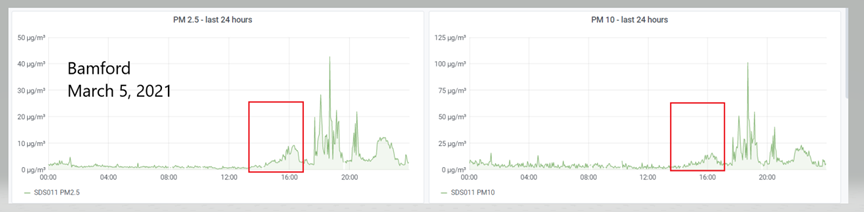
As you can see there is a minor effect at around the same time and this is what would be expected given the off site location of the sensors. It is interesting that there is an impact, however minor, on a site which is well out of the general direction of the wind.
On this particular day the data indicates that for many hours the residents of the upper Hope Valley, most especially Hope Village and Castleton village were subject to abnormally high levels of particulate pollution unlike anything normally experienced in the area. The photographic evidence of the burning at that time, the direction of the wind and my own observations of the smoke plume settling in the Hope Valley very strongly suggest that this reduction in air quality can be directly attributed to the burning on the moor above the Ladybower reservoir.
[registration_form]
This is good science, well done. It all helps to work towards a total ban on Driven Grouse Shooting and all its associated damaging practices like this.
Funny that that Government has now prohibited the burning of wet wood on wood burning stoves but not the burning of grouse moors. What a double dealing, deceitful and disgraceful lot Defra and this Westminster Government are.
I found this really interesting and I feel like someone should be collating more data to back up such observations.
Ironically there’s an article out about air quality as a result of a wildfire in the Peaks but those championing that article didn’t make the connection with their own moorland burning.
Perhaps we should be approaching DEFRA and asking what they are going to do about this.