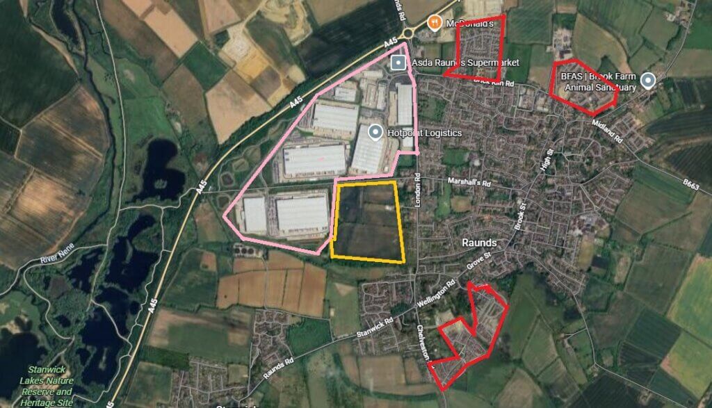
This is an image of Raunds; the rural town where I have lived for half my life.
In passing, you can see Stanwick Lakes, my local birdwatching patch, to the west of the A45, at the left hand side of the image. And the B663 is the road by which I left home to head towards The Lodge, Sandy, Beds while I worked at the RSPB.
The population now is over 10,000 and rising compared (10,233 in 2021 census) with 20+ years ago when it was 8,380 (1991 census) – click here. That’s a 22% increase in 20 years, compared with the national (English) overall population change of c16%.
Some of that change has been through brownfield development – old shoe works and the RPC Containers factory – but most recently the rise has been on greenfield sites (shown in red on the map).
Through the same period, the area outlined in pink, Warth Park (as in industrial park) has been built. I cannot look at that area without thinking ‘Why aren’t there solar panels on all that roof space? And why wasn’t that a condition of planning approval?’.
The pink and red areas are bigger than the footprint of the rest of Raunds, ie the town has doubled in size in 20 years due to housing and warehouses, and is still growing.
The yellow boundary shows an area that is expected to seek planning approval for 400+ houses and which hasn’t gone down too well with some locals. The points made in this – click here -1500-signature petition are all good ones, although I smile, ruefully, to see that wildlife is dragged into public debate mostly when it can be used to fight development.
There is no planning proposal but the developers are already working hard to soften up local opinion. The concerns about traffic are well made – anyone travelling in this area knows how often one is sitting still in traffic. So too are the flooding and strain on facilities points. I’ll be interested to see what sorts of houses are planned. I’d be amazed if there is much in the way of social housing.
But developers feel they have been given a green light by our government to make money from concrete pouring anywhere. They must feel that they are sailing their treasure galleons in a fair wind. We have a unitary authority which is Reform – the populist move would be to turn down this development. We’ll see.
[registration_form]
Growth growth growth – for the economy and the human population. One giant ponzi scheme for a totally overcrowded country that is unable to feed itself, yet more of the same Thatcherite nonsense from a Labour Govt that is a disgrace to the name of labour. Nature is being overwhelmed by human beings. I despair, especially for what is left of rural England. And I fled north to the Scottish Highlands to escape the worst of it.
Until I retired 8 years ago I worked for Anglian Water. Raunds sewage works was one of the sites I used to visit on a regular basis. Although it functioned perfectly it was at it’s limit regarding how much flow it could cope with. As far as I am aware no work to improve the site has been done and yet Raunds keeps expanding. And any work they does get done eventually will be paid for by the customers.
Presumably if there has been no upgrade to the ETP and it was working at full capacity before some of the development described, it must now be breaching its consent limits on a frequent basis. I guess the wildlife in the River Nene is paying for that. It beggars belief that housing can be built without first ensuring the sewage infrastructure is adequate to cope with the extra load.
You are doubly cursed in north Northamptonshire in that successive governments have identified it as a “growth area” (i.e. an area for accelerated, low-density, car-dependent housing sprawl) and by the haulage industry as the centre of England’s logisitics corridor (i.e. massive, truck-dependent, distribution warehouses). Both are fundamental reasons why this country is developing unsustainably.
Normally we ought to be campaigning to reopen some of the area’s extensive network of closed lines, especially given the growth of Rushden/Higham Ferrers/Irthlingborough/Raunds. Most old rail alignments in that locale have, however, already been built over, apart from the old Northampton-Peterborough route, parts of which are still intact (though it did go through Stanwick Lakes).
But just recently, the government has published plans to allow a virtual free-for-all for house building near any railway station, including those in the countryside or even green belts. But then as they’re also slowly dismantling the reset of the planning and environmenal regulatory systems, perhaps that shouldn’t be a disincentive to rai reopening.