The flooding in south Yorkshire has been in the news a lot. As others have pointed out, the flooding of a place called Fishlake is written in its name.
I’m interested in the contribution made by grouse moor management, both burning and drainage, to flooding but I don’t know much about the Don. Fishlake is a long way from any grouse moors, and I’m not an expert. So I was interested to see Professor Ian Rotherham, who is local, and is a bit of an expert quoted in this BBC piece as saying this (amongst other things);
This water is coming from the uplands, it is coming from the Peak District, from the Pennines, and what we have had there is the massive removal of peat by cutting, the burning of heather moorland and of course drainage, and instead of holding the water back in the uplands, it shoots downstream.
All the way along we have straightened the rivers and drained the flood lands. The water rushes down. It is not being held back and it spews out across the lowlands and that’s what happened here.
https://www.bbc.co.uk/news/science-environment-50393617
Now there is good science that supports this general contention and has been for many years. I can’t comment on the likelihood of this being what’s happening in this particular case but it certainly seems possible. And the flooding seems to be a very localised thing – for example Walshaw Moor is not very far from the northern edge of the Peak District and yet I’ve seen no reports of flooding there, though I’m sure it must have rained (though maybe nowhere near as much?).
What is possible is to look at some of the headwaters of the Don and look at land use up there in the Peak District, miles and miles from Fishlake and other affected places.
This wikipedia page tells us quite a lot about the Don catchment and you’ll notice that there are several reservoirs eg Snailsden, Midhope, Langsett etc) which feed the river. What is the land use around those upland reservoirs I wonder?
Here are Langsett and Midhope reservoirs;
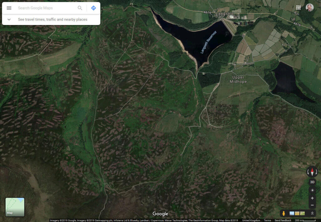
…and they clearly are situated in an area of intensive heather burning.
Here are Winscar, Harden and Snailsden reservoirs…

…also right next to some grouse moors.
And Broomhead Reservoir…
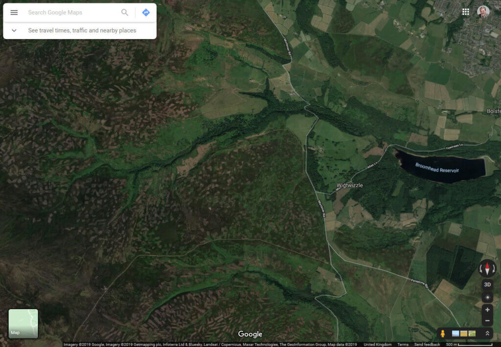
…that gets its water from a large upland area of grouse moor too.
Of course, there are other bits of the catchment that are nowhere near grouse moors, but quite a lot of the upper catchment has grouse shooting neighbours. And you can see from the satellite images that these areas have been intensively burned in recent years, and some say that the threat of removal of permission to burn blanket bog has provided an incentive to get more burning done in recent years.
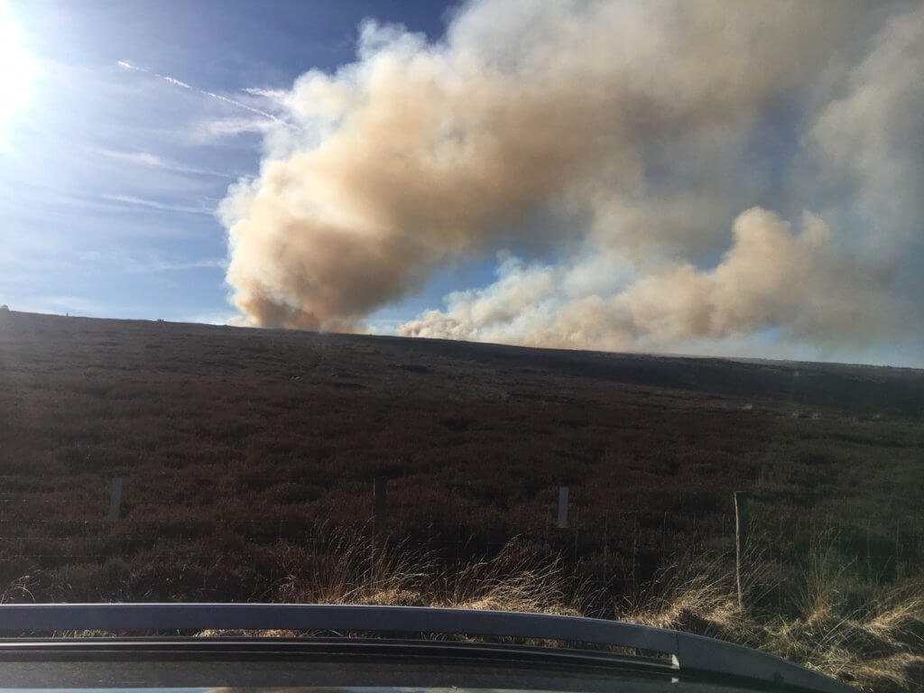
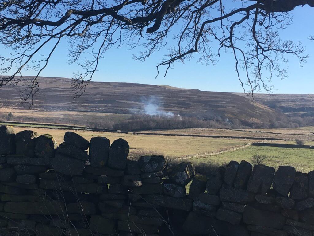
Certainly parts of this catchment have been burned recently – here are two images published on this blog in February in this very area when I was simply driving through (on my way to Preston to give a talk) one day:
Now Fishlake isn’t the only place to be flooded and it is miles from the Peak District, about 30 miles as the Don flows according to my calculation, and it is right next to the Humberhead Levels and Thorne and Hatfield Moors so it is in an area which used to be a large wetland, but water flows down hill and gathers more and more water as it flows. It’s not a new idea that we should be looking at the land use in upland areas to reduce flooding in lowland areas. It’s not a new idea, it’s just that governments rarely seem to get around to doing anything about it.
[registration_form]
It all sounds frighteningly obvious… So why haven’t the Government, Natural England, been aware of all this and got around to doing something about it… Where are the reports and recommendations from Scientists and Experts that one would have expected at every stage of building, burning, straightening, tree removal, etc ? Why were adequate procedures to safeguard never put in place…. wilful neglect? Seems it’s only now when Climate Crisis is starting to be an ‘OK’ subject that the Government might feel forced to address some major problems… Utter shame on them for burying their heads for so long. Hope people think about these things when voting.
Those photographs of the burnt Uplands are indeed a consideration for water catchment and the speed of the flow from our Moors. Many have been fighting for this issue to be addressed for years and it is increasingly being cited as a big part of the problem .Wake up D.E.F.R.A ,you have allowed so much burning of Sphagnum and Blanket Bog for years ,it is scandalous.
This time around, the area beneath Walshaw Moor escaped the fate of those around the River Don purely because we did not receive anywhere near as much rainfall on this occasion.
Only half an inch of rain at Hebden Bridge compared to several inches on the upper Don.
I’m always surprised that nobody in York makes the connection between the flooding the city ‘tolerates’ so stoically and the moorland practices in the catchment areas of the Ure and Swale
Maybe because the river has flooded for a few hundred years long before moorland management there are flood marks in the old pubs back to the 1800s
Bet grouse moors have made the flooding worse though and more trees and eventually beaver on them instead would make a difference https://www.gov.uk/government/news/beavers-arrive-in-essex-to-play-their-part-in-flood-prevention
Notable Don floods happened in 1536 and 1864 (a dam collapse).
This from someone at FLAG: “I grew up in the fifties in the part of Yorkshire that is now under water. In those days part of Plain of York was under water every year. Farmers moved their livestock on to higher ground and never planted winter crops. Villages and towns had grown up over centuries on slightly higher mounds. The land that flooded most was always–as today–just upstream from a confluence of one or more of the four main rivers that joined the Ouse – because the Ouse was often so full the joining river couldn’t empty into it. They are all pretty big rivers draining all the Pennines and the Moors so the floods were big. In those days it was all just part of a normal winter. And it was great when it all froze which it often did up to 1959.
In the early sixties the bends in the rivers were ironed out and the dykes raised so that the whole Vale drained much faster. The Ings that had flooded since Roman times did so no more (although some, like Fairburn on the Aire confluence, were turned into permanent wetlands). Inevitably then the developers moved in and villages expanded onto former water meadows nearby. The [authorities] could not but give permission. But the older people were gobsmacked.
Areas here and there, particularly a wetland called Thorne Waste were set aside to take excess water. They called them ‘nature reserves’ rather than flood protection areas. But for some of us it was only a matter of time. A new estate in a village called Barlby, near the confluence of the Wharfe and Ouse flooded when it was only a year or so old. Look at the TV photos of Fishlake. The church is dry. The old pub is dry. All the houses in the centre are dry. They are on the higher land. All the flooded houses are new; they are in the surrounding water meadows.
This land is 5m or less above sea level and the rivers have to flow above the land level if they are to empty. And so, as on the Levels, once the water has come out it can’t naturally get back. This happens most usually where three conditions are satisfied, previously wet soil, a heavy storm (7.9 mm which is not that big except by local standards) and a spring tide (as now) when the backup along rivers is strongest. I’m puzzled why, when we have known about this and lived with it for 2000 years, it takes us by surprise.”
Why in so many cases indeed. Why did/do Government ‘encourage’ 20% new housing to be built in flood plains? If this is still a Govt. policy then local planning authorities are unlikely to refuse permission as being taken to appeal is expensive and they will not want to waste funds etc.
Can anyone provide a definitive answer to the question, is it still policy that 20% of new housing to be built in flood plains? If so, is there a link to a Govt. website?
Of Fishlake, with St Cuthbert’s being built on slightly higher ground (they knew what they were doing in those days) it has (thus far) escaped the flood waters, ‘new’ bungalows on the other hand ….
I wonder if the Government’s advisers have subsequently reviewed this advice?
https://www.theguardian.com/environment/2016/jan/27/homes-and-companies-should-be-built-on-flood-plains-despite-risks-says-panel
Perhaps these advisers should take part in any enquiry which might be convened following the non-national emergency?
Despite all this, most of the stuff I hear the PM being quoted as saying is still ‘higher flood defences’ rather than reducing runoff.
And the overarching issue of why we’ve needed more and more houses for the last hundred or more years (population maybe?) still isn’t addressed by most people or the government. Child benefit anyone?
Filbert is spot on. It is extraordinary that the massive drainage campaign of the 50s – 70s has drifted out of people’s perceptions – running to billions of pounds in todays money it has allowed arable farming on land that, as Filbert rightly points out would have flooded annually, and from which farmers simply removed their stock in winter. Much of our flood defences in river flood plains have actually been built to stop the water getting onto the land – and thus, along with under field drainage, rushing it into peoples houses.
The other big factor – going way back – is that Europe has lost over 90% of its riverine woodland. Whilst grassland stores water trees, through friction, actually slow the flow. Whilst the uplands are vital to overall water quantities it is the lower, middle reaches that are probably more important in affecting peak flow, which is where the flooding is.
tbf I quoted a chap who commented on Flooding on the Levels Action Group FB pages. afaik the Somerset Levels have not flooded this year and I don’t know whether this is weatherly happenstance or because the dredging work carried out on the high level carriers has fixed the problem. It’s not dissimilar to the Don & Humberhead Levels – a look at the map shows a landscape without contour lines and squillions of embanked waterways and sea walls. Once waterways are engineered and embanked they need dredging and pumping will be needed to transfer water from low to high level. You can’t have people throwing the pumps in the bin, whatever happens upstream.