I’ve read this document – click here – several times, and I’ll need to read it several times more to get the most out of it. But my initial rating of it is 6.5/10 which is quite a bit higher than I expected.
I’d be very interested in others’ views on this document and I’d welcome them as comments on this blog post, and as guest blogs, on the Framework as a whole or on particular items contained therein.
We live in a crowded country with no remaining wilderness, declining wildlife, increased impacts of climate change on flooding and coastal erosion, some of the most intensive agriculture in the world and relatively low tree cover. The government wants more houses to be built to boost the economy (and maybe people will live in them too) and our transport infrastructure is somewhat Victorian which was good 150 years ago but not so impressive now.
The message from this first go at a Land Use Framework (an update is promised in five years) is that we have many of the right notes but not in the right places (to nod to Eric Morecambe). The unspoken elephant in the framework is that this is a result of individual choices by thousands of landowners who are all, understandably, working in ways that suit them and their families rather than society as a whole. We have solar farms spread over prime agricultural land because it suits the land owner more than wheat production, and we have quite a lot of land uses because they are traditional and some farmers are a conservative bunch (with a small ‘c’, although strangely attracted to Reform without a small ‘r’ it seems). Quite how we get many more people to do sensible things is not really spelled out here. I have an idea, but I’ll come back to that.
There are some useful diagrams and some useless ones. Here are three diagrams, you choose which is the useless one:
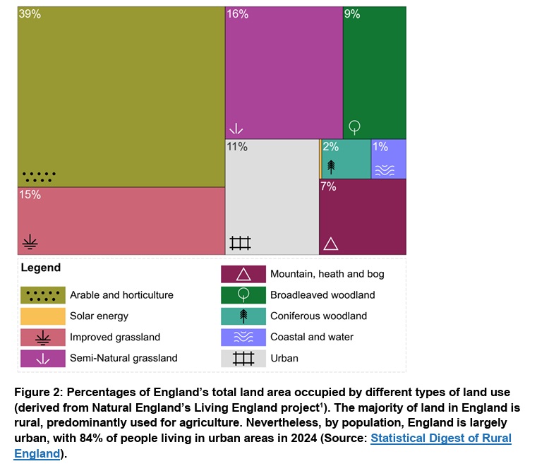
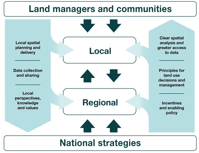
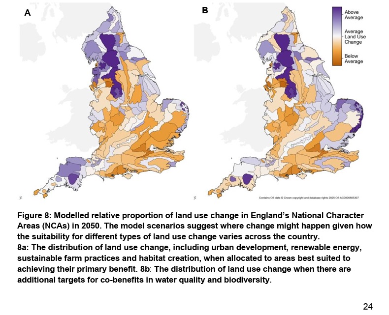
The top diagram has useful information about how much of broad land use types exists now (I’ll try to remember those figures); the middle diagram just reminds me of lots of pointing fingers with the caption ‘I thought they were going to do it, not me’; and the third, the pair of maps is very interesting, being two ways of looking at where most change is needed (the darker, bluer areas).
To get things better, most change is needed in the uplands which means in rough grassland and peatland areas (and some pointlessly improved grassland areas). That seems right to me for all the reasons rehearsed on this blog so many times and in a couple of books (Inglorious and Reflections) – the uplands are ecologically important in terms of rainfall and rivers, peat soils and carbon, and some moderately interesting wildlife but financially poor in crop yields, timber yields and livestock yields. We, as a society would be better off if the uplands were managed for water and carbon than for sheep and recreational grouse shooting. I look forward to the discussion between His Grace the Duke of Westminster and a member of the Defra Land Use Unit along the lines of ‘Your land is dark blue on this map and that means we’d like you to realign its land use to play with the strengths of the local ecological potential. Please?‘.
And that brings me back to a point I have been making wherever possible since before 2018 where it appeared in the People’s Manifesto for Wildlife p92; that the state should become a greater owner and manager of land in order to deliver public benefits. I expanded that thinking on this blog a couple of weeks after the Walk for Wildlife – click here. In Reflections (especially pp174-6) I talked about it too and in a talk in Sheffield last autumn – click here. We should encourage landowners to get out of inappropriate or simply suboptimal land uses when judged by the public good by not subsidising their private profit at the taxpayers’ expense. We should not offer subsidies or grants which perpetuate the wrong land uses – and we, the state, should be willing to step in and buy the land and ensure management for the public good thereafter. The Framework doesn’t say this but it snuggles up to the idea with slightly mealy-mouthed words like ‘realignment’ and expanding the size of the Government Estate. Nationalising water companies is a good way to do many things but, as some of us have said for ages, it is a way of increasing the Government Estate in the uplands and delivering public benefit through better land use. I hope various pennies are beginning to drop.
The Framework sets some store by the fact that for the next five years National Landscapes will be implementing their 5-year plans but we saw a draft of one of those, for the Forest of Bowland, recently – click here – and that won’t progress things anything like quickly enough, in my opinion.
I shouldn’t get too hung up on rather small points on shooting but it’s good to see that recreational shooting is now being seen not as a quaint rural pastime, and not as recreational shooting that depends on breaking the law but, in the case of grouse shooting, recreational shooting which depends on breaking the law and knackers the environment. It’s not as though some of us haven’t been saying this for years, and it does mean that increased enforcement of wildlife protection laws on deep peat grouse moors becomes a means of land use change to serve a larger purpose.
Maps are brilliant aren’t they? Particularly if you have some knowledge of what the places look like on the ground. On the two maps above, and the one below, I notice that the North Yorks Moors are not regarded as an area ripe for land use change. Why not when most of the Pennine chain is? It will be because with shallow peat soils the current management is less harmful than on the deep peat blanket bogs further west and because there aren’t many much better options for land use, I reckon.
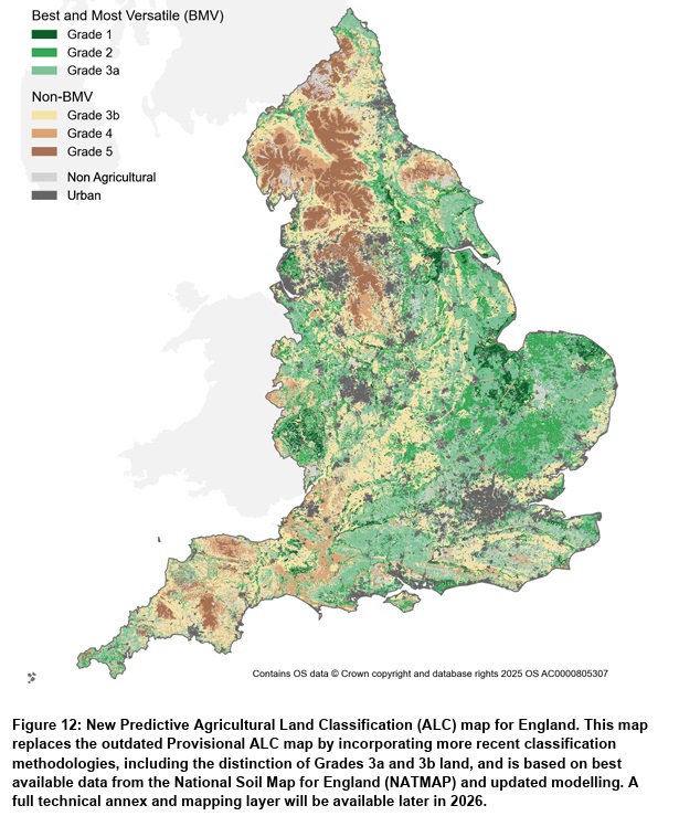
The ALC map above is easy to remember – it’s a mixture of a soil map, a relief map and a map of built up areas which leads any observer to look at the uplands as economically poor areas for agriculture. I wonder how many government ministers look at that map and could name the upland areas and spot The Weald and The Fens and have any idea what the landscape is like if you were standing on the farmland inland from Southport, on Bodmin Moor or in the Vale of York. How many could even join the dots of Bristol, Swindon, Oxford, Milton Keynes, Cambridge, Bury St Edmunds and Ipswich on this map? Maybe it should be on the wall of all Cabinet Ministers’ offices, and in the Cabinet room and in the corridors of power.
I will end this first rapid look at the England Land Use Framework by noticing that it bears some remarkable similarities to the 10-point plan at the end of Guy Shrubsole’s Lie of the Land – reviewed here. Maybe the pen is mightier than the shotgun and combine harvester after all. Well, it may be if, big IF, much of this government vision is actually delivered and quickly. Action on the ground is always the test. We will see whether this good start is transformed into great action.
[registration_form]
If you’re going to nod to Eric Morecambe, I’m going to nod to Sergeant Wilson out of “Dad’s Army”. Rather than barking out orders, this framework is very much a case of “Would you landowners mind awfully just changing what you’ve all been doing? How lovely!” A funded implementation plan would be nice.
btw ‘Making Land Digital’ is horrible. Will the Secretary of State have to wear a bright red MaLaD baseball cap?
Roger – I agree! Thank you for you first comment here.