Nick MacKinnon is a freelance teacher of Maths, English and Medieval History, and lives above Haworth, in the last inhabited house before Top Withens = Wuthering Heights. In 1992 he founded the successful Campaign to Save Radio 4 Long Wave while in plaster following a rock-climbing accident on Skye. His poem ‘The metric system’ won the 2013 Forward Prize. His topical verse and satire appears in the Spectator, and his puzzles and problems in the Sunday Times and American Mathematical Monthly. Email: nipmackinnon@gmail.com
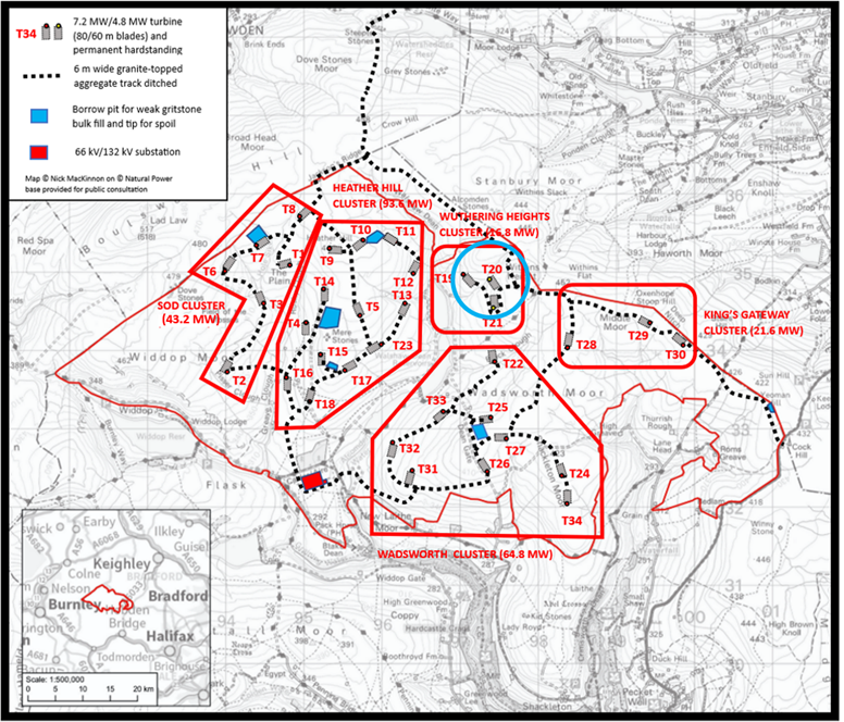
Turbine 20 Wuthering Heights SD 97413 34873 ///prefect.transmitted.swinging
This blog was sent to Calderdale Wind Farm (CWF, Christopher Wilson) and Logika (Marc Davies) on 17 April 2026. It was also sent to OWC (Offshore Wind Consultants Ltd), whose derelictions with respect to analysis of the risk of catastrophe on Crow Hill are described, so that they can take legal advice, given the seriousness of the conduct alleged and specified by the author. The matter of the blog has been sent to CWF Ltd to be dealt with formally during the Statutory Consultation and it thus enters the sequence of documents that must be considered by the Planning Inspectorate. The attention of CWF Ltd is drawn to the logged remark of the Planning Inspectorate following their meeting on 26 January 2026 encouraging positive collaboration with the author of this blog and with others similarly qualified, and the author offers his own positive collaboration in the blog.
The Runaway Jury is a terrific John Grisham thriller. The hero Nicholas Easter gets himself onto a jury trying a tobacco company in Biloxi, Mississippi. Once under Easter’s control, the jury acquires the momentum of a runaway train.
This long series of blogs might be called The Runaway Consultants. They can smell the jackpot: the eight-figure Environmental Statement for the DCO of an NSIP, whose price will exceed the seven-figure Scoping Report and eight-figure PEIR, the just-published preliminary environmental impact report.
My brother ran an off licence in Dumbarton for five long years and learned that “You have to farm your alcoholics” which meant keeping them alive. The consultants and Christopher Wilson stand in the same relationship.
CWF, the first version of this wind farm, was an amateur proposal. Christopher Wilson has never denied that he wrote the website, and no better explanation has been given for the way the professional Scoping Report (by Natural Power) failed to marry the comedy website. CWF was a non-starter and Natural Power said so, in the judicious way professionals treat their most hapless clients. Less judiciously, Donald Mackay, lead consultant to CEP (Calderdale Energy Park), said on 29 May 2025 that “It was worse than useless.”
The original sin in the Natural Power Scoping Report was that nobody looked at the British Geological Survey (BGS) Sheet 77 (Huddersfield) geology map to discover that the aggregates would have to be imported. The CWF proposal collapsed in October 2024 and Natural Power were let go. Frankness about “international, irreversible, negative effects” on an SAC, Alison Sidgwick missing the weak and porous aggregates, and a Scottish value of 50 cm for “deep peat” might have been the causes of the rift. When I rang Natural Power on 1 May 2025 (getting Emma at reception) to ask if they knew why 80% of the maps (still with the NP logo) were wrong on CEP Launch Day, James Lightbody told me, “I did some work on some wind farm near Halifax, but that was ages ago.”
Alison Sidgwick had been at Natural Power and was Approver for that first 2023 Scoping Report. She went independent and now has CEP among her clients. When I asked her (17 May 2025) whether she had looked at BGS Sheet 77 (Huddersfield) before signing off the doomed report, she said, “Oh, consultants don’t look at geology maps at this stage”. She may have felt some unease, because by 21 May 2025 the consultants had finally looked at BGS Sheet 77 (Huddersfield) and Donald Mackay (who has his own consultancy) admitted on film in response to our question that “the onsite aggregates are not the best for construction”.
Logika is another bunch of consultants servicing the onshore gold rush that involves ten times too much onshore generation being registered with National Energy System Operator (NESO). In a gold rush the certain profits are made by the people selling spades. I always run these blogs past Marc Davies the Growth Director of Logika for comment so there is a complete paper trail for the Planning Inspectorate. Always keep the receipts.
Logika has been the most incompetent element of the CWF Ltd proposal, apart from the original CWF website which was in a class of its own. When Jon Kimber, the Chair of Wadsworth Parish Council, joshed Mr. Wilson on 3 February 2026 with “Logika ought to give you your money back, Christopher!” poor old “440 Kelvin Volts” was only able to grimace. He is now the captive of his runaway consultants, who, like my brother in his off licence, are farming their alcoholics. For legal clarity, the “alcoholics” in this comparison are Christopher David Griffin Wilson, Dr Ghazi Mohammed Ahmed Osman and Algihaz Holding of Orouba Street, Alworoud Area, 6460, Riyadh, Saudi Arabia, and the “farmers” are the consultants who provide endless expensive analysis to keep the failing CWF Ltd alive.
One way the incompetence of the Logika Scoping Report pollutes the downstream analysis on the DCO will be made specific in this blog; many other examples will no doubt emerge as WTRG mine the PEIR, looking for the mismatches with the Scoping Report. The Planning Inspectorate want a chain of adequate consultation, like a provenance on Fake or Fortune with Fiona Bruce and Philip Mould: “Science can see beyond the human eye!”. The only sound way for Christopher Wilson to move forward is to go back to square one and do it all properly next time. The only sound way for the Saudi investors is to go back to square one with an Executive Chairman less vulnerable to sucker fish than Christopher ‘440 Kelvin Volts’ Wilson, whose consultants are eating him alive. If you can’t get the voltage of the National Grid right then you can’t control the consultants, who have achieved a classic Producer Capture of CWF Ltd.
My advice to sole Director Dr Ghazi Osman is: “Sack the lot except Donald Mackay; go back to square one with Donald as Executive Chairman, and ask him for a fag packet account of the problems of the site choice. Once you have that, you will invest elsewhere.” It is possible to explain the endless trouble on Walshaw Moor in ten minutes with one map, which was the minimum due diligence Dr Osman needed to do in February 2022. All the vampire consultants can do is sorrowfully lay out the far-too-late due diligence for eight-figures which Mackay could have explained in 2022 for £10000, and MacKinnon will do for nothing. Glad to be of service Dr O. This is “positive collaboration” in action.
WTRG are presently pursuing the invisible evidence that CWF Ltd considered alternatives to the site; the flip side of this search is that Dr Osman was not offered alternatives for his investment either. In that case, both the British people and the Saudi investors were railroaded onto unsuitable Walshaw Moor by Christopher Wilson, and that was confirmed by Donald Mackay himself at Trawden on 29 May 2025. MacKinnon: “Did CWF Ltd consider alternative sites.” Mackay: “That’s never how these stories go. A single landowner had a large plot.” Neither the curlews, the billpayers, the Secretary of State, nor Dr O seem to have been offered genuine alternatives to Walshaw Moor. Again the PEIR sets out the key mismatches on alternatives with the 2023 website.
Dr Osman should have done his own due diligence in February 2022 and it would have taken no more than an hour with a competent neutral. Aggregates? Access? Designations? Who is Emily Brontë? How many MW on the flat topsvale like Scout Moor? Connection?). Instead he is the figurehead of a case study in eight-figure incompetence that will enchant MBA students from Harvard to Huddersfield for decades.
We now have the enormous PEIR and it is a gold mine. It has been written by a range of consultants, and parts of some reports are plainly excellent. When my brother was farming his alcoholics he would offer them one bottle of Laphroaig instead of three Infamous Grouse because he wanted them to live as long as possible. The consultants have their self-respect and reputations to keep in repair, because they want to work with reputable developers after this lucrative CWF Ltd gig so there is plenty of good quality work in the PEIR. As the proposal is a turkey on simple first principles, very expensive evidence cannot make it a curlew. Christopher Wilson is a property developer who has not erected a single wind turbine. There is blood in the water for the consultant swarm.
The PEIR is vast, and so far we have only sampled it for quality, but we know enough to say that CWF Ltd are in big trouble now and that the Planning Inspectorate have logged the essential problem: CWF Ltd are not engaged in positive collaboration with the campaign groups who know where the due diligence failed on first principles, know the whole proposal inside out in ways consultants in topic silos can never do, and now have the gold mine of the PEIR. The salami slicing and siloing of Nationally Significant Infrastruture Project (NSIP) proposals are criticised as favouring the developer, but they don’t if the site is as unsuitable as Walshaw Moor and the opposition have a panoptic view while the consultants are in their small corners.
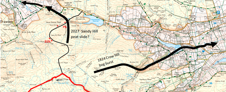
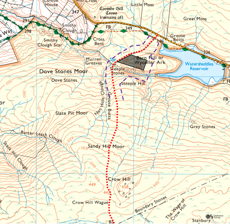
This blog will be a deep dive in the single silo of PEIR Appendix 10-4 in which OWC make a Preliminary Peat Landslide Hazard Risk Assessment using data provided by Fluid Environmental Consulting, much of which goes back to the April 2022 survey, two of whose personnel were observed by Andy Cockroft: “A lad and lassie sliding around north of Gablestone; the peat’s really deep there.” What we shall find reveals the cynical contempt of OWC for the proposal and its backers. They are Runaway Consultants.
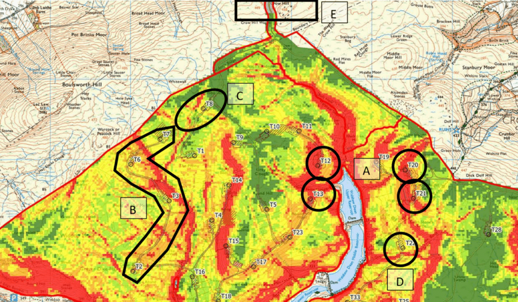
PEIR Appendix 10-4 seems excellent. It does the Factor of Safety calculation (albeit using book values for peat cohesion) that we could only do relatively. We did our work by hand at individual points (we chose the obviously dangerous ones with some obviously safe ones for comparison) but OWC map an estimated absolute factor of safety over almost the whole proposal. The crane is the heaviest machinery, so the important map is the OWC Factor of Safety under Crane Load, a detail of which is shown below. As readers know, I always do my maps on this base, the colossal laminated OL21, and I am delighted that OWC agree. It has only taken CWF Ltd 2½ years to catch up with the quality of the Walshaw Turbines blog maps.
A] Our old friends T20, T21, T12 and T13, and their access tracks, are in the red. These are on much steeper ground than any turbine in the Pennines, which elsewhere give such a famously flat platform for wind farms that it has never been necessary to propose infrastructure on unstable ground. This problem has been evident since the beginning; it got worse when the turbines got bigger.
Greed has pushed the CEP turbines over the edge and too close together, with T12-T13 being excellent examples. To make these sites safe will require wholly disproportionate excavation and destruction in the Special Area of Conservation. Since T12 is deep in the wake of T13, it is doomed anyway. The question is, “Why are these turbines part of the design?” The answer, until we are given a better one is: “The runaway consultants need them to keep up the power or the investors will cancel the gravy train.”
B] Now look west of Greave Clough at our highlighted squiggle. At the Trawden non-statutory consultation I said to Donald Mackay, “I can’t draw a track network west of Greave Clough. I can’t go sideways here, can I?” He shuddered when I ran my finger along T2-T3-T6 (highlighted above) and breathed, “No! No! We don’t go sideways there.” Since the track also runs along the principal onsite flood risk in Cross Dike (not the same as the offsite flood risk caused by the whole development) this sideways access track on the steep peat west of Greave Clough won’t work without disproportionate destruction in the SAC. Track T2-T3-T6 is a turkey on first principles and the OWC map highlights it nicely. OWC say there has to be realignment of the track in relation to the unstable ground. Extra peat depths have been taken on the given tracks (they show as black spots along the tracks that are not on the 2022 probing grid in the map below). When the track is realigned, new unstable peat will be found by Fluid Consulting on the new track. The point is that you never go sideways here on first principles, but certainly not in an SAC where you have to respect the peat by law. As the OWC report says:
Avoid cutting trenches or aligning excavations across slopes (which may act as incipient back scars for peat failures) unless appropriate mitigation has been put in place.
CWF Ltd cannot legally mitigate the risk by stripping Field of the Mosses down to bedrock across a wide swathe and dumping the spoil in a borrow pit. Ain’t no borrow pit deep enough.
C] T8 (Fox Hole Top) is a normal Pennine turbine location. T7 (The Sod) is inaccessible from below without disproportionate destruction in an SAC, but there is also a track down from T8. The aim is to create a one-way circuit and reduce passing places We have walked over T7-T8 extensively and have concluded that a lot of peat would have to be shifted and the watercourses are really difficult. OWC helpfully observe that “There is an area of minor gully collapse on an unnamed tributary of the watercourse falling through Bullion Clough.” It is falling down even without being loaded. Donald Mackay can only build these cut tracks by making a disproportionate mess of the SAC west of Greave Clough, and the OWC factor of safety map illuminates our first principles assessment.
I told Donald Mackay that he would be culling the Scout Ridge and Dove Stones on visual grounds anyway (He said “They are on charismatic ground”) and they are gone. We predicted this long ago, imagining Christian Egal on a rare site visit, standing at Dove Stones and saying, “But this is lovely; the campaigners will take photographs here. Cull these turbines.” Developers are obsessed with the visual. The real problem was the gross destruction to the SAC in reaching them safely, and this continues for T1, T2, T3, T6 and T7, which we call Sod Cluster.
D] This blog has had a long interest in how to get the components to the bottom of Black Clough. The present solution is a grim traverse that I shall never walk along. John Page can do it; he’s even done T12 to T13 across Grey Fosse Clough and it only took him 90 minutes! The traverse is on red (unsafe) and orange (marginal) ground with a final crossing of the unstable strip in the clough itself. Normal people, who include me and the gamekeepers, get to T22 up or down the clough itself, but this is much too steep for component delivery. Cutting in from the Pennine Way is one of the most horrible walks on the site, with endless unmapped drainage. Track T33-T22 makes a disproportionate mess in the SAC.
So, OWC have done their work well at A-D; it is what CWF Ltd do with the answers at A-D that matters, and it will cull or move turbines and tracks that should never have been there in the first place, but for the consultants’ need to maintain power as the site shrank.
E] The OWC report details the 1824 catastrophe on Crow Hill but no peat measurements were taken by Fluid on the main access track up which the stone and turbine components have to come, where we identified the maximum danger of peat slide in the whole proposal. Fluid share no blame for this failure, but at the moment, the only GPS peat depths known north of Crow Hill were found my me with an avalanche pole and an Airedale called Teddy on 1 August 2025. Further up, Teddy almost drowned on Crow Hill Wague. I left my rucksack with car keys at a probe point in the wilderness, but an hour later remembered I had recorded the grid references of all the places it might be. Someone’s got to do it if Fluid can’t.
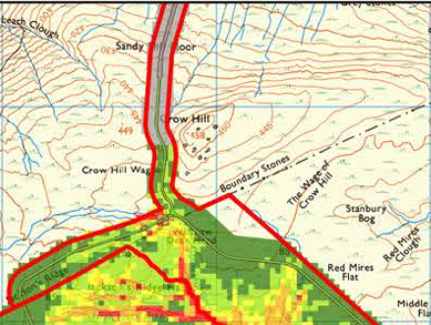
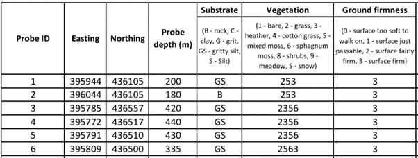
The data at the four most northerly probes on Crow Hill can easily be found in the vast spreadsheet now on offer in the PEIR because they are new and farthest north: Probe numbers 3, 4, 5 and 6.
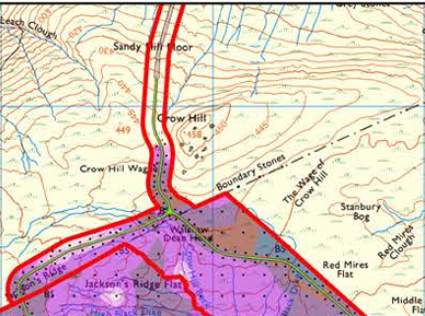
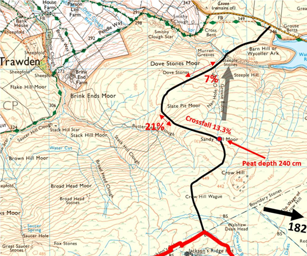
This peat is really deep (far beyond my 3-metre avalanche probe) but isn’t going anywhere because the Crow Hill Wague is flat, and here the track can float. The maximum danger is on the convex north slope of Crow Hill, where the map has “Sandy Hill Moor”. As the OWC report says (in a useful bit of generic cut-and-paste):
Preconditioning factors may influence peat stability over long periods of time (years to hundreds of years), and include:
-
-
- Impeded drainage caused by a peat layer overlying an impervious clay or mineral base (hydrological discontinuity).
- A convex slope or a slope with a break of slope at its head (concentration of subsurface flow)…
-
What is unknown is why the peat has piled up so deeply precisely at the convexity (my datum 240 cm). In a spirit of positive collaboration, I shall indicate the unusual mechanism, unique to Crow Hill, later. Steep slopes usually have shallow peat. Mountaineers hope that dangerous accumulations at steep convexities have avalanched already; the subtle danger is deep snow on shallow uniform slopes. Every winter mountaineer reading this shudders at the thought of that convexity, and wonders about the cohesiveness and layer structure to be found there. Despite what we now know to be total ignorance, an access track in S-bends over north Crow Hill was published at the Non-statutory Consultation on 29 April 2025.
This track was identified during the consultation as a prima facie peat slide risk by John Page, who wrote a Walshaw Turbines blog on it. Once we had put the useless CWF Ltd map on a proper base, he was able to pinpoint the maximum danger despite our lack of peat depths.
Donald Mackay signed off the S-bend track and I wondered here if he had any peat data to justify putting his creation in front of the public at a non-statutory consultation governed by the Gunning Principles. The WTRG legal team expect this dereliction on a matter that might cause a catastrophe may be sufficient to send the proposal back to square 2 (rerun the non-statutory consultation) and the refusal of CWF Ltd to explain themselves simply delays the inevitable.
We were unable to comment quantitatively on the matter because the consultation opened on 29 April 2025 and closed on 10 June 2025, wholly within the ground-nesting bird season. I probed the track on the first legal day, finding 240 cm at the convexity on the most dangerous possible place in the track geometry, where the loads exert a radial downhill force as they turn, exactly as John Page had predicted from first principles. Our map of relative peat slide risk appeared in the blog on Black Clough sent to CWF Ltd (Christian Egal) and Logika (Marc Davies) on 13 October 2025.
Our analysis, which was taken up by three Statutory Consultees and appears in the Scoping Opinion (p 384-391) adopted by the Secretary of State on 10 October 2025, concluded:
Requirement for an early report on Crow Hill
“12.21 Given that access via Crow Hill is existential for the proposal, statutory consultees should not be required to maintain concern for the proposal as a whole under very short deadlines (42 days for the non statutory consultation and just 29 days for the SR) until independent research is completed and the report on access via Crow Hill is published. Detailed research and analysis of the Crow Hill access should be published before the beginning of the Statutory Consultation since it is existential for the proposal. The consultation is anticipated to begin in “Winter 2025” and must be delayed if no conclusion on peat slide risk on Crow Hill has been reached. If consultees are to engage with confidence in Statutory Consultation, they must be convinced ab initio that there is safe access to the site before they are required to expend further public money, charitable funds and expert management time responding to the proposal.” (Stronger Together Scoping commentary)
On 26 January 2026, following a meeting with CWF Ltd, the Planning Inspectorate, logged a comment on the attitude of CWF Ltd to our work. Noting how extensive our Scoping Report analysis was, and how many statutory consultees had adopted it, the Inspectorate “encouraged positive collaboration and engagement with the action group [Stronger Together] and any other participants.”
The fact is that between Stronger Together and Ban-the-Burn (whose excellent commentary also appears in the Scoping Opinion) the Scoping Report was shredded. To form any kind of foundation for the DCO process, CWF Ltd had to correct their Scoping Report by interleaving the commentaries of Stronger Together and Ban-the-Burn, thus working with the “positive collaboration and engagement” that the Planning Inspectorate “encourage”. Had CWF Ltd taken their duty seriously in this matter, OWC might not have cut corners and made their shocking mistakes in Appendix 10-4.
In the PEIR, the access track is completely remodeled. Despite Statutory Consultation having begun, no useful map of it has been published, so to begin analysis, we have prepared our own.
Clearly CWF Ltd accepted our analysis that the April 2025 track they presented at the Non-statutory consultation posed a completely unacceptable risk of catastrophe and redrew their track. Engineering analysis of the April 2026 track is presently impossible for WTRG or CWF Ltd, because Fluid were not asked to continue their probing downhill. OWC have to mark the area “No calculation”. The proposal has entered Statutory Consultation without any data on the only existential aspect of the proposal, and none of the Statutory Consultees can employ consultants to get the data during the Statutory Consultation because once again the consultation has been timed to fall within the ground-nesting bird season. This pattern replicates precisely the behaviour of CWF Ltd during the Non-statutory Consultation.
The April 2026 track will be cut to bedrock through a ten-metre-wide swathe of the SPA, producing a vast pile of peat spoil with nowhere to go. If undisturbed, peat stores carbon and is the foundation of irreplaceable habitats. Dug up peat is classified as a dangerous industrial waste, and CEP propose to dispose of it in onsite pits. The track is aimed like a rifle at Watersheddles Reservoir with obvious consequences for hydrology. The toe of the peat slope must be removed first and the track then cuts its way up to the unusual accumulation at the convexity. No information has been given about traction on the initial section where delivery vehicles of all kinds must suddenly go up a 17% slope from a standing start on level ground.
Because no data has been obtained, nor can be obtained until 1 August 2026, it is impossible for the Statutory Consultees to assess this existential aspect of the proposal, where they have previously been offered a dangerous track, signed off by Donald Mackay despite his ignorance of the peat depths. The new consultants OWC appointed by CWF Ltd cannot assess the north slope of Crow Hill. This ignorance would not be acceptable at this stage even in a minor turbine spur, nor is it deemed acceptable by OWC, who have presented the calculation for every track within the turbine area and made a general recommendation that the turbine layout and tracks will be redesigned in the light of the stability, a recommendation that would apply a fortiori to the existential access track if only OWC had been given the data.
This access track has already been redesigned once, and since CWF Ltd and Donald Mackay had no peat evidence, we can only assume that they redesigned it because of the Stronger Together analysis, but we could only make that analysis long after the non-statutory consultation closed, and we can make no analysis of the new track until after 1 August 2026. Since it cannot go up in S-bends, if the now straight track risks destabilising the north slope of Crow Hill, there is no access left for the proposal. This is why this matter had to be dealt with properly before the Statutory Consultation opened.
Failure to assess the sole access track is breathtaking incompetence going into a Statutory Consultation. This, at least, is not the fault of OWC, who are careful to distance themselves from the decision to enter Statutory Consultation without the data on Crow Hill. It is wholly the fault of CWF Ltd.
The fatal weaknesses in any NSIP DCO application are:
- Poor early stage assessment;
- inadequate baseline data;
- unjustified scoping-out decisions;
- loss of stakeholder confidence;
- methodological inconsistencies;
- underestimation of environmental impacts;
- failure to address designated sites (SAC/SPA/SSSI) properly.
Since they were told by the Planning Inspectorate that they could not scope out catastrophes from their assessment and yet they have persisted to treat the primary locus of catastrophe as though it was scoped out for the Statutory Consultation, CWF Ltd have exhibited all seven of those fatal weaknesses in the most catastrophe-prone aspect of the proposal. Nothing can be done to model the risk until 1 August 2026, when Statutory Consultation will have long closed. yet CWF Ltd propose to submit their DCO application in November 2026. They are in contempt of the planning process.
The modelling of the north slope of Crow Hill cannot depend on the book values of cohesion and angle of friction used by OWC to model stability within the turbine area. This is because:
- Crow Hill is the recorded locus of eight peat slides by the OWC counting method.
- Crow Hill is existential to the proposal and no work-around is possible, as might be allowed in the turbine area
- The eight recorded peat slides on Crow Hill happened in response to a sudden change in cohesiveness, so specific investigation on the Crow Hill north slope is required to model the response to variation in saturation for cohesiveness in situ.
- Even a small peat slide on Crow Hill can cause multiple deaths to construction workers because it is the sole access and the trigger is likely to be the work force
- A peat slide on Crow Hill would undermine Government policy on onshore wind for a generation
- The peat slide would enter a drinking water reservoir causing a displacement that would overwhelm a dam poised over the settlements in the Worth Valley
This is all obvious and none of it need to have been news to Christopher Wilson had CWF Ltd responded properly to the shredding of the Logika Scoping Report. In the Scoping Opinion on the Logika report, adopted by the Secretary of State on 10 October 2025 is this section, written by WTRG, and adopted by several Statutory Consultees it says:
Survey and analysis required
12.10 8.2.2 references “Peat Landslide Hazard and Risk Assessments: Best Practice Guide for Proposed Electricity Generation Developments (Scottish Government, 2017) (SR footnote 133)” which should set the baseline method for peat landslide risk assessment on Crow Hill.
12.11 Equation 8 of SR footnote 133 states how a safety factor F can be found. Given the existential nature of the peat slide risk for the whole proposal, slope convexity, the triggering factors of very heavy deliveries, the weight of aggregate used to build the track, a predicted pattern of long dry spells and intense rain, and the proximity of the catastrophic peat slide of 1824, values of c′ (effective cohesion) and z (peat depth) must be established by onsite peat coring and probing at a variety of saturations m. Note the known high z-value already found (peat depth 240 cm at the turn) and the high value tan-1 (0.133) of β calculated on the published track.
12.12 Values of c′ from peat coring should be presented in tabular form at a range of values of m including full saturation, correlated with values of z at the same locations and the resultant value of F. Peat cohesion is strongly dependent on fibrosity and saturation. Fibrosity is likely to vary over short scales, so a 10-metre probing-and-coring grid is minimum. Given the existential nature of the area, a finer grid may be indicated.
12.13 Given the present drought, it is possible that c′ at values of m near (and at) saturation might not have been measured by 28 February 2026. A dispensation from Natural England to perform peat coring and peat depth probing during the ground nesting bird season of 1 March – 31 July 2026 should be sought to allow ongoing measurement of cohesiveness in a variety of saturation regimes.
12.14 Dykes and Kirk [p 391] explain why the Yorkshire drought of summer 1824 might be a proximate cause of the 2 September 1824 Crow Hill catastrophe. The same explanation applies to the 1989 Crow Hill peat slide. Dykes and Kirk explain that in a drought, dry peat masses with “lower water contents and lower liquid limits” undergo “a decrease in particle size” which triggers “the close packing of the organic particles and the consequently smaller pores and higher bulk density.” Consequently, it “would take a smaller increase in water content to bring about significantly higher water pressures or even a change of state.”
12.15 The present difficulty of obtaining cohesiveness values at high saturations is a consequence of weather instability that itself contributes to the baseline risk of peat slides on Crow Hill, and are further consequent of the site choice and access choices made by CWF Ltd.
12.16 Because of the existential nature of the Crow Hill access, statutory consultees and the Secretary of State must have high confidence in the survey for peat depth z and effective cohesiveness c′ and in the reliability of the subsequent analysis. The work should be independently conducted and peer reviewed and published in good time before the beginning of Statutory Consultation, which may have to be delayed. (WTRG with Stronger Together).
CWF Ltd had ample time to do the the survey work following the Secretary of State’s adoption of this analysis on 13 October 2025. They did not need to apply to Natural England to do it in the nesting season. They did not do the work.
Unfortunately, the behaviour of OWC in the matter of the Crow Hill peat slide analysis described below shows that they cannot be considered a fit and proper company to undertake the independent and peer-reviewed research. .
How competent are OWC? They give an immediate disclaimer about the fatal weakness.
The Bradford West Cable Corridor … and the Access Routes have yet to be surveyed and therefore these components of the Proposed Development are not considered within this technical appendix.
The OWC maps inside the turbine area are excellent. I have checked some points by hand found no error in the factor of safety maps. The modelling is conceptually correct and the data has been correctly used. It is a deficiency of the PEIR as a whole that there is no plain map of the infrastructure on the 25000 OS base, but one of the OWC maps functions well enough. The report continues:
There are no published failures or news reports of landslides in proximity to the Proposed Development. Review of the nearby wind farms in similar settings (Hyndburn Wind Farm, Coal Clough Wind Farm, Todmorden Wind Farm, Reaps Moss Wind Farm, Crook Hill Wind Farm and Scout Moor Wind Farm show no evidence of failures in association with construction). [The bracket typo and show/shows are OWC’s.]
This is a specious comparison, because as we have often observed, and again in our commentary on the Scoping Report for the Planning Inspectorate, none of the comparator Pennine windfarms listed have turbines on ground of more than 12% slope, and that 12% relates to a single small turbine on Coal Clough WF. Otherwise, the maximum gradient is 10%, but with the Pennines having extensive flat tops, most turbines are on almost flat ground. In a desperate search for the last 50 MW, CEP has put its huge turbines in some very strange places. Back to OWC whose trouble starts now.
To the north of the Proposed Development, there are two recorded peat landslides (eastern and western), one, or both of which are known together as the Crow Hill bog burst (Ross, 2020), described by the Rev. Patrick Brontë. The eastern landslide is connected to Ponden Clough Beck, with impacts on this watercourse being described in Brontë’s account of the event. The western landslide is located closer to Crow Hill, but is connected to Crow Hill Beck. Both were reported by Brontë as occurring during the same meteorological event. Accounts of effects on watercourses documented in Ross (2020) include effects in Leeds and even effects on water colour as far east as the Humber Estuary. These distances are far in excess of impacts documented for peat slides, though some bog bursts documented in Ireland have reported far-reaching impacts extending to tens of kilometres.
Note the tendency to diminish Ross by suggesting that the effects described, with contemporary evidence, seem excessive. What the analysis should conclude is that something happened on Crow Hill on 2 September 1824 that was so extraordinary as to be indicative.
What puzzles the reader of the OWC account is that what might be considered one event is separated by OWC into two events and then put back into one event. There is no such eastern/western division in Ross (2020).
The cause of this confusion is that OWC have not read Ross (2020) at all and instead have been misled by the incompetent Logika Scoping Report and are trying to cover the under-referenced second peat slide of SR with a second peat slide in the 1824 event. If we use the counting method, 1824 would come to six peat slides, one on Tuesday 2 September, four on Thursday 4 September and one more later. OWC add the Stanbury Bog slide of unknown date they want to exile to the distant past (seven), but there is still one more …
SR 8.3.26 To the north and outside of the Turbine Area, there are two recorded peat landslides, one of which is known as the Crow Hill bog burst (Ross, 2020), described by the Rev. Patrick Brontë. LiDAR data indicates no equivalent features within the proposed turbine area. (Logika Scoping Report).
In fact, Ross considers the 1824 peats slides to be a single event. The second recorded peat slide, which Ross also discusses, was in 1989.
Had OWC actually read Ross (2020) they would have found the second peat slide was in 1989 and is thus highly germane to their analysis of Crow Hill. OWC now continue to muddy the waters because they do not know about the 1989 second peat slide. They turn 1824 into two peat slides so their report matches the Scoping Report and then turn them into one peat slide over 200 years ago.
A similar feature is located in Stanbury Bog to the southeast of Crow Hill. Its morphology (form) is less clear than that of the Crow Hill burst and it may be of a similar age (i.e. not recent). Stability of the westernmost bog burst has yet to be assessed in detail, but will be post-PEIR.
It is difficult to say just how many bog bursts OWC have found on Crow Hill. It looks like two “Crow Hill bog bursts” as reported by Patrick Brontë “west” and “westernmost” of Crow Hill and one east of Crow Hill in Stanbury Bog which “may be of a similar age”.
If we count peat slides the way OWC count them (because they need two and don’t know about 1989) then Ross (2020) gives six peat slides (two reported by Patrick Brontë. and four by J. Horsfall Turner) comprising the September 1824 event, to which we add the seventh OWC slide on Stanbury Bog which remains undated by OWC , and the crucial eighth peat slide of May 1989 of which OWC are ignorant, but whose recent date and cause is crucial to a proper analysis. Eight.
It is fatal for consultants to read the Logika Scoping Report without checking it against the Stronger Together commentary (used in toto by Oxenhope VC and Haworth-with-Stanbury PC) and the Ban-the-Burn commentary (for Wadsworth PC). The Scoping Report should have been corrected and reissued before it caused trouble. As it stands, its incompetence can only pollute the planning process miles downstream, as here in the analysis of catastrophic peat slide.
We have shown that OWC have not read Shawna Ross Charlotte Brontë at the Anthropocene, the master account of the key geological event on their site since the ice retreated which never leaves my desk.
If OWC had actually read Ross (2020) (they will have to do that now, if CWF Ltd decide to retain their services, and there will be a test) they would have found the reference to the second peat slide, which was not as they guess in 1824 but in 1989. Guessing! They are guessing about the most fundamental problem their client has: the frequency of catastrophic peat slides on Crow Hill, and they had to guess because they couldn’t be bothered to read their own references.
Not only have they not bothered to read Ross, they haven’t read any of the Warburton references that they cite so glibly, because had they done so, they would have found Professor Warburton’s photograph of the 1989 peat slide on Crow Hill.
Not only have OWC not bothered to read Ross and Warburton, but they haven’t read the Scoping Opinion adopted by the Secretary of State on 10 October 2025 which presently contains the master reference on the 1989 slide, because it integrates Warburton’s Crow Hill photograph and the weather to give probable date and cause. I wrote that master reference, and it took me three days of the 29 CWF Ltd made available for responses to their incompetent Logika Scoping Report.
“12.9 A second Crow Hill peat slide occurred on 19 May 1989. Dykes and Warburton (Mass movements in peat (2006)) give a photograph of the remnants of the 1989 slide taken in 2005. The extent was 3.6 ha, and 46000 m3. The peat was originally 2-3 metres deep and 0.3-0.5 metres of depth remains. The terrain is not steep and corresponds to the ground crossed by the Crow Hill access road at 440 metres just before the last bend. A prolonged drought had affected England from November 1988, punctuated by short-lived but often abrupt phases of wet weather. On 19 May 1989, a record 2-hour point rainfall of 193 mm was recorded at Walshaw Dean Lodge in the middle of the turbine area. This is the record daily rainfall for May, and the most intense 2-hour rainfall recorded in Britain. It is known as the “Halifax Storm”. The 1989 Crow Hill peat slide and 1824 Crow Hill catastrophe had in common intense rain following a drought. Droughts in the Walshaw catchment include 2023 when emergency pipes were laid by helicopter from Walshaw Dean to Ponden reservoirs, and the ongoing drought of Spring and Summer 2025.” (Nick MacKinnon for Stronger Together.)
There is no evidence that OWC have read Jeff Warburton, Peat Landslides because if they had they would have found the photograph of the 1989 Crow Hill peat slide and realised that they did not need to split the 1824 bog burst into two, and put it back into one, because the second peat slide that Ross discusses is in 1989, not 1824. Similarly OWC have not opened Charlotte Brontë at the Anthropocene because the second 1989 peat slide is clearly signposted and the exact reference given to Warburton, which is how I got there.
Warburton is cited fifteen times in the OWC Preliminary Peat Landslide Hazard Risk Assessment for Calderdale Energy Park, and the evidence presented here shows that none of those references was anything other than generic, a cut-and-paste job. If you haven’t read a reference then it is window dressing. Ross (2020) is referenced four times, and there is even a fifth reference to Ross (2021) which shows contempt for the master account of the 1824 peat slide, because Ross (2021) does not exist, except as an error when you look up the book on Amazon to blag a publication date for your fake bibliography. The bibliography also states that Ross (2020) has 334 pages, when in fact it has 326 pages. The leaf count is 334 pages, which is what you get if you ask Chat GPT for the number of pages in Charlotte Brontë at the Anthropocene. All that evidential detail will be of great use to the CWF Ltd lawyers when they ask OWC for their money back, and for compensation for the damage to the reputation of CWF Ltd, Christopher Wilson, Dr Ghazi Osman and Algihaz Holding that the gross carelessness of OWC with their own references has caused. As OWC put it themselves:
This document is confidential and may contain proprietary information and intellectual property of Client and/or OWC. The document has been produced by OWC for the exclusive use and benefit of Client and may not be relied on by any third party. OWC does not accept any liability or duty of care to any other person or entity other than Client. The document should not be reproduced (in whole or in part), referred to or disclosed in any other document or made available to any third party (in any format) without the prior written consent of OWC.
If OWC want to claim that I have infringed their copyright, which I shall say was manifestly in the public interest, they know where to find me.
Had OWC bought and opened Ross (2020) they would have realised that much of it is a post-doctoral examination of Brontë hermeneutics, so that page references to the 326 pages of text are essential. None of the four mentions of Ross (2020) nor the single mention of Ross (2021) in the OWC report specify the pages on which that cited evidence appears, and this is because they are not using the book. They are repeating hearsay and gossip, probably AI generated.
The OWC report states that AJM wrote it and NT, KW and DS checked it, except that they didn’t, did they. Four OWC consultants failed to discover the 1989 peat slide on Crow Hill in their own references and this is because nobody at Logika has bothered to integrate the Ban-the-burn and Stronger Together commentaries to create a more reliable foundation for the Environmental Impact assessment process. Had they done so, AJM at OWC could not have missed my master account of the 1989 peat slide and would not have had to appeal to a second 1824 peat slide to cover the incompetent reference to an undated second peat slide in the Logika Scoping Report. We say that failure to read your own references brings the Calderdale Energy Park into disrepute and shows cynical contempt for Christopher Wilson and for the Secretary of State for Energy Security and Net Zero, currently Ed Miliband.
This kind of disaster is why the Planning Inspectorate logged the advice given at the meeting with CWF Ltd on 26 January 2026. They “encouraged positive collaboration and engagement with the action group [Stronger Together at this point, but the Ban-the-Burn report for Wadsworth has similar power] and any other participants.” We know what we are talking about and we comprehend the whole. OWC are cut-and-paste bandits with a tame cartographer.
As OWC are now deep in it, they need some more guidance. Why does Crow Hill get the eight peat slides (their count; I would say one huge Crow Hill event comprising six recorded peat slides and bog bursts, one Stanbury Bog burst and one peat slide in 1989) and not higher and steeper Lad Law, nor Withins Height, the original Wuthering Heights? Will Crow Hill inevitably threaten peat slides on the client’s access track?
I’m not going to do the work for them because these bone-idle skivers at OWC need to take a pull on themselves, and if Christopher Wilson can’t get decent work out of them then I must try. But, in the spirit of positive collaboration encouraged by the Planning Inspectorate …
To make their model explaining the peat slides that infest Crow Hill, location of their client’s access track, first OWC must buy Shawna Ross, Charlotte Brontë at the Anthropocene (2020 p 326) and read it twice, with a pencil. Eventually they will find a key observation made by Patrick Brontë, who got almost to the heart of the matter in an 1824 sermon. While undertaking this desperate search for the goods, AJM of OWC will learn the hard way why page references are required when citing complex sources and why we professionals state page numbers, not leaf numbers of books cited. Then AJM, NT, KW and DS should read their own report again, because the key explanatory factor on Crow Hill is bullet-pointed in their own generic cut-and-paste. And finally, AJM should ask Alison Sidgwick what she seems suddenly to have realised at Oxenhope at 12.15 p.m. on 17 May 2025.
++++++++++++++++++++++++++++++++++++++++++++++++
This is the 56th in a series of guest blogs originally based on the 65 wind turbines which Richard Bannister planned to have erected on Walshaw Moor.
The developers canned their original 65 wind turbines, quite possibly in response to the public humiliation of having their so-called ‘plan’ publicly shown to be damaging, irrational and probably unlawful. They came back with a plan for 42 wind turbines and the amazing Nick MacKinnon and friends ridiculed that so-called plan. Now the developers have brought forward a 34-turbine revision – the series continues.
To see all the blogs – click here.
[registration_form]
Nick’s description of living near Wuthering Heights really highlights the contrast between the area’s literary and natural heritage and the modern energy landscape. It makes me wonder how other rural communities are balancing these same issues.